Category:Maps of the history of Latvia
Jump to navigation
Jump to search
Countries of Europe: Albania · Andorra · Armenia‡ · Austria · Azerbaijan‡ · Belarus · Belgium · Bosnia and Herzegovina · Bulgaria · Croatia · Cyprus‡ · Czech Republic · Denmark · Estonia · Finland · France‡ · Georgia‡ · Germany · Greece · Hungary · Iceland · Republic of Ireland · Italy · Kazakhstan‡ · Latvia · Lithuania · Luxembourg · Malta · Moldova · Montenegro · Netherlands‡ · North Macedonia · Norway · Poland · Portugal‡ · Romania · Russia‡ · Serbia · Slovakia · Slovenia · Spain‡ · Sweden · Switzerland · Turkey‡ · Ukraine · United Kingdom
Limited recognition: Abkhazia‡ · Kosovo · South Ossetia‡ · Transnistria · Northern Cyprus‡
‡: partly located in Europe
Limited recognition: Abkhazia‡ · Kosovo · South Ossetia‡ · Transnistria · Northern Cyprus‡
‡: partly located in Europe
Subcategories
This category has the following 14 subcategories, out of 14 total.
Media in category "Maps of the history of Latvia"
The following 64 files are in this category, out of 64 total.
-
 BielensteinLettgallenSemgallenKurenLiven1250.jpg 4,718 × 4,180; 3.59 MB
-
 OldCourland.jpg 1,700 × 2,730; 821 KB
-
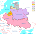
 Polish-Lithuanian Commonwealth (1619) compared with today's borders (ENG).png 3,133 × 2,997; 173 KB
-

-
 Baltikum 1686.png 885 × 700; 88 KB
-
 6. Sverige erobrer Ingria og Kexholm i 1617 og Letland i 1629.png 2,000 × 2,541; 617 KB
-
 Backsteingotik in Estland und Lettland.png 600 × 632; 551 KB
-
 Baltic border change after ww2.png 420 × 687; 34 KB
-
 Baltic Sea Borderlines 1939 german-it.png 2,528 × 1,965; 458 KB
-
 Baltic-Province 1708-to-1809.png 922 × 901; 101 KB
-
 Baltiskai gintu.png 2,000 × 2,185; 587 KB
-

-
 Bundesarchiv R 49 Bild-0705, Polen, Herkunft der Umsiedler, Karte.jpg 800 × 602; 274 KB
-
 CourlandGovernorate1914.png 1,262 × 837; 190 KB
-
 Die 'großzügigste Umsiedlungsaktion' with Poland superimposed, 1939.jpg 800 × 602; 206 KB
-
 Europe of to-day (1922) (14802414573).jpg 1,774 × 2,390; 628 KB
-
 FileRzeczpospolita2narkor.png 1,957 × 1,539; 532 KB
-
 Gebietskommissariat Slonim.jpg 1,548 × 2,139; 1.17 MB
-
 Gen Okrug Belarus Administrative.png 660 × 980; 165 KB
-
 Granica polsko-łotewska.png 200 × 96; 19 KB
-
 Karte polnischeteilungen4.png 701 × 600; 595 KB
-
 Kurische Könige in der Rückerschen Karte.jpg 1,775 × 1,574; 2.08 MB
-
 Lettsche EM-Platzierungen.PNG 1,200 × 1,000; 69 KB
-
 Liivinmaa 1260.png 1,153 × 1,248; 466 KB
-
 Lithuania, Latvia and Estonia (1923).JPG 1,809 × 1,357; 2.19 MB
-
 Livland1560-85.gif 1,890 × 1,370; 183 KB
-
 Livland1585-1710.gif 1,890 × 1,370; 168 KB
-
 Livon-war-post 1583.png 2,461 × 2,825; 157 KB
-
 Livonia 1.PNG 158 × 120; 2 KB
-
 LivoniaGovernorate1914.png 1,175 × 1,005; 205 KB
-
 Livonian in Latvia on CIA map PL.jpg 633 × 325; 24 KB
-
 Livonskaya war.gif 650 × 944; 71 KB
-
 Lívek a 12. században számokkal.png 1,500 × 829; 330 KB
-
 Lívek a 12. században.png 1,500 × 829; 329 KB
-
 Map of a Russian war in the Baltics.jpg 1,279 × 1,244; 179 KB
-
 Mapa d'Estonia.png 634 × 650; 158 KB
-
 Metsepole.jpg 655 × 335; 68 KB
-
 OberOstMap-fr.png 1,196 × 2,000; 551 KB
-
 OberOstMap.png 1,196 × 2,000; 609 KB
-
 Pas neutralny PL-LT i okupacja łotewska.PNG 559 × 512; 16 KB
-
 PBW June 1920.png 2,000 × 1,534; 339 KB
-
 PNG Jagelon.png 1,268 × 1,054; 90 KB
-
 Polish-Lithuanian Commonwealth (1619) compared with today's borders (noname).png 3,133 × 2,997; 123 KB
-
 Polish-Lithuanian Commonwealth (1619) compared with today's borders PL.png 3,133 × 2,997; 177 KB
-

-
 Positionskarte EE + LV 1260.png 794 × 861; 120 KB
-
 Reichskommissariat Ostland Infobox.png 500 × 747; 114 KB
-
 Reichskommissariat Ostland.png 442 × 448; 41 KB
-
 Russia Empire 1800-1900.PNG 1,357 × 628; 36 KB
-
 Rzeczpospolita 1789-1920.png 2,000 × 1,534; 230 KB
-
 Rzeczpospolita 1920 claims names.png 2,000 × 1,534; 359 KB
-
 Rzeczpospolita 1923.png 2,000 × 1,534; 346 KB
-
 Selija.jpg 655 × 335; 69 KB
-
 SovietBlockade1940.jpg 1,452 × 1,052; 1.39 MB
-
 Sw BalticProv 1914 fr.png 922 × 903; 93 KB
-
 Sw BalticProv en.png 922 × 829; 624 KB
-
 Sw BalticProv fr.png 922 × 901; 94 KB
-
 Sw BalticProv ru.png 922 × 829; 458 KB
-
 Talava.jpg 655 × 335; 71 KB
-
 Traité de Varsovie (1705).png 1,110 × 1,600; 115 KB
-
 Turaida lahing.jpg 685 × 834; 209 KB
-
 Ümera lahing (1210) hu.svg 699 × 676; 146 KB
-
 Ümera lahing (1210).gif 699 × 676; 28 KB
-
 Геополитический статус стран Северной Европы в 1939.jpg 4,855 × 3,501; 1.2 MB


_compared_with_today%27s_borders_(ENG).png)
_compared_with_today%27s_borders_(Russian_version).png)


_(14802414573).jpg)


.JPG)


_compared_with_today%27s_borders_(noname).png)
_compared_with_today%27s_borders_PL.png)
_compared_with_today%27s_borders,_Ukrainian_version.png)


.png)

_hu.svg)
.gif)
