Category:Maps of the Southern Pacific Railroad
Jump to navigation
Jump to search
Subcategories
This category has the following 2 subcategories, out of 2 total.
Media in category "Maps of the Southern Pacific Railroad"
The following 14 files are in this category, out of 14 total.
-
-
 Large-scale-detailed-old-map-exhibiting-the-several-pacific-railroads-1883.jpg 10,030 × 6,250; 33.15 MB
-

-
 Streckennetz 1883.jpg 3,494 × 1,904; 2.05 MB
-
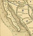
 A glimpse of Great Salt Lake, Utah (1891) (14765527665).jpg 1,982 × 2,970; 1.5 MB
-
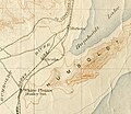 White Plains, Ocala, and Miriam Nevada in 1910.jpg 2,599 × 2,256; 1.86 MB
-
 Southern Pacific Company system map (1918).svg 1,400 × 800; 932 KB
-
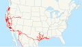 Southern Pacific Company system map (US only) (1918).svg 1,400 × 800; 961 KB
-
-
 SP Map.png 1,000 × 727; 51 KB
-
 Beaverton cut-off.png 896 × 807; 145 KB
-
 Map of the Southern Pacific RR between Ochoa and Dragoon Summit - NARA - 84786266.jpg 25,377 × 7,072; 13.55 MB
-

-
 G. W. & C. B. Colton & Co. True Southern Pacific Railway c. 1881 UTA.jpg 9,594 × 3,594; 9.22 MB
_(14594814447)_(cropped).jpg)

_(14594814447).jpg)

_(14765527665).jpg)

.svg)
_(1918).svg)
_(14780858323).jpg)


_(page_41_crop).jpg)