Category:Maps of the East Bay Electric Lines
Jump to navigation
Jump to search
Media in category "Maps of the East Bay Electric Lines"
The following 5 files are in this category, out of 5 total.
-
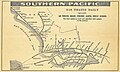 SP-East-Bay-1911.jpg 2,248 × 1,352; 465 KB
-
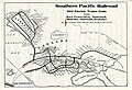 1919-07-00SP-USRA BayFerry-ElecTrns.jpg 3,385 × 2,310; 1.78 MB
-
 1927 East Bay Electric Lines and Key System map.jpg 5,952 × 3,128; 5.21 MB
-
 1927 East Bay Electric Lines map.jpg 2,880 × 2,083; 954 KB
-
 1939 Interurban Electric Railway map.jpg 2,772 × 2,564; 508 KB


