Category:Maps of Paris 7e arrondissement
Jump to navigation
Jump to search
|
Paris 1 • 2 • 3 • 4 • 5 • 6 • 7 • 8 • 9 • 10 • 11 • 12 • 13 • 14 • 15 • 16 • 17 • 18 • 19 • 20 |
Wikimedia category | |||||
| Upload media | |||||
| Instance of | |||||
|---|---|---|---|---|---|
| Category combines topics | |||||
| 7th arrondissement of Paris | |||||
municipal arrondissement in Île-de-France, France      | |||||
| Instance of |
| ||||
| Location | Paris, Grand Paris | ||||
| Located in or next to body of water | |||||
| Head of government |
| ||||
| Inception |
| ||||
| Population |
| ||||
| Area |
| ||||
| Replaces | |||||
| official website | |||||
 | |||||
Subcategories
This category has the following 5 subcategories, out of 5 total.
E
- Eiffel Tower maps (12 F)
Media in category "Maps of Paris 7e arrondissement"
The following 14 files are in this category, out of 14 total.
-
 Fg St Germain 1790.JPG 4,744 × 4,066; 3.6 MB
-
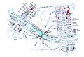
 7e arrondissement paris.JPG 769 × 494; 86 KB
-
 7th arrondissement of Paris - OSM 2020.svg 2,114 × 1,396; 1.75 MB
-
 Emplacement tour Eiffel 7e arrondissement.JPG 993 × 750; 134 KB
-
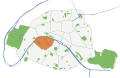
 Map commune FR insee code 75107.png 756 × 605; 85 KB
-
 Map of the 7th arrondissement of Paris - OSM 2020.svg 2,114 × 1,396; 1.78 MB
-
 Metro 7mo arrondissement.png 1,398 × 928; 277 KB
-
 Paris 7e arr jms.gif 850 × 700; 238 KB
-
 Paris 7th arrondissement map with listings 2.png 3,460 × 3,008; 1.2 MB
-
 Paris 7th arrondissement map with listings.png 3,460 × 3,008; 1.05 MB
-
 Paris 7th arrondissement map with listings.svg 512 × 445; 3.69 MB
-
 Paris 7th.png 1,400 × 753; 127 KB
-
 Paris exhibition 1900.jpg 2,326 × 1,597; 3.42 MB
-
 Paris orange & beige 75007.svg 512 × 329; 27 KB


