Category:Maps of Limburg (province of Belgium)
Jump to navigation
Jump to search
Provinces of Belgium: Province of Antwerp · Brussels-Capital Region · East Flanders · Flemish Brabant · Hainaut · Province of Liege · Luxembourg · Province of Namur · Walloon Brabant · West Flanders
Subcategories
This category has the following 17 subcategories, out of 17 total.
A
- Maps of Alken, Belgium (3 F)
B
- Maps of Beringen, Belgium (5 F)
G
- Maps of Genk (7 F)
H
- Maps of Heusden-Zolder (4 F)
L
- Maps of Lommel (2 F)
M
- Maps of Maaseik (8 F)
S
- Maps of Sint-Truiden (4 F)
T
V
- Maps of Voeren (3 F)
Pages in category "Maps of Limburg (province of Belgium)"
This category contains only the following page.
Media in category "Maps of Limburg (province of Belgium)"
The following 45 files are in this category, out of 45 total.
-

-
 3limburgen.png 1,035 × 1,540; 62 KB
-
 3Limburgen.svg 583 × 934; 94 KB
-
 SpraokruumPlat.png 496 × 395; 9 KB
-
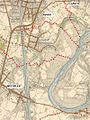
 Aftakkingskanaal naar Hasselt - Vandermaelen (no canal polyline).png 7,015 × 9,921; 128.11 MB
-
 Aftakkingskanaal naar Hasselt - Vandermaelen.png 7,015 × 9,921; 127.46 MB
-
 Baerten 4 counties of Hesbaye.png 1,086 × 730; 58 KB
-
 Belgielimburg.png 398 × 335; 6 KB
-
 Belgien Luxemburg Limburg Deutscher Bund dt.png 620 × 206; 59 KB
-
 Belgien Luxemburg Limburg Deutscher Bund.png 620 × 206; 50 KB
-
 Belgium Limburg location map.svg 433 × 472; 40 KB
-
 BelgiumLimburg.png 398 × 335; 7 KB
-
 Carte du siége de Maestricht (1748), RAL K 226 1.jpg 17,351 × 12,462; 36.32 MB
-
 DialectenLimburgBelgie.png 948 × 936; 522 KB
-
 Hvznl.jpg 1,600 × 1,600; 150 KB
-
 Kaart Maastricht en omgeving, 1748 (RAL K 045).jpg 7,895 × 6,387; 30.41 MB
-
 Kaart van Brabant, Jacob Bos, naar Jacob van Deventer, 1558.jpg 1,167 × 703; 318 KB
-
 Keizelboomgaard.JPG 1,536 × 2,048; 223 KB
-
 Kempen-Aachen concessions nl.png 2,675 × 1,838; 3.85 MB
-
 Kempensplateau.jpg 850 × 787; 395 KB
-
 Limburg deelgemeenten.png 972 × 956; 475 KB
-
 Limburg grenswijzigingen 20ste eeuw.svg 512 × 438; 402 KB
-
 Limburgbevolkingsdichtheid.PNG 474 × 376; 17 KB
-
 LimburgBGemeenten2022.png 270 × 203; 12 KB
-
 LimburgBGemeenten2023.png 270 × 203; 11 KB
-
 Limburgfinsepistes.png 186 × 197; 5 KB
-
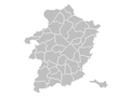
 Limburggrenzen.svg 1,301 × 1,721; 61 KB
-
 LimburgTeilung1839.svg 524 × 765; 79 KB
-
 Loon on modern borders.png 1,040 × 1,488; 90 KB
-
 Map Limburg (Belgium).svg 470 × 520; 55 KB
-
 Medieval Hesbaye.png 844 × 537; 177 KB
-
 MiddenLimburgkernen.jpg 886 × 733; 121 KB
-
 Nationaal Landschap Zuid-Limburg.jpg 2,133 × 1,600; 248 KB
-
 Nationaalparkhogekempen.jpg 850 × 787; 414 KB
-
 Oude kaart Maasmechelen.jpg 400 × 532; 51 KB
-
 OverpeltLocation.png 270 × 203; 5 KB
-
 Platdietsestreek.png 500 × 400; 17 KB
-
 Province do Limbork (eplaeçmint).png 270 × 135; 2 KB
-
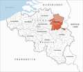
 Province of Limburg (Belgium) location.svg 1,136 × 945; 150 KB
-
 Provincie Limburg in Belgium.svg 1,136 × 988; 371 KB
-
 Provinz Limburg 2019.png 1,136 × 990; 327 KB
-
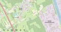 St-Lambertuskerk, Gestel, Lummen.png 2,662 × 1,408; 2.45 MB
-
 Thorn, Horn, Kessenich.PNG 589 × 560; 182 KB
-
 Westermarck-lim.png 270 × 203; 5 KB
-
 Zonhoven topografie.png 512 × 245; 101 KB


.png)


,_RAL_K_226_1.jpg)


.jpg)


.svg)


.png)
_location.svg)


