<nowiki>Category:Maps of Ense; categoría de Wikimedia; kategori Wikimedia; Wikimedia category; د ويکيمېډيا وېشنيزه; Vikimedya kategorisi; ویکیمیڈیا زمرہ; kategória projektov Wikimedia; категорія проєкту Вікімедіа; 维基媒体分类; Wikimedia-Kategorie; kategorie na projektech Wikimedia; kategorija na Wikimediji; विकिपीडिया:श्रेणी; page de catégorie de Wikimedia; kategorija na Wikimediji; विकिपीडिया वर्ग; категорија на Викимедији; Wikimedia-Kategorie; Wikimedia-kategori; kategori Wikimédia; تصنيف ويكيميديا; pajenn rummata eus Wikimedia; Wikimedia:ကဏ္ဍခွဲခြင်း; 維基媒體分類; Wikimedia категориясы; categoría de Wikimedia; categoria de Wikimedia; Викимедиа категорияһы; tudalen categori Wikimedia; Viciméid catagóir; Վիքիմեդիայի նախագծի կատեգորիա; 维基媒体分类; Wikimedia-kategori; ვიკიპედია:კატეგორიზაცია; ウィキメディアのカテゴリ; categoria Wikimedia; تصنيف بتاع ويكيميديا; විකිමීඩියා ප්රභේද පිටුව; categoria Vicimediorum; विकिमीडिया श्रेणी; Wikimedia-luokka; Wikimedia category; guruhi Vikimedia; катэгорыя ў праекце Вікімэдыя; Викимедиа проектындагы төркем; catigurìa di nu pruggettu Wikimedia; หน้าหมวดหมู่วิกิมีเดีย; Wikimedia:Kategorija; Wikimedia-Kategorie; Wikimedia:Klassys; категория на Уикимедия; categorie a unui proiect Wikimedia; categurìa 'e nu pruggette Wikimedia; Wikimedia-kategori; kawan Wikimèdia; гурӯҳи Викимедиа; 위키미디어 분류; Wikimedia-bólkur; kategorio en Vikimedio; kategori Wikimedia; Wikimedia:Ronnaghys; উইকিমিডিয়া বিষয়শ্রেণী; kategori Wikimedia; 维基媒体分类; וויקימעדיע קאַטעגאָריע; kategorija w projektach Wikimedije; thể loại Wikimedia; Wikimedia projekta kategorija; kategoria ti Wikimedia; categoria de um projeto da Wikimedia; Wikimedia category; категорияд Ангилал; Wikimedia-kategori; kategori Wikimedia; پۆلی ویکیمیدیا; Wikimedia category; Vikimédia ñemohenda; Wikimédia-kategória; વિકિપીડિયા શ્રેણી; Wikimediako kategoria; категория в проекте Викимедиа; Wikimedia-Kategorie; Kategoriya ning Wikimedia; Wikimedia-kategorie; Wîkîmediya:Kategorî; विकिमिडिया श्रेणी; Wikimedia-Kategorie; קטגוריה במיזמי ויקימדיה; Викимедиа проектындагы төркем; 維基媒體分類; विकिमिडिया श्रेणी; 维基媒体分类; Wikimedia-kategoriija; гурӯҳи Викимедиа; jamii ya Wikimedia; Wikimedia-categorie; categoría de Wikimedia; categoria di un progetto Wikimedia; Wikimedia-categorie; 维基媒体分类; Wikimedia-Kategorie; 維基媒體分類; 維基媒體分類; Wikimedia-kategory; ردهٔ ویکیپدیا; kategorya ng Wikimedia; ẹ̀ka Wikimedia; 維基媒體分類; categoria de um projeto da Wikimedia; Викимедиина категорија; Wikimedia-Kategorie; tumbung Wikimedia; விக்கிமீடியப் பகுப்பு; kategorija Wikimedie; Wikimedia proyektındağı törkem; Wikimedia-kategorie; Wikimedia-Kategorie; kategori Wikimedia; kategoria w projekcie Wikimedia; വിക്കിമീഡിയ വർഗ്ഗം; Wikimedia-categorie; kategori Wikimedia; Vikipidiya:Shopni; زمرو:وڪيپيڊيا زمرا بندي; kategori e Wikimedias; categoría de Wikimedia; Wikimedia kategooria; κατηγορία εγχειρημάτων Wikimedia; катэгорыя ў праекце Вікімедыя</nowiki>

 Anröchte · Bad Sassendorf · Ense · Erwitte · Geseke · Lippetal · Lippstadt · Möhnesee · Rüthen · Soest · Warstein · Welver · Werl · Wickede (Ruhr) ·


 Bilme in Ense.svg 1,084 × 778; 19 KB
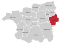 Bittingen in Ense.svg 1,084 × 778; 19 KB
 Bremen in Ense.svg 1,084 × 778; 17 KB
 Ense in SO.svg 580 × 395; 289 KB
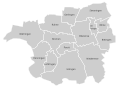 Ense subdivisions.svg 1,084 × 778; 19 KB
 Gerlingen in Ense.svg 1,084 × 778; 17 KB
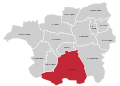 Höingen in Ense.svg 1,084 × 778; 17 KB
 Hünningen in Ense.svg 1,084 × 778; 19 KB
 Lüttringen in Ense.svg 1,084 × 778; 17 KB
 Niederense in Ense.svg 1,084 × 778; 19 KB
 Oberense in Ense.svg 1,084 × 778; 17 KB
 Parsit in Ense.svg 1,084 × 778; 17 KB
 Ruhne in Ense.svg 1,084 × 778; 17 KB
 Sieveringen in Ense.svg 1,084 × 778; 17 KB
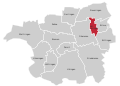 Volbringen in Ense.svg 1,084 × 778; 19 KB
 Waltringen in Ense.svg 1,084 × 778; 17 KB


