Category:Maps of East Dunbartonshire
Jump to navigation
Jump to search
Council areas (municipalities) of Scotland: Aberdeen · Aberdeenshire · Angus · Argyll and Bute · Clackmannanshire · Dumfries and Galloway · Dundee · East Ayrshire · East Dunbartonshire · East Lothian · East Renfrewshire · Edinburgh · Falkirk · Fife · Glasgow · Highland · Inverclyde · Midlothian · Moray · North Ayrshire · North Lanarkshire · Outer Hebrides · Orkney Islands · Perth and Kinross · Renfrewshire · Scottish Borders · Shetland Islands · South Ayrshire · South Lanarkshire · Stirling · West Dunbartonshire · West Lothian
Wikimedia category | |||||
| Upload media | |||||
| Instance of | |||||
|---|---|---|---|---|---|
| Category combines topics | |||||
| East Dunbartonshire | |||||
council area in Scotland    | |||||
| Instance of | |||||
| Part of |
| ||||
| Location | Scotland | ||||
| Capital | |||||
| Legislative body |
| ||||
| Population |
| ||||
| Area |
| ||||
| official website | |||||
 | |||||
Subcategories
This category has only the following subcategory.
W
- Wards of East Dunbartonshire (9 F)
Media in category "Maps of East Dunbartonshire"
The following 19 files are in this category, out of 19 total.
-
 BearsdenExpansion.svg 1,990 × 1,696; 187 KB
-
 BearsdenMap1923.jpg 808 × 677; 113 KB
-
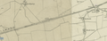 Cadder Yard map 1843-1882.png 1,465 × 561; 1.32 MB
-
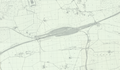 Cadder Yard Map circa 1960.png 1,099 × 639; 569 KB
-
 East Dunbartonshire council.PNG 2,733 × 3,411; 207 KB
-
 East Dunbartonshire UK blank map.svg 1,425 × 1,279; 670 KB
-
 East Dunbartonshire UK location map.svg 1,425 × 1,279; 834 KB
-
 East Dunbartonshire UK parish map (blank).svg 1,425 × 1,279; 746 KB
-
 East Dunbartonshire UK relief location map.jpg 2,003 × 1,797; 337 KB
-
 East Dunbartonshire UK ward map (blank).svg 1,425 × 1,279; 756 KB
-
 East Dunbartonshire UK ward map 2017 (blank).svg 1,425 × 1,279; 729 KB
-
 East Dunbartonshire.svg 595 × 842; 50 KB
-
 Lenzie Peat Railway circa 1960.png 1,202 × 559; 1.54 MB
-
 Lenzie Peat Railway peat packing shed.png 1,295 × 557; 1.37 MB
-
 Scot1975BearMiln.png 200 × 229; 30 KB
-
 Scot1975Strathkelvin.png 200 × 229; 30 KB
-
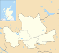
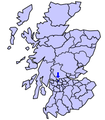
 Scotland East Dunbartonshire.png 511 × 730; 11 KB
-
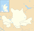
 ScotlandEastDunbartonshire.png 200 × 230; 4 KB
-
 Strathkelvin and Bearsden (Scottish Parliament constituency).svg 281 × 326; 63 KB


.svg)
.svg)
.svg)
.svg)