Category:East Dunbartonshire
Jump to navigation
Jump to search
Council areas (municipalities) of Scotland: Aberdeen · Aberdeenshire · Angus · Argyll and Bute · Clackmannanshire · Dumfries and Galloway · Dundee · East Ayrshire · East Dunbartonshire · East Lothian · East Renfrewshire · Edinburgh · Falkirk · Fife · Glasgow · Highland · Inverclyde · Midlothian · Moray · North Ayrshire · North Lanarkshire · Outer Hebrides · Orkney Islands · Perth and Kinross · Renfrewshire · Scottish Borders · Shetland Islands · South Ayrshire · South Lanarkshire · Stirling · West Dunbartonshire · West Lothian
council area in Scotland    | |||||
| Upload media | |||||
| Instance of | |||||
|---|---|---|---|---|---|
| Part of |
| ||||
| Location | Scotland | ||||
| Capital | |||||
| Legislative body |
| ||||
| Population |
| ||||
| Area |
| ||||
| official website | |||||
 | |||||
English: East Dunbartonshire is one of the 32 council areas of Scotland.

Subcategories
This category has the following 27 subcategories, out of 27 total.
A
B
E
G
H
I
N
P
S
T
Media in category "East Dunbartonshire"
The following 6 files are in this category, out of 6 total.
-
 Coat of arms of East Dunbartonshire.svg 1,066 × 1,062; 702 KB
-
 Deerdykes Roundabout (geograph 2298028).jpg 640 × 480; 200 KB
-
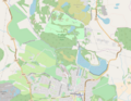 Map of Mugdock Country Park.png 914 × 711; 408 KB
-
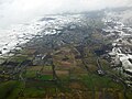 Queenzieburn and Kilsyth from the air (geograph 5308174).jpg 640 × 480; 127 KB
-
 Sunny Heatherbank.jpg 4,080 × 3,072; 5.01 MB
-
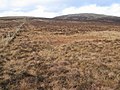 Between Owsen Hill and Little Earl - geograph.org.uk - 338492.jpg 640 × 480; 146 KB
.jpg)

.jpg)

