Category:Maps of Dry Tortugas National Park
Jump to navigation
Jump to search
United States national parks: Acadia · American Samoa · Arches · Badlands · Big Bend · Biscayne · Black Canyon of the Gunnison · Bryce Canyon · Canyonlands · Capitol Reef · Carlsbad Caverns · Channel Islands · Congaree · Crater Lake · Cuyahoga Valley · Death Valley · Denali · Dry Tortugas · Everglades · Gateway Arch · Gates of the Arctic · Glacier · Glacier Bay · Grand Canyon · Grand Teton · Great Basin · Great Smoky Mountains · Guadalupe Mountains · Haleakalā · Hawaii Volcanoes · Hot Springs · Indiana Dunes · Isle Royale · Joshua Tree · Kenai Fjords · Kings Canyon · Kobuk Valley · Lake Clark · Lassen Volcanic · Mammoth Cave · Mesa Verde · Mount Rainier · North Cascades · Olympic · Petrified Forest · Pinnacles · Redwood · Rocky Mountain · Saguaro · Sequoia · Shenandoah · Theodore Roosevelt · Virgin Islands · Voyageurs · White Sands · Wind Cave · Wrangell-St. Elias · Yellowstone · Yosemite · Zion
English: Maps of Dry Tortugas National Park
Wikimedia category | |||||
| Upload media | |||||
| Instance of | |||||
|---|---|---|---|---|---|
| Category combines topics | |||||
| Dry Tortugas National Park | |||||
64,657 acres in Florida (US) managed by the National Park Service  | |||||
| Instance of | |||||
| Part of |
| ||||
| Location | Monroe County, Florida | ||||
| Operator | |||||
| Heritage designation |
| ||||
| IUCN protected areas category | |||||
| Inception |
| ||||
| Area |
| ||||
| Visitors per year |
| ||||
| official website | |||||
 | |||||
Subcategories
This category has the following 2 subcategories, out of 2 total.
Media in category "Maps of Dry Tortugas National Park"
The following 17 files are in this category, out of 17 total.
-
 Dry tortugas inset94-garden key.jpg 593 × 827; 223 KB
-
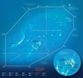
 Dry Tortugas National Park.svg 1,000 × 1,000; 2 KB
-
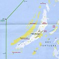
 Dry tortugas np big.gif 600 × 848; 41 KB
-
 Dry Tortugas50.jpg 7,178 × 6,299; 8.16 MB
-
 Dry tortugas94.jpg 2,452 × 2,061; 1.43 MB
-
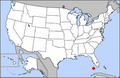 LocMap Dry Tortugas National Park.png 280 × 183; 31 KB
-
 Loggerhead Key map.jpg 1,347 × 1,330; 686 KB
-
 NPS dry-tortugas-bird-key-wreck-map.jpg 1,536 × 1,128; 102 KB
-
 NPS dry-tortugas-camping-map.jpg 1,096 × 1,124; 115 KB
-
 NPS dry-tortugas-detail-map.jpg 1,259 × 1,187; 170 KB
-
 NPS dry-tortugas-fishing-map.jpg 1,056 × 1,164; 129 KB
-
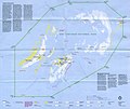
 NPS dry-tortugas-map.jpg 2,485 × 2,345; 557 KB
-
 NPS dry-tortugas-map.pdf 2,485 × 2,345; 806 KB
-
 NPS dry-tortugas-nautical-chart.pdf 1,275 × 1,650, 16 pages; 4.31 MB
-
 NPS dry-tortugas-topo-map.jpg 3,765 × 3,916; 6.95 MB
-
 Tortugas Bank.gif 455 × 439; 19 KB
-
 Tortugas Keys Reservation EO 779 illustration.jpg 1,997 × 2,874; 664 KB


