Category:Maps of Azerbaijani-inhabited regions
Jump to navigation
Jump to search
Subcategories
This category has the following 3 subcategories, out of 3 total.
Media in category "Maps of Azerbaijani-inhabited regions"
The following 31 files are in this category, out of 31 total.
-
 Administrative map of Elisabethpol Governorate-1902.png 4,956 × 3,456; 13.19 MB
-
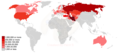 Azerbaijani diaspora map.png 1,425 × 625; 144 KB
-
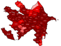 Azerbaijani Turks by 2009 census.png 2,082 × 1,584; 218 KB
-
 Caucasus-ethnic azeri.png 1,088 × 864; 212 KB
-
 DistributionOfAzerbaijanisMap.png 1,594 × 1,370; 341 KB
-
 Ethnographic map of the Akhalkalaki uyezd-1902.jpg 1,031 × 937; 186 KB
-
 Ethnographic map of the Akhaltsikhe uyezd-1902.jpg 1,153 × 915; 174 KB
-
 Ethnographic map of the Ardahan Okrug-1902.png 1,174 × 1,270; 1.95 MB
-
 Ethnographic map of the Erivan Governorate-1902.png 4,956 × 3,376; 13.86 MB
-
 Ethnographic map of the Kaghizman Okrug-1902.png 1,450 × 812; 1.61 MB
-
 Ethnographic map of the Kars Oblast (1902)-map legend-1.png 757 × 686; 433 KB
-
 Ethnographic map of the Kars Oblast (1902)-map legend-2.png 815 × 231; 153 KB
-
 Ethnographic map of the Kars Oblast-1902 - clipped.png 2,082 × 2,275; 5.31 MB
-
 Ethnographic map of the Kars Oblast-1902.png 4,956 × 3,361; 11.57 MB
-
 Ethnographic map of the Kars Okrug-1902.png 1,350 × 1,173; 2.35 MB
-
 Ethnographic map of the Oltu Okrug-1902.png 829 × 843; 985 KB
-
 Ethnographic map of the Signakhi uyezd-1902.jpg 1,602 × 1,754; 607 KB
-
 Ethnographic map of the Tiflis Governorate (1902)-map legend-1.jpg 928 × 1,211; 179 KB
-
 Ethnographic map of the Tiflis Governorate (1902)-map legend-2.jpg 1,105 × 392; 73 KB
-
 Ethnographic map of the Tiflis Governorate (1902)-map legend-3.jpg 949 × 270; 98 KB
-
 Ethnographic map of the Tiflis uyezd-1902.jpg 1,617 × 962; 334 KB
-
 Historical lands of Azerbaijan 2.jpg 240 × 359; 28 KB
-
 Map-etno-tiflis.jpg 5,900 × 3,400; 3.77 MB
-
 Whole Azerbaijan map.PNG 442 × 500; 206 KB
-
 Карта театра войны с персиянами 1827.jpg 8,520 × 6,773; 14.72 MB
-
-
 Этнографическая карта Елизаветопольского уезда (1880 г.).jpg 1,284 × 1,429; 1.8 MB
-
 Этнографическая карта Карсской области (1880 г.).jpg 1,711 × 1,768; 925 KB
-
 Этнографическая карта Ленкоранского уезда (1880 г.).jpg 941 × 1,194; 310 KB
-
 Этнографическая карта Сигнахского уезда (1880 г.).jpg 1,326 × 1,198; 516 KB
-
 Этнографическая карта Тифлисского уезда (1880 г.).jpg 1,529 × 1,249; 657 KB


-map_legend-1.png)


-map_legend-1.jpg)


.jpg)
.jpg)
.jpg)
.jpg)
.jpg)
-map_legend-2.png)
-map_legend-2.jpg)
-map_legend-3.jpg)