Category:July 2011 in the East Riding of Yorkshire
Jump to navigation
Jump to search
Ceremonial counties of England: Bedfordshire · Berkshire · Buckinghamshire · Cambridgeshire · Cheshire · Cornwall · Cumbria · Derbyshire · Devon · Dorset · Durham · East Riding of Yorkshire · East Sussex · Essex · Gloucestershire · Greater London · Greater Manchester · Hampshire · Herefordshire · Hertfordshire · Isle of Wight · Kent · Lancashire · Leicestershire · Lincolnshire · Merseyside · Norfolk · North Yorkshire · Northamptonshire · Northumberland · Nottinghamshire · Oxfordshire · Rutland · Shropshire · Somerset · South Yorkshire · Staffordshire · Suffolk · Surrey · Tyne and Wear · West Midlands · West Sussex · West Yorkshire · Wiltshire · Worcestershire
City-counties: Bristol ·
Former historic counties:
Other former counties:
City-counties: Bristol ·
Former historic counties:
Other former counties:
Deutsch: Bilder, die im Juli 2011 in the East Riding of Yorkshire aufgenommen worden sind. Bitte beachten Sie, dass dies weder das Datum des Uploads noch das Datum des Scannens eines Fotos ist.
English: Images/pictures taken in the East Riding of Yorkshire during July 2011. Note this is not the date of the upload, nor the date a photo was scanned.
Español: Fotografías o imágenes tomadas en the East Riding of Yorkshire durante julio 2011. No es la fecha de subida ni escaneo, sino la fecha en que las fotografías o imágenes se crearon.
Esperanto: Bildoj faritaj en the East Riding of Yorkshire en julio 2011. Tio ne estas la dato, kiam la bildoj estis alŝutitaj aŭ skanitaj.
Français : Photographies ou images prises en the East Riding of Yorkshire durant juillet 2011. Ce n'est pas la date du téléchargement ou du scan.
Galego: Fotografías ou imaxes tomadas en the East Riding of Yorkshire durante xullo 2011. Non é a data de subida nin escaneamento, senón a data na que se crearon as fotografías ou imaxes.
Italiano: Fotografie o immagini scattate a the East Riding of Yorkshire nel luglio 2011. Nota bene: la data non si riferisce né a quella di upload né a quella in cui la foto è stata digitalizzata.
Norsk bokmål: Bilder tatt i the East Riding of Yorkshire i løpet av juli 2011. Merk at dette ikke er datoen for opplasting, eller når et bilde har blitt skannet.
Norsk nynorsk: Bilete teke i the East Riding of Yorkshire i løpet av juli 2011. Merk at dette ikkje er datoen for opplasting, eller når eit bilete har vorte skanna.
Русский: Изображения, сделанные в the East Riding of Yorkshire в течение июль 2011 (не дата загрузки изображения).
Українська: Зображення, зроблені в the East Riding of Yorkshire протягом липень 2011. Зауважте, що це не дата завантаження чи дата сканування фотографії.
| July 2010 | ← | July 2011 | → | July 2012 | |||||||
| Jan | Feb | Mar | Apr | May | Jun | Jul | Aug | Sep | Oct | Nov | Dec |
| 16 | 29 | 82 | 46 | 84 | 30 | 58 | 28 | 28 | 51 | 50 | 43 |
|---|---|---|---|---|---|---|---|---|---|---|---|
Subcategories
This category has only the following subcategory.
Media in category "July 2011 in the East Riding of Yorkshire"
The following 57 files are in this category, out of 57 total.
-
 A bridleway near Loftsome Bridge (geograph 2509970).jpg 800 × 600; 225 KB
-
-
 Bay Horse - Main Street (geograph 2530049).jpg 640 × 480; 62 KB
-
 Bempton Lane north of Bridlington - geograph.org.uk - 2498788.jpg 800 × 600; 296 KB
-
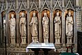 Beverley Minster Screen 1.jpg 1,024 × 685; 378 KB
-
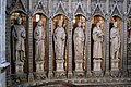 Beverley Minster Screen 2.jpg 1,024 × 685; 439 KB
-
 Beverley Organ Casing Carving 1.jpg 300 × 448; 60 KB
-
 Beverley Organ Casing Carving 2.jpg 156 × 448; 51 KB
-
 Beverley Organ Casing Carving 3.jpg 289 × 448; 62 KB
-
 Bridge Rolls - Square (geograph 2530037).jpg 480 × 640; 88 KB
-
 Chris Clubley Estate Agents - Square (geograph 2530031).jpg 480 × 640; 90 KB
-
 Cottingham Day 2011 IMG 1960 - panoramio.jpg 799 × 1,200; 589 KB
-
 Dental Surgery - Viking Road (geograph 2529372).jpg 640 × 480; 66 KB
-

-
 Electricity Substation - Viking Rd (geograph 2529364).jpg 640 × 557; 117 KB
-
 Entering Asselby, East Yorkshire (geograph 2509948).jpg 800 × 600; 247 KB
-
 Entering Yapham Hill, East Yorkshire (geograph 2503824).jpg 800 × 600; 214 KB
-
 Fish & Chip Shop - Main Street (geograph 2530493).jpg 640 × 480; 72 KB
-
 Gas Installation - off Viking Road (geograph 2529369).jpg 640 × 480; 85 KB
-
 Homecare - Square (geograph 2530034).jpg 640 × 480; 59 KB
-
 Jack Russell - Eddi - panoramio (1).jpg 1,020 × 729; 651 KB
-
 Jack Russell - Eddi about to get wet - panoramio.jpg 1,600 × 1,143; 304 KB
-
 Jack Russell - Eddi at the Beach - panoramio.jpg 598 × 837; 441 KB
-
 Keyingham Drain, Stone Creek, East Yorks - geograph.org.uk - 2501079.jpg 640 × 426; 210 KB
-
 Main Road, Knedlington, East Yorkshire (geograph 2509944).jpg 800 × 600; 309 KB
-
 Polygonia c-album (geograph 5598100).jpg 2,816 × 2,112; 1.43 MB
-
 Port of Goole 2.jpg 1,024 × 768; 436 KB
-
 Port of Goole 3.jpg 1,024 × 768; 425 KB
-
 Port of Goole 4.jpg 1,024 × 768; 462 KB
-
 Post Office - Church Road (geograph 2530047).jpg 640 × 527; 81 KB
-
 Priestman Crane, Goole.jpg 1,024 × 768; 283 KB
-
 Priestmann Crane, Goole, next to Dutch river.JPG 3,000 × 4,000; 4.91 MB
-

-
 School - Church Road (geograph 2530560).jpg 640 × 480; 52 KB
-
 Short Lane from Bempton Lane - geograph.org.uk - 2498790.jpg 800 × 600; 245 KB
-
 St John the Baptist - Chancel (geograph 2530552).jpg 485 × 640; 64 KB
-
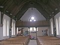
 St John the Baptist - Nave (geograph 2530550).jpg 480 × 640; 60 KB
-
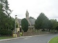
 St John the Baptist - viewed from Church Road (geograph 2530555).jpg 640 × 480; 62 KB
-
 St John the Baptist - West End (geograph 2530553).jpg 640 × 480; 59 KB
-
-
 Stamford Bridge Pharmacy - Square (geograph 2530035).jpg 640 × 480; 72 KB
-
 StamfordBridge1066.JPG 3,456 × 2,592; 3.84 MB
-
 Stone Creek, East Yorks - geograph.org.uk - 2501093.jpg 640 × 460; 194 KB
-
 Stone Creek, East Yorks, from the west - geograph.org.uk - 2501027.jpg 640 × 467; 211 KB
-
 Strensall Medical Practice - Square (geograph 2530029).jpg 640 × 480; 51 KB
-
 Take a Leaf - Square (geograph 2530033).jpg 480 × 640; 79 KB
-
 The co-operative food - Square (geograph 2530032).jpg 640 × 590; 89 KB
-
 The entrance to HM Prison, Full Sutton (geograph 2503791).jpg 800 × 600; 262 KB
-
 The entrance to Rowland Hill Farm (geograph 2503819).jpg 800 × 600; 251 KB
-
 The Pottery Craft Centre - Square (geograph 2530030).jpg 480 × 640; 95 KB
-
 The Stamford - Square (geograph 2530044).jpg 640 × 480; 54 KB
-
 Towards Stone Creek Farm, East Yorks - geograph.org.uk - 2501105.jpg 640 × 426; 201 KB
-
 Vic Sutton Memorial Road Race 2011 (5900738126).jpg 710 × 1,000; 245 KB
-
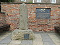
 War Memorial - St John the Baptist Church (geograph 2530512).jpg 413 × 640; 56 KB
-
 Weedleytunneljuly2011.jpg 400 × 300; 121 KB
-
 Wesleyan Chapel - viewed from Viking Road (geograph 2529376).jpg 640 × 480; 63 KB
-
 Yapham Road towards Pocklington (geograph 2503831).jpg 800 × 600; 182 KB
.jpg)
.jpg)
.jpg)


.jpg)
.jpg)

.jpg)

.jpg)
.jpg)
.jpg)
.jpg)
.jpg)
.jpg)
.jpg)


.jpg)
.jpg)


.jpg)


.jpg)

.jpg)
.jpg)
.jpg)
.jpg)
.jpg)
.jpg)


.jpg)
.jpg)
.jpg)
.jpg)
.jpg)
.jpg)
.jpg)

.jpg)
.jpg)

.jpg)
.jpg)