Category:20th-century maps of England
Jump to navigation
Jump to search
Subcategories
This category has the following 11 subcategories, out of 11 total.
- 1960s maps of England (10 F)
- 1970s maps of England (4 F)
- 1980s maps of England (9 F)
- 1990s maps of England (8 F)
L
Media in category "20th-century maps of England"
The following 5 files are in this category, out of 5 total.
-
 Adforton.PNG 1,023 × 805; 2.09 MB
-
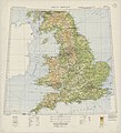 Ordnance Survey Great Britain Sheet 2, Published 1933.jpg 12,412 × 13,632; 40.67 MB
-
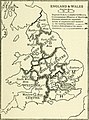
 The future of local government (1921) (14781794612).jpg 1,512 × 2,052; 386 KB
-
 The future of local government (1921) (14781797602).jpg 1,416 × 1,904; 290 KB
-
 Upton1918.png 700 × 481; 63 KB


_(14781794612).jpg)
_(14781797602).jpg)
