Category:1920s maps of England
Jump to navigation
Jump to search
Media in category "1920s maps of England"
The following 7 files are in this category, out of 7 total.
-
-

-
 Ordnance Survey One-Inch Sheet 117 East Kent, Published 1920.jpg 8,603 × 12,090; 35.28 MB
-
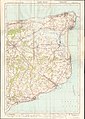
 Ordnance Survey One-Inch Sheet 64 Peterborough, Published 1922.jpg 11,915 × 8,865; 10.05 MB
-
 Ordnance Survey One-Inch Tourist Map of Country Round London, Published 1921.jpg 15,484 × 12,002; 27.13 MB
-
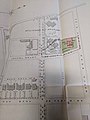
 Plan of Durovernum.jpg 1,447 × 1,749; 856 KB
-
 Plan of Durovernum.png 2,893 × 3,498; 1.62 MB


