Category:1976 United States Senate election maps
Jump to navigation
Jump to search
Media in category "1976 United States Senate election maps"
The following 47 files are in this category, out of 47 total.
-
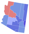 1976 Arizona.png 2,000 × 2,332; 214 KB
-
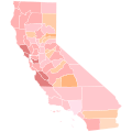
 1976 California Senate Counties.png 2,726 × 4,275; 723 KB
-

-

-

-
-

-

-

-

-
 1976 United States Senate election in Hawaii results map by county.svg 1,052 × 614; 2.12 MB
-

-

-
 1976 United States Senate election in Maryland results map by county.svg 744 × 405; 222 KB
-
 1976 United States Senate Election in Massachusetts by Town.svg 810 × 502; 182 KB
-
 1976 United States Senate election in Massachusetts results map by municipality.svg 2,100 × 1,300; 1.57 MB
-
 1976 United States Senate election in Michigan results map by county.svg 744 × 744; 309 KB
-

-

-

-
 1976 United States Senate election in Montana results map by county.svg 800 × 463; 1.34 MB
-

-

-

-

-

-
 1976 United States Senate election in Ohio results map by county.svg 810 × 810; 39 KB
-

-

-

-

-

-
 1976 United States Senate election in Utah results map by county.svg 810 × 810; 29 KB
-

-
 1976 United States Senate election in Virginia results map by county.svg 335 × 165; 577 KB
-

-

-

-

-
 1976 US Senate election in Massachusetts Democratic primary results by municipality.svg 2,100 × 1,300; 1.58 MB
-
 1976 virginia senate election map.png 833 × 364; 34 KB
-
 Minnesota senate election, 1976 American Party.svg 512 × 574; 40 KB
-
 New York 1976 Senate Election.gif 342 × 263; 7 KB
-
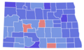 North Dakota Senate Election Results by County, 1976.png 2,000 × 1,194; 171 KB
-
 Ohio 1976 Senate Race.gif 198 × 214; 7 KB
-
 US Senate 1976 Delaware by State House District.svg 485 × 760; 203 KB
-
 Virginia Senate Election Results by County, 1976.svg 810 × 358; 88 KB


