Category:1910s maps of Japan
Jump to navigation
Jump to search
Countries of Asia: Afghanistan · Armenia‡ · Azerbaijan‡ · Cambodia · People's Republic of China · Cyprus‡ · Egypt‡ · Georgia‡ · India · Indonesia‡ · Iran · Iraq · Japan · Jordan · Lebanon · Myanmar · Philippines · Russia‡ · Syria · Turkey‡
Limited recognition: Abkhazia‡ · Taiwan · State of Palestine
‡: partly located in Asia
Limited recognition: Abkhazia‡ · Taiwan · State of Palestine
‡: partly located in Asia
Subcategories
This category has the following 3 subcategories, out of 3 total.
- 1913 maps of Japan (1 F)
Media in category "1910s maps of Japan"
The following 8 files are in this category, out of 8 total.
-
 Empire-of-Japan-Topographic-Map-大日本帝国の地形図-1918.jpg 8,922 × 6,522; 23.47 MB
-
 1918 Japanese propaganda map of World War I and the Russo-Japanese War.jpg 4,414 × 9,000; 12.99 MB
-
 1918 Toppan Printing Co. Map of Japanese Railways.png 6,668 × 8,999; 102.03 MB
-
 Tokyo 1919.JPG 1,042 × 1,387; 596 KB
-
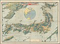
 Chinese Empire, and Japan (1910).jpg 14,754 × 12,399; 33.5 MB
-
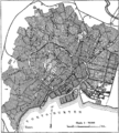 Karta över Tokyo, Nordisk familjebok.png 1,028 × 1,138; 191 KB
-
 Seeing our missions across the seas (1918) (14589780498).jpg 2,000 × 1,814; 734 KB
-
 The Times history of the war (1914) (14596745018).jpg 1,790 × 3,023; 1.08 MB


.jpg)

_(14589780498).jpg)
_(14596745018).jpg)