Category:1880s maps of England
Jump to navigation
Jump to search
Subcategories
This category has the following 3 subcategories, out of 3 total.
L
T
Media in category "1880s maps of England"
The following 53 files are in this category, out of 53 total.
-
 134 of 'The History of the Parish and Manor of Wokey, etc' (11184902826).jpg 1,421 × 2,256; 287 KB
-

-
 The earth and its inhabitants (1881) (14597776077).jpg 1,828 × 1,884; 628 KB
-
 The earth and its inhabitants (1881) (14597815487).jpg 1,926 × 1,432; 512 KB
-

-

-

-

-

-

-

-
-
 Carmarthenshire boundaries map 1885.jpg 3,786 × 3,144; 1.39 MB
-
 135 of 'The History of the Parish and Manor of Wokey, etc' (11185512813).jpg 1,439 × 2,285; 250 KB
-
 39 of 'The History of the Parish and Manor of Wokey, etc' (11183651474).jpg 1,413 × 2,349; 286 KB
-

-
 Willersley and Winforton Herefordshire OS Sheet XXIV.SE, Surveyed and published 1886.jpg 4,672 × 3,292; 5.87 MB
-
 20 of 'Stephenson's New Guide to Southport ... With a map, etc' (11189948925).jpg 5,614 × 3,994; 3.65 MB
-

-
 20 of 'Ingleton- bygone and present. (With a map and illustrations.)' (11194677156).jpg 4,604 × 4,146; 3.38 MB
-

-

-

-

-
-

-
 218 of 'Physiography ... New edition' (11168596555).jpg 1,936 × 1,245; 482 KB
-

-
 326 of 'Physiography ... New edition' (11173078126).jpg 1,377 × 2,004; 668 KB
-

-
 83 of 'Physiography ... New edition' (11166346706).jpg 1,417 × 2,089; 615 KB
-
 Bodleian Libraries, Drink Map of Oxford 1883.jpg 1,000 × 675; 77 KB
-
-
 Bodleian Libraries, Oxfordshire sheet XXXIII, 1876.jpg 1,000 × 675; 135 KB
-
 Geological map Northumberland Durham Lebour 1886.png 4,473 × 5,315; 4.11 MB
-

-

-
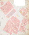
 Insurance Plan of Sheffield (1888); Key Plan (BL 149994).tiff 3,131 × 3,736; 33.47 MB
-
 Insurance Plan of Sheffield (1888); sheet 2 (BL 149995).tiff 3,122 × 3,729; 33.31 MB
-
 Insurance Plan of Sheffield (1888); sheet 3-1 (BL 149998).tiff 1,105 × 605; 1.91 MB
-
 Insurance Plan of Sheffield (1888); sheet 3-2 (BL 149999).tiff 3,140 × 3,741; 33.61 MB
-
 Insurance Plan of Sheffield (1888); sheet 4 (BL 150000).tiff 3,140 × 3,758; 33.76 MB
-
 Insurance Plan of Sheffield (1888); sheet 5 (BL 150001).tiff 3,152 × 3,741; 33.74 MB
-
 Insurance Plan of Sheffield (1888); sheet 6 (BL 150002).tiff 3,134 × 3,740; 33.53 MB
-
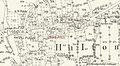 Map Hilton nearDerby 1881.jpg 2,500 × 1,365; 491 KB
-
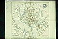
 Map of Cambridge, England (1886).png 1,219 × 625; 1.37 MB
-

-

-

-

-

-
 The earth and its inhabitants (1882) (14586681757).jpg 1,896 × 2,558; 450 KB
-
 WestmorlandBrit3.PNG 698 × 491; 19 KB
.jpg)
%27_(11178410685).jpg)
_(14597776077).jpg)
_(14597815487).jpg)
.jpg)
.jpg)
.jpg)
.jpg)
%27_(11166036963).jpg)
.jpg)
%27_(11176141203).jpg)
%27_(11178021063).jpg)

.jpg)
.jpg)
.jpg)

.jpg)
.jpg)
%27_(11194677156).jpg)
.jpg)
.jpg)
.jpg)
.jpg)
.jpg)
_p109_-_Map_of_Cornwall_to_show_the_position_of_its_Mineral_Veins_or_Lodes.jpg)
.jpg)
.jpg)
.jpg)
.jpg)
.jpg)


.jpg)
.jpg)

.png)
_(14592341848).jpg)
_(14592362219).jpg)
_(14775904311).jpg)
_(14776812114).jpg)
_(14778611432).jpg)
_(14586681757).jpg)
