Category:1870s maps of England
Jump to navigation
Jump to search
Subcategories
This category has the following 2 subcategories, out of 2 total.
L
- 1870s maps of London (52 F)
Media in category "1870s maps of England"
The following 35 files are in this category, out of 35 total.
-

-

-
-
-

-
 ELLIOT(1875) p145 - Plate IX. Souter Point, chart of vicinity.jpg 1,448 × 2,404; 2.23 MB
-
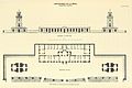
 ELLIOT(1875) p075 - Plate I. South Foreland, general plan of light-houses.jpg 1,904 × 1,398; 1.28 MB
-
 ELLIOT(1875) p079 - Plate II. South Foreland, ground-plan of engine-house.jpg 1,910 × 1,342; 1.15 MB
-
 ELLIOT(1875) p125 - Plate VI. Haishorough, general plan.jpg 1,882 × 1,402; 1.05 MB
-
 ELLIOT(1875) p167 - Plate XVI. Coquet Island, chart of vicinity.jpg 1,448 × 2,310; 1.88 MB
-
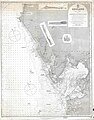
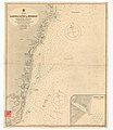
 ELLIOT(1875) p189 - Plate XX. Land's End, chart of vicinity.jpg 1,534 × 2,430; 2.17 MB
-
 ELLIOT(1875) p301 - Plate XXXVII. LaHave, elevation and general plan.jpg 2,220 × 1,484; 1.41 MB
-

-

-

-

-
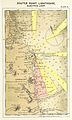
 Vinehall Street, East Sussex OS Sussex Sheet XLIII 1878.jpg 1,555 × 880; 1.2 MB
-

-

-
 59 of 'History of the English People ... With ... maps' (11119573706).jpg 2,016 × 1,450; 588 KB
-

-
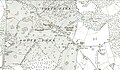
 A Map of the borough of Northampton, corrected to january 1878... - btv1b84390295.jpg 8,782 × 8,179; 8.52 MB
-
-

-
 Birmingham Improvement Scheme map - circa 1876.jpg 3,999 × 1,998; 1.07 MB
-
 Bodleian Libraries, Oxford Local Board Plan of Main and Street Drainage.jpg 1,000 × 675; 81 KB
-
-

-
 EB9 - Plan of Canterbury.png 1,263 × 1,593; 524 KB
-
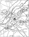
 Kitwood map 1870.png 786 × 375; 406 KB
-
 Lilian Lancaster England map.jpg 1,405 × 2,000; 294 KB
-
 OS map of Canterbury 1874.jpg 2,338 × 1,682; 2.78 MB
-

-
 The Quarterly journal of the Geological Society of London (12734128044).jpg 1,329 × 1,399; 308 KB
-
 The Quarterly journal of the Geological Society of London (12736125113).jpg 3,200 × 1,866; 1.05 MB
%27_(11129843693).jpg)


)%27_(11109148994).jpg)
_p145_-_Plate_IX._Souter_Point,_chart_of_vicinity.jpg)
_p075_-_Plate_I._South_Foreland,_general_plan_of_light-houses.jpg)
_p079_-_Plate_II._South_Foreland,_ground-plan_of_engine-house.jpg)
_p125_-_Plate_VI._Haishorough,_general_plan.jpg)
_p167_-_Plate_XVI._Coquet_Island,_chart_of_vicinity.jpg)
_p189_-_Plate_XX._Land%27s_End,_chart_of_vicinity.jpg)
_p301_-_Plate_XXXVII._LaHave,_elevation_and_general_plan.jpg)
.jpg)
%27_(11120321114).jpg)
.jpg)
%27_(11125970873).jpg)


.jpg)
.jpg)
.jpg)


.jpg)
.jpg)
.jpg)