Category:1862 maps
Jump to navigation
Jump to search
| ← · 1860 · 1861 · 1862 · 1863 · 1864 · 1865 · 1866 · 1867 · 1868 · 1869 · → |
Deutsch: Karten mit Bezug zum Jahr 1862
English: Maps related to the year 1862
Español: Mapas relativos al año 1862
Français : Cartes concernant l’an 1862
Русский: Карты 1862 года

Subcategories
This category has the following 11 subcategories, out of 11 total.
Media in category "1862 maps"
The following 178 files are in this category, out of 178 total.
-
-
 GIBBON(1862) p1.457 MAP OF THE EASTERN PART OF THE ROMAN EMPIRE.jpg 4,587 × 3,877; 8.93 MB
-
 GIBBON(1862) p2.447 CONSTANTINOPLE.jpg 2,289 × 1,439; 1.38 MB
-
 GIBBON(1862) p3.008 WESTERN ASIA.jpg 2,897 × 2,049; 2.93 MB
-
 GIBBON(1862) p5.433 THE EASTERN ROMAN EMPIRE.jpg 4,737 × 2,983; 7.01 MB
-
 GIBBON(1862) p6.008 THE MAHOMETAN EMPIRE.jpg 4,911 × 2,383; 5.58 MB
-
 GIBBON(1862) p6.445 EUROPE AT THE TIME OF CHARLEMAGNE.jpg 4,555 × 3,481; 6.88 MB
-
 GIBBON(1862) p7.008 MAP OF THE CRUSADES.jpg 3,949 × 2,315; 4.7 MB
-
 MASSELIN(1862) p104 PLAN D' ENSEMBLE DES ENVIRONS DE LONGWOOD.jpg 2,384 × 1,357; 248 KB
-
 MASSELIN(1862) p116 PLAN DE DOMAINE IMPÉRIAL LONGWOOD OLD-HOUSE.jpg 1,505 × 2,019; 334 KB
-

-

-
 1862 Johnson Map of the Roman Empire - Geographicus - RomanEmpire-johnson-1862.jpg 4,000 × 2,603; 3.19 MB
-
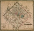
 1862 Johnson Map of Washington D.C. and Georgetown - Geographicus - WashDC-johnson-1862.jpg 4,000 × 3,249; 4.16 MB
-
 A scan of a small section of an 1862 map.jpg 5,200 × 3,267; 6.07 MB
-
 Abekawa-dōri sanchū ichien ezu LOC 80691927.jpg 12,674 × 6,656; 7.46 MB
-
 Abekawa-dōri sanchū ichien ezu LOC 80691927.tif 12,674 × 6,656; 241.35 MB
-
 Admiralty Chart No 377 A Survey of St. Lucea, Branco & Raza, Published 1823.jpg 3,824 × 2,969; 2.85 MB
-
 Adolf Eltzner, Vue genérale de Jérusalem historique et moderne (FL6881077 2368057).jpg 2,920 × 2,095; 4.77 MB
-
 Alexandre Vuillemin, Province D'Alger (FL13727074 2497183).jpg 5,580 × 7,741; 70.5 MB
-

-

-

-
 Carte routière du département du Jura.jpg 7,856 × 9,520; 9.9 MB
-
-
 Chesapeake Bay LOC 2017588252.jpg 5,656 × 4,816; 5.62 MB
-
 Civil War sketch book - Tennessee and Kentucky LOC 86675210.jpg 5,974 × 5,870; 3.54 MB
-
 Civil War sketch book - Tennessee and Kentucky LOC 86675210.tif 5,974 × 5,870; 100.33 MB
-

-
 Galveston, Texas, showing the fortifications etc. LOC 86691333.jpg 5,897 × 4,452; 2.58 MB
-
-
 Gray, F. J. (Franklin John), Saida (FL167468805 2553436).jpg 12,270 × 16,390; 209.26 MB
-

-
 Kankai kōro shinzu LOC 2013588000.jpg 21,350 × 11,900; 39.05 MB
-
 Kankai kōro shinzu LOC 2013588000.tif 21,350 × 11,900; 726.89 MB
-
 Kentucky and Tennessee LOC 2006636271.jpg 8,142 × 5,844; 6.76 MB
-
 Kentucky and Tennessee LOC 2006636271.tif 8,142 × 5,844; 136.13 MB
-
 Klein-Glienicke Parkplan Kraatz 1862.jpg 4,070 × 4,724; 5.53 MB
-
 Klein-Glienicke Ufer-Höhenwegspartie.jpg 1,524 × 1,766; 874 KB
-

-
 Lloyd's official map of the State of Tennessee LOC 2018593010.jpg 14,379 × 9,696; 23.66 MB
-

-

-
 Map of Charleston and vicinity. LOC 79695214.tif 6,218 × 5,473; 97.36 MB
-
 Map of Roanoke Island showing Rebel forts. LOC gvhs01.vhs00069.tif 1,752 × 2,341; 11.73 MB
-
 Map of the battle field of Shiloh, April 6 & 7, 1862 LOC 85690890.jpg 2,472 × 1,800; 679 KB
-
 Map of the battle field of Shiloh, April 6 & 7, 1862 LOC 85690890.tif 2,472 × 1,800; 12.73 MB
-

-

-
-
-

-

-

-
 Map of the early settlements of Delaware County, Penna.jpg 5,495 × 4,397; 7.79 MB
-

-

-

-

-

-
 Map of the field of Shiloh. April 6 (1862). LOC 2006636339.jpg 8,296 × 6,133; 7.53 MB
-
 Map of the field of Shiloh. April 6 (1862). LOC 2006636339.tif 8,296 × 6,133; 145.57 MB
-
 Map of the fortifications of Columbus, Ky. LOC 2008627288.jpg 11,391 × 11,501; 17.46 MB
-
 Map of the fortifications of Columbus, Ky. LOC 2008627288.tif 11,391 × 11,501; 374.82 MB
-

-

-
 Map of the position at Turner's Gap. South Mountain. LOC gvhs01.vhs00120.jpg 878 × 1,089; 209 KB
-
 Map of the position at Turner's Gap. South Mountain. LOC gvhs01.vhs00120.tif 878 × 1,089; 2.74 MB
-
 Map of the Rebel fortifications at Columbus, Ky. (5961394358).jpg 2,000 × 1,891; 2.59 MB
-
 Map of the Rebel fortifications at Columbus, Ky. LOC 2008628262.jpg 7,986 × 7,863; 6.67 MB
-
 Map of the Rebel fortifications at Columbus, Ky. LOC 2008628262.tif 7,986 × 7,863; 179.66 MB
-
 Map of the rebel fortifications at Columbus, Ky. LOC 2009581441.jpg 6,195 × 5,985; 4.29 MB
-
 Map of the rebel fortifications at Columbus, Ky. LOC 2009581441.tif 6,195 × 5,985; 106.08 MB
-
 Map of the rebel fortifications at Columbus, Ky. LOC lva0000197.jpg 6,456 × 5,913; 5.01 MB
-
 Map of the rebel fortifications at Columbus, Ky. LOC lva0000197.tif 6,456 × 5,913; 109.22 MB
-

-

-
 Map ofGalilee. Johnson's Palestine. 1862.jpg 1,692 × 1,207; 1.84 MB
-

-

-

-

-

-
-

-

-

-

-
-

-

-
 Nouvelle carte de la Palestine (FL37663595 3915613).jpg 14,232 × 20,465; 409.82 MB
-
 Novgorod 1862.jpg 8,077 × 8,759; 36.63 MB
-
 Original maps of Forts Henry & Donelson and vicinity. LOC 80691156.jpg 7,768 × 5,884; 6.33 MB
-
 Palestine divisée en XII tribus et IV provinces (FL37122015 3898748).jpg 2,716 × 3,861; 6.39 MB
-

-

-
 Plan géométral des environs de Nantes - 1862.jpg 7,703 × 5,597; 9.54 MB
-
 Plan of Battle of South Mills. Dismal Swamp Canal, N.C. LOC gvhs01.vhs00080.jpg 1,739 × 2,215; 664 KB
-
 Plan of Battle of South Mills. Dismal Swamp Canal, N.C. LOC gvhs01.vhs00080.tif 1,739 × 2,215; 11.02 MB
-

-

-

-

-

-

-
 Preliminary chart of Charleston Harbor and its approaches. LOC 99448842.tif 10,362 × 8,527; 252.79 MB
-

-

-

-

-
 Reconnaissance of the battle field at Bull Run, Va., fought July 21, 1861 (5961383872).jpg 1,564 × 2,000; 2.39 MB
-
-

-

-

-
 Revised Union battleplan for the Battle of Malvern Hill.jpg 3,594 × 5,387; 15.34 MB
-
 Serres et orangerie au jardin des plantes 1862.jpg 727 × 580; 30 KB
-
 Shinkan Yochi zenzu (14006160149).jpg 1,995 × 2,000; 1.61 MB
-

-
 Sketch H. showing the progress of the survey in section no. VIII, from 1846 to 1862. LOC 99447016.tif 10,087 × 6,010; 173.44 MB
-

-

-
 Sketch of Charleston Harbor (5121147412).jpg 1,992 × 2,000; 3.65 MB
-

-

-

-
-

-

-
-
-

-

-

-

-

-
 Sketch of vicinity of head qtrs. U.S. forces, Snows Pond, Kentuckey (sic). LOC 86691124.tif 3,073 × 4,815; 42.33 MB
-

-

-

-

-

-
 Tegernsee 1862 blatt 812.jpg 1,394 × 1,394; 479 KB
-

-

-
 The Battle of Antietam, September 17, 1862. LOC 75692102.jpg 9,514 × 5,502; 9.79 MB
-
 The Battle of Antietam, September 17, 1862. LOC 75692102.tif 9,514 × 5,502; 149.76 MB
-

-

-

-

-
 The Crystal Palace grounds.jpg 2,020 × 2,896; 2.15 MB
-
 The Holy Land in the time of Christ (FL36567423 3909075).jpg 3,198 × 4,381; 7.31 MB
-
 The Holy Land In The Time Of Samuel (FL36567409 3909071).jpg 2,065 × 3,203; 3.37 MB
-
 The locality of the great struggle (5490089206).jpg 1,524 × 2,000; 3.57 MB
-
-

-

-
 The Rebel defences (sic) of Savannah, Georgia, 1864 LOC gvhs01.vhs00276.jpg 3,705 × 1,932; 1.16 MB
-
 The Rebel defences (sic) of Savannah, Georgia, 1864 LOC gvhs01.vhs00276.tif 3,705 × 1,932; 20.48 MB
-

-
-
 Topographical map of Union County, New Jersey LOC 2012593682.jpg 17,252 × 12,638; 34.64 MB
-

-

-
 Topographical sketch of Decherd, Tennessee LOC 2007627486.jpg 2,788 × 3,568; 1.14 MB
-
 Topographical sketch of Decherd, Tennessee LOC 2007627486.tif 2,788 × 3,568; 28.46 MB
-
 Topographical sketch of the battle field of Stone River. (Dec. 31, 1862) LOC 99474138.jpg 5,980 × 5,315; 4.16 MB
-
 Topographical sketch of the battle field of Stone River. (Dec. 31, 1862) LOC 99474138.tif 5,980 × 5,315; 90.93 MB
-

-

-
 Topographical sketch of the environs of Nashville, Tennessee LOC 2007627475.jpg 4,049 × 4,994; 2.11 MB
-
 Topographical sketch of the environs of Nashville, Tennessee LOC 2007627475.tif 4,049 × 4,994; 57.85 MB
-

-

-
 Turkey, Persia Beloochistan Afghanistan and Turkestan (FL43908805 3923272).jpg 3,592 × 2,844; 6.34 MB
-


_p1.457_MAP_OF_THE_EASTERN_PART_OF_THE_ROMAN_EMPIRE.jpg)
_p2.447_CONSTANTINOPLE.jpg)
_p3.008_WESTERN_ASIA.jpg)
_p5.433_THE_EASTERN_ROMAN_EMPIRE.jpg)
_p6.008_THE_MAHOMETAN_EMPIRE.jpg)
_p6.445_EUROPE_AT_THE_TIME_OF_CHARLEMAGNE.jpg)
_p7.008_MAP_OF_THE_CRUSADES.jpg)
_p104_PLAN_D%27_ENSEMBLE_DES_ENVIRONS_DE_LONGWOOD.jpg)
_p116_PLAN_DE_DOMAINE_IMP%C3%89RIAL_LONGWOOD_OLD-HOUSE.jpg)
_p133_PLAN_DE_DOMAINE_IMP%C3%89RIAL_DE_LONGWOOD_OLD-HOUSE_DANS_SON_ETAT_ACTUEL.jpg)


.jpg)
.jpg)


,_Saida_(FL167468805_2553436).jpg)
_(14591045408).jpg)


.jpg)

.jpg)


._LOC_2006636339.jpg)


.jpg)


.jpg)


.jpg)


.jpg)
.jpg)


.jpg)


.jpg)
_on_Antietam_and_Sharpsburg_Maryland_-_Septr_16-17th_1862._LOC_gvhs01.vhs00117.jpg)


_on_Antietam_and_Sharpsburg,_Maryland._Septr_1862._LOC_gvhs01.vhs00119.jpg)
._LOC_86691124.jpg)
_LOC_99447478.jpg)

._LOC_gvhs01.vhs00116.jpg)


.jpg)
.jpg)
.jpg)
.jpg)

_of_Savannah,_Georgia,_1864_LOC_gvhs01.vhs00276.jpg)


_LOC_99474138.jpg)


.jpg)
.jpg)
.jpg)