User talk:NVergopolan
To consider
[edit]Hi NVergopolan, i made several edits to streamline your uploads. Please consider it in future. Example: [1]. Am i right, that Category:NVergopolan should be a user category? Regards, --Arnd (talk) 20:03, 29 November 2018 (UTC)
![[1]](https://commons.wikimedia.org/w/index.php?title=File%3AKoppen-Geiger_Map_EF_present.svg&type=revision&diff=329804584&oldid=329390830)
Thank you! Yes, that's was user category. --User:NVergopolan
Canada province maps?
[edit]Your climate change maps are amazing, can you please do some for individual provinces? Alex of Canada (talk) 02:03, 8 December 2018 (UTC)
- Province Maps coming up on early 2019. I would like to have them organized and easy searchable in a wiki page, do you have interest on helping with that? --User:NVergopolan
- Help? How would I do that? Edit: I would make a subpage on your wikipedia userpage. Something like "User:NVergopolan/Climate maps". You could just make it your user page yourself. Even more so, if you can, making your own website with a more fitting layout would be nice, but that would be difficult and expensive. I'd personally use a user subpage. Alex of Canada (talk) 08:30, 9 December 2018 (UTC)
- Hello, I have moved your Köppen-Geiger Climate Classification Maps to a specific user category Category:Maps by NVergopolan. If you have any questions, just contact me. Cheers. Anna (Cookie) (talk) 19:17, 3 January 2019 (UTC)
Contact with Redtitan/Adam Peterson
[edit]Depending on how much you are blocked currently, I suggest you contact Adam Peterson. He is responsible for rendering some köppen maps of similar resolution to yours. He does use a different isotherm to define ‘C’ from ‘D’ climates though (-3 C vs. 0 C). It looks like he might be using a similar dataset too. I posted this same message to your Wikipedia talk page, but I wasn’t sure where the best place to reach you was.Rigognos Molinarios (talk) 02:26, 8 January 2019 (UTC)
- Thank you for your message, Rigognos Molinarios. I'll reach out to Adam Peterson. And yes, the maps are very similar because both are based on WorldClim data. However, we did use additional datasets and stricktly followed the Koppen Geiger classification. You can check the methodological details of how the maps were compiled at https://www.nature.com/articles/sdata2018214. Cheers, --User:NVergopolan
Image size
[edit]Would it be possible for you to make a larger png format of the Canada koppen maps? I'd love to be able to zoom in more. Thanks for reading. Alex of Canada (talk) 03:45, 20 January 2019 (UTC)
- Dear Alex of Canada, at this point I don't have time to remake the maps. However, the original data at 1-km resolution is free and available for download at http://www.gloh2o.org/koppen/ you should be able to open it with some GIS software and zoom it to any level of detail you desired. Let me know if that helps! --User:NVergopolan
- Good luck. Sorry if it sounds as if I'm making demands, as those aren't my intentions. Edit: what's a good GIS software to download? I googled it, and there seem to be endless types. Alex of Canada (talk) 06:36, 22 February 2019 (UTC)
- You can start with QGIS: https://qgis.org/en/site/forusers/download.html# there are some tutorials online on how to open and visualize .tiff files --NVergopolan (talk) 15:17, 5 March 2019 (UTC)
Koppen-Geiger future maps
[edit]Hi NVergopolan,
First of all, I would like to thank you so much for the wonderfull work you've done with all the Koppen-Geiger's maps you put online. Second, I would like to know how did you do that ? Is there any website or software I can use to create my own maps ?
Regards,
Icarus Vitae Inari (talk) 23:14, 22 February 2020 (UTC)
- Dear Icarus, I am glad the maps are helpful and useful to you. The maps were created in python. But the original .tif files are available for download here, and maps can be done using any tools that read .tif files, such as arcGIS for example. — Preceding unsigned comment added by NVergopolan (talk • contribs) 19:30, 4 July 2020 (UTC)
- Dear NVergopolan, do you happen to retain the source code for the Python images? I am interested in regenerating them with a more... reduced level of border detail. --Artoria2e5 contribs 08:10, 8 January 2021 (UTC)
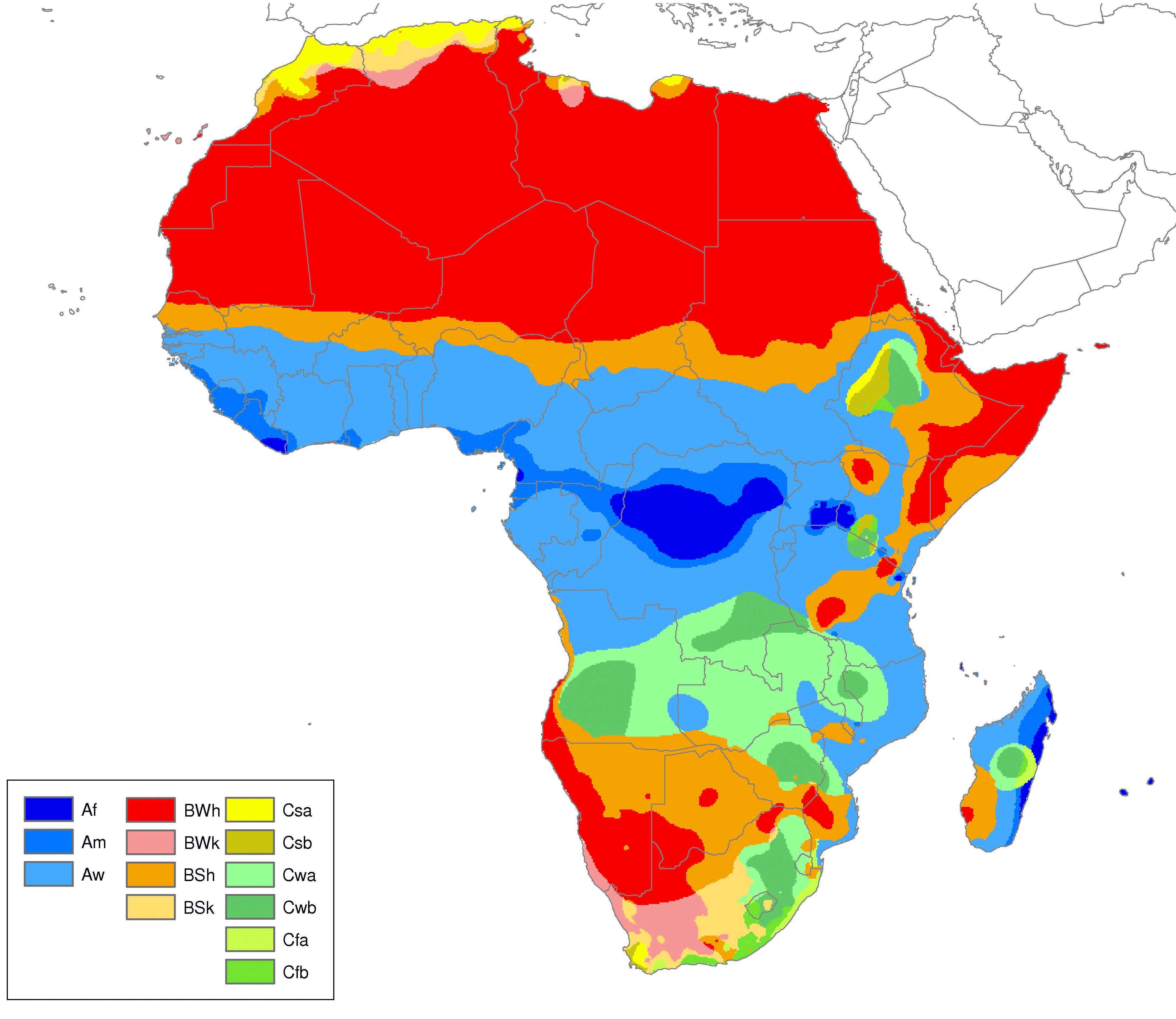
South Africa incorrect?
[edit]The areas around Cape Agulhas and Port Elizabeth have an oceanic climate but in your maps they're classified as "arid steppe"? Can't be right. — Preceding unsigned comment was added by 217.209.1.128 (talk) 17:30, 4 July 2020 (UTC)
- The maps are classified strictly following the Koppen Geiger methodology. Our results are in overall in agreement with previous studies. For instance, see Peel at al. (2007) and their map for Africa, which also identified B class type in this location. In addition, the locations you highlighted are located in between two distinct class types, which are subjected to uncertainties (see figure a)).
Somaliland
[edit]Hei, Could download Köppen–Geiger climate classification map for Somaliland.
https://commons.m.wikimedia.org/wiki/File:Somaliland_sat.jpg
https://commons.m.wikimedia.org/wiki/File:Somaliland_regions.svg
Thank you Lakmi00 (talk) 00:50, 31 December 2020 (UTC)
Koppen-Geiger Maps for Northern Europe missing the Baltic States.
[edit]I noticed the Koppen-Geiger Maps for that region you made are missing the Baltic States, even though they have both the British Isles and Nordic Countries. Can you update them to include the Baltic States as well as the British Isles and Nordic Countries? Vesperius (talk) 05:32, 29 April 2023 (UTC)
Updates for climate maps
[edit]There's an excellent resource you and your co-authors created with climate maps. Thank you for all the research you've put into it (and congrats with having published it in Nature!) At the same time, I think the community will greatly appreciate if you could update the map to reflect a changing climate. It's up to you of course but it will obviously help. (Using WP on mobile is generally pretty messy) Szmenderowiecki (talk) 23:03, 30 January 2024 (UTC)

|
Present and Future Köppen-Geiger Climate Classification Maps at 1-km resolution has been listed at Commons:Categories for discussion so that the community can discuss ways in which it should be changed. We would appreciate it if you could go to voice your opinion about this at its entry. If you created this category, please note that the fact that it has been proposed for discussion does not necessarily mean that we do not value your kind contribution. It simply means that one person believes that there is some specific problem with it. If the category is up for deletion because it has been superseded, consider the notion that although the category may be deleted, your hard work (which we all greatly appreciate) lives on in the new category. In all cases, please do not take the category discussion personally. It is never intended as such. Thank you! |