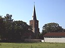
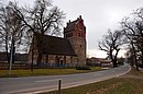
| Name
|
Location
|
Category
|
Picture
|
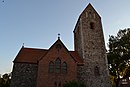
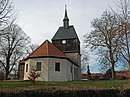
| Ahrensfelde, Dorfkirche
|
52°34′34″N 13°34′35″E / 52.576027°N 13.576307°E / 52.576027; 13.576307
|
Ahrensfelde (Brandenburg) church (empty)
|

|
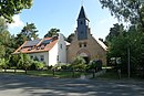
| Altenhof, Kirche
|
52°54′50″N 13°42′57″E / 52.914025°N 13.715848°E / 52.914025; 13.715848
|
Kirche Altenhof (Schorfheide) (4 F)
|

|
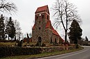
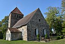
| Althüttendorf, Dorfkirche
|
52°57′46″N 13°48′25″E / 52.962680°N 13.806982°E / 52.962680; 13.806982
|
Althüttendorf church (empty)
|

|
| Basdorf, Dorfkirche
|
52°43′36″N 13°26′22″E / 52.726715°N 13.439428°E / 52.726715; 13.439428
|
Dorfkirche Basdorf (Barnim) (11 F)
|

|
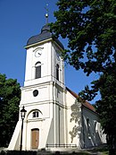
| Bernau, Marienkirche
|
52°40′47″N 13°35′14″E / 52.679722°N 13.587222°E / 52.679722; 13.587222
|
St. Marienkirche (Bernau bei Berlin) (1 C, 30 F)
|

|
| Bernau, Herz-Jesu-Kirche
|
52°40′40″N 13°35′37″E / 52.677658°N 13.593519°E / 52.677658; 13.593519
|
Herz-Jesu-Kirche (Bernau) (1 C, 14 F)
|

|
| Biesenthal, St.Marien-Kirche
|
52°46′01″N 13°38′21″E / 52.766840°N 13.639126°E / 52.766840; 13.639126
|
St. Marien (Biesenthal) (1 C, 19 F)
|

|
| Biesenthal, Stadtkirche
|
52°46′00″N 13°37′52″E / 52.766716°N 13.631197°E / 52.766716; 13.631197
|
Stadtpfarrkirche (Biesenthal im Barnim) (28 F)
|

|
| Birkholz, Dorfkirche
|
52°37′39″N 13°34′29″E / 52.627618°N 13.574839°E / 52.627618; 13.574839
|
Dorfkirche (Birkholz im Barnim) (empty)
|

|
| Blumberg, Dorfkirche
|
52°36′10″N 13°37′11″E / 52.602815°N 13.619650°E / 52.602815; 13.619650
|
Blumberg (Ahrensfelde) church (empty)
|

|
| Börnicke, Dorfkirche
|
52°39′46″N 13°38′13″E / 52.662803°N 13.637022°E / 52.662803; 13.637022
|
Dorfkirche (Börnicke bei Bernau) (empty)
|

|
| Britz, Dorfkirche
|
52°53′16″N 13°48′42″E / 52.887897°N 13.811601°E / 52.887897; 13.811601
|
Dorfkirche (Britz bei Eberswalde) (empty)
|

|
| Brodowin, Dorfkirche
|
52°54′43″N 13°57′42″E / 52.912033°N 13.961550°E / 52.912033; 13.961550
|
Dorfkirche Brodowin (1 C, 1 P, 38 F)
|

|
| Chorin, Klosterkirche
|
52°53′36″N 13°53′01″E / 52.893293°N 13.883573°E / 52.893293; 13.883573
|
Gesamtansichten Kloster Chorin (52 F)
|

|
| Chorin, Dorfkirche
|
52°54′09″N 13°52′19″E / 52.902549°N 13.871974°E / 52.902549; 13.871974
|
Dorfkirche (Chorin) (empty)
|

|
| Danewitz, Dorfkirche
|
52°44′03″N 13°40′06″E / 52.734048°N 13.668303°E / 52.734048; 13.668303
|
Dorfkirche (Danewitz) (empty)
|

|
| Eberswalde, Stadtpfarrkirche Maria-Magdalena
|
52°49′56″N 13°49′14″E / 52.832196°N 13.820683°E / 52.832196; 13.820683
|
Maria Magdalena (Eberswalde) (1 C, 85 F)
|

|
| Eberswalde, Johanniskirche
|
52°49′58″N 13°48′37″E / 52.832702°N 13.810198°E / 52.832702; 13.810198
|
St. Johanniskirche (Eberswalde) (1 C, 20 F)
|

|
| Eberswalde, neuapostolische Kirche
|
52°49′44″N 13°48′21″E / 52.828834°N 13.805854°E / 52.828834; 13.805854
|
|
|
| Eberswalde, kath. St.Peter-und-Paul-Kirche
|
52°49′58″N 13°48′59″E / 52.832724°N 13.816264°E / 52.832724; 13.816264
|
St.-Peter-und-Paul-Kirche (Eberswalde) (1 C, 21 F)
|

|
| Eiche, Dorfkirche
|
52°33′47″N 13°35′25″E / 52.563013°N 13.590394°E / 52.563013; 13.590394
|
Eiche (Barnim) church (empty)
|
|
| Finow, Friedenskirche
|
52°50′20″N 13°44′03″E / 52.838846°N 13.734267°E / 52.838846; 13.734267
|
Evangelische Pfarrkirche Finow (1 P, 5 F)
|

|
| Finow, St.Theresia-Kirche
|
52°50′08″N 13°43′59″E / 52.835511°N 13.733159°E / 52.835511; 13.733159
|
St. Theresia vom Kinde Jesu (Finow) (9 F)
|

|
| Finow, neuapostolische Kirche
|
52°50′15″N 13°43′33″E / 52.837379°N 13.725826°E / 52.837379; 13.725826
|
|
|
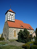
| Friedrichswalde, Michaeliskirche
|
53°01′43″N 13°42′25″E / 53.028679°N 13.706883°E / 53.028679; 13.706883
|
St. Michaeliskirche (Friedrichswalde) (1 C, 4 F)
|

|
| Glambeck, Dorfkirche
|
53°01′19″N 13°49′32″E / 53.022063°N 13.825587°E / 53.022063; 13.825587
|
Dorfkirche (Glambeck im Barnim) (1 C, 5 F)
|

|
| Golzow, Dorfkirche
|
52°54′41″N 13°48′33″E / 52.911510°N 13.809100°E / 52.911510; 13.809100
|
Dorfkirche (Golzow im Barnim) (empty)
|

|
| Groß Schönebeck, Immanuelkirche
|
52°54′22″N 13°31′50″E / 52.906177°N 13.530596°E / 52.906177; 13.530596
|
Immanuelkirche (Groß Schönebeck) (1 C, 1 P, 8 F)
|

|
| Groß Ziethen, Dorfkirche
|
52°57′32″N 13°53′41″E / 52.958959°N 13.894720°E / 52.958959; 13.894720
|
Dorfkirche Groß Ziethen (Barnim) (empty)
|

|
| Grüntal, Dorfkirche
|
52°44′35″N 13°43′19″E / 52.742948°N 13.722048°E / 52.742948; 13.722048
|
Dorfkirche (Grüntal in Brandenburg) (empty)
|
|
| Hirschfelde, Dorfkirche
|
52°38′14″N 13°47′55″E / 52.637316°N 13.798568°E / 52.637316; 13.798568
|
Dorfkirche (Hirschfelde im Barnim) (empty)
|

|
| Hohenfinow, Dorfkirche
|
52°48′38″N 13°55′29″E / 52.810584°N 13.924745°E / 52.810584; 13.924745
|
Dorfkirche (Hohenfinow) (empty)
|

|
| Joachimsthal, Kreuzkirche
|
52°58′40″N 13°44′33″E / 52.977778°N 13.7425°E / 52.977778; 13.7425
|
Kreuzkirche (Joachimsthal) (1 C, 14 F)
|

|
| Klandorf, Dorfkirche
|
52°52′22″N 13°33′54″E / 52.872752°N 13.565118°E / 52.872752; 13.565118
|
Dorfkirche (Klandorf) (empty)
|

|
| Klein Ziethen, Dorfkirche
|
52°57′37″N 13°55′48″E / 52.960140°N 13.929914°E / 52.960140; 13.929914
|
Dorfkirche Klein Ziethen (Barnim) (empty)
|

|
| Klobbicke, Dorfkirche
|
52°45′35″N 13°48′05″E / 52.759642°N 13.801348°E / 52.759642; 13.801348
|
Dorfkirche (Klobbicke) (empty)
|
|
| Klosterfelde, Dorfkirche
|
52°47′30″N 13°28′50″E / 52.791629°N 13.480549°E / 52.791629; 13.480549
|
Dorfkirche (Klosterfelde) (empty)
|
|
| Krummensee, Dorfkirche
|
52°35′47″N 13°41′34″E / 52.596328°N 13.692845°E / 52.596328; 13.692845
|
Dorfkirche Krummensee (1 C, 19 F)
|
|
| Ladeburg, Dorfkirche
|
52°42′07″N 13°35′15″E / 52.702059°N 13.587491°E / 52.702059; 13.587491
|
Dorfkirche (Ladeburg in Brandenburg) (7 F)
|

|
| Lanke, Dorfkirche
|
52°45′41″N 13°33′54″E / 52.761468°N 13.564880°E / 52.761468; 13.564880
|
Dorfkirche Lanke (1 C, 6 F)
|

|
| Lichterfelde, Dorfkirche
|
52°52′04″N 13°44′59″E / 52.867907°N 13.749699°E / 52.867907; 13.749699
|
Dorfkirche Lichterfelde (Barnim) (1 P, 11 F)
|

|
| Liepe, Dorfkirche
|
52°51′42″N 13°58′07″E / 52.861677°N 13.968513°E / 52.861677; 13.968513
|
Dorfkirche (Liepe im Barnim) (empty)
|

|
| Lindenberg, Dorfkirche
|
52°36′01″N 13°31′18″E / 52.600346°N 13.521772°E / 52.600346; 13.521772
|
Lindenberg (Barnim) church (empty)
|

|
| Lobetal, Waldkirche
|
52°43′40″N 13°35′46″E / 52.727752°N 13.596075°E / 52.727752; 13.596075
|
Gemeindekirche Lobetal (2 F)
|

|
| Löhme, Dorfkirche
|
52°37′43″N 13°40′23″E / 52.628721°N 13.673105°E / 52.628721; 13.673105
|
Dorfkirche Löhme (1 C, 1 P, 14 F)
|

|
| Lüdersdorf, Dorfkirche
|
52°55′54″N 14°04′23″E / 52.931558°N 14.073121°E / 52.931558; 14.073121
|
Dorfkirche (Lüdersdorf im Barnim) (1 F)
|

|
| Lunow, Dorfkirche
|
52°55′43″N 14°07′12″E / 52.928700°N 14.119911°E / 52.928700; 14.119911
|
Dorfkirche (Lunow) (2 F)
|

|
| Marienwerder, Dorfkirche
|
52°50′31″N 13°35′58″E / 52.841956°N 13.599356°E / 52.841956; 13.599356
|
Dorfkirche (Marienwerder im Barnim) (3 F)
|

|
| Mehrow, Dorfkirche
|
52°34′14″N 13°36′58″E / 52.570611°N 13.616002°E / 52.570611; 13.616002
|
Mehrow church (empty)
|

|
| Melchow, Dorfkirche
|
52°46′28″N 13°42′14″E / 52.774495°N 13.703905°E / 52.774495; 13.703905
|
Dorfkirche Melchow (6 F)
|

|
| Neuendorf, Wehrkirche
|
52°53′30″N 14°03′09″E / 52.891674°N 14.052389°E / 52.891674; 14.052389
|
Dorfkirche Neuendorf (8 F)
|

|
| Niederfinow, Dorfkirche
|
52°50′04″N 13°55′45″E / 52.834383°N 13.929247°E / 52.834383; 13.929247
|
Dorfkirche (Niederfinow) (15 F)
|

|
| Oderberg, Nikolaikirche
|
52°51′59″N 14°02′37″E / 52.866461°N 14.043716°E / 52.866461; 14.043716
|
Nikolaikirche, Oderberg (1 C, 13 F)
|

|
| Parlow, Dorfkirche
|
53°01′28″N 13°45′43″E / 53.024481°N 13.761997°E / 53.024481; 13.761997
|
Dorfkirche Parlow (1 F)
|

|
| Parstein, Dorfkirche
|
52°55′59″N 14°02′10″E / 52.933013°N 14.036079°E / 52.933013; 14.036079
|
Dorfkirche (Parstein) (empty)
|

|
| Prenden, Dorfkirche
|
52°47′25″N 13°33′00″E / 52.790394°N 13.549997°E / 52.790394; 13.549997
|
Prenden church (1 C, 11 F)
|

|
| Rüdnitz, Dorfkirche
|
52°43′16″N 13°37′26″E / 52.721080°N 13.623919°E / 52.721080; 13.623919
|
Dorfkirche (Rüdnitz) (4 F)
|

|
| Ruhlsdorf, Dorfkirche
|
52°49′34″N 13°33′39″E / 52.825982°N 13.560918°E / 52.825982; 13.560918
|
Dorfkirche Ruhlsdorf (1 P, 20 F)
|

|
| Schöpfurth, Dorfkirche
|
52°50′42″N 13°40′59″E / 52.845032°N 13.683098°E / 52.845032; 13.683098
|
Dorfkirche Schöpfurth (1 P, 18 F)
|
|
| Schönerlinde, Dorfkirche
|
52°39′13″N 13°26′50″E / 52.653639°N 13.447167°E / 52.653639; 13.447167
|
Dorfkirche (Schönerlinde) (14 F)
|

|
| Schönfeld, Dorfkirche
|
52°40′51″N 13°44′24″E / 52.680961°N 13.740008°E / 52.680961; 13.740008
|
Dorfkirche (Schönfeld im Barnim) (17 F)
|

|
| Schönow, Dorfkirche
|
52°40′44″N 13°32′03″E / 52.678865°N 13.534076°E / 52.678865; 13.534076
|
Dorfkirche Schönow (3 F)
|

|
| Schönwalde, Dorfkirche
|
52°40′45″N 13°26′25″E / 52.679073°N 13.440145°E / 52.679073; 13.440145
|
Dorfkirche (Schönwalde im Barnim) (2 F)
|
|
| Schwanebeck, Dorfkirche
|
52°37′30″N 13°32′36″E / 52.625026°N 13.543404°E / 52.625026; 13.543404
|
Dorfkirche (Schwanebeck im Barnim) (1 C, 11 F)
|

|
| Seefeld, Dorfkirche
|
52°37′21″N 13°40′38″E / 52.622574°N 13.677194°E / 52.622574; 13.677194
|
Dorfkirche (Seefeld) (empty)
|

|
| Senftenhütte, Dorfkirche
|
52°55′56″N 13°51′31″E / 52.932308°N 13.858559°E / 52.932308; 13.858559
|
Dorfkirche (Senftenhütte) (6 F)
|

|
| Serwest, Dorfkirche
|
52°56′08″N 13°55′45″E / 52.935582°N 13.929174°E / 52.935582; 13.929174
|
Dorfkirche (Serwest) (empty)
|

|
| Sophienstädt, Dorfkirche
|
52°48′46″N 13°34′54″E / 52.812671°N 13.581544°E / 52.812671; 13.581544
|
Dorfkirche Sophienstädt (6 F)
|

|
| Steinfurt, Dorfkirche
|
52°50′55″N 13°41′02″E / 52.848642°N 13.683771°E / 52.848642; 13.683771
|
Kirche Finowfurt (empty)
|

|
| Stolzenhagen (Wandlitz), Dorfkirche
|
52°46′39″N 13°26′19″E / 52.777531°N 13.438541°E / 52.777531; 13.438541
|
Church in Stolzenhagen (empty)
|

|
| Stolzenhagen (Oder), Dorfkirche
|
52°57′04″N 14°06′07″E / 52.951130°N 14.102003°E / 52.951130; 14.102003
|
Dorfkirche (Stolzenhagen auf der Odergeest) (1 F)
|

|
| Sydow, Dorfkirche
|
52°44′22″N 13°42′43″E / 52.739567°N 13.711901°E / 52.739567; 13.711901
|
Dorfkirche Sydow (4 F)
|

|
| Tempelfelde, Dorfkirche
|
52°42′34″N 13°43′08″E / 52.709361°N 13.718872°E / 52.709361; 13.718872
|
Dorfkirche (Tempelfelde) (6 F)
|

|
| Tornow, Dorfkirche
|
52°49′04″N 13°53′30″E / 52.817822°N 13.891658°E / 52.817822; 13.891658
|
Dorfkirche Tornow (Eberswalde) (1 C, 1 P, 24 F)
|
|
| Trampe, Dorfkirche
|
52°46′40″N 13°50′05″E / 52.777870°N 13.834614°E / 52.777870; 13.834614
|
Dorfkirche Trampe (Barnim) (6 F)
|

|
| Tuchen, "Hochzeitskirche"
|
52°45′16″N 13°47′16″E / 52.754557°N 13.787820°E / 52.754557; 13.787820
|
Dorfkirche (Tuchen) (1 C, 4 F)
|

|
| Wandlitz, Dorfkirche
|
52°45′13″N 13°27′07″E / 52.753552°N 13.451891°E / 52.753552; 13.451891
|
Dorfkirche (Wandlitz) (empty)
|
|
| Wandlitz, kath. Kirche St. Konrad
|
52°45′33″N 13°28′21″E / 52.759125°N 13.472426°E / 52.759125; 13.472426
|
Sankt Konrad (Wandlitz) (empty)
|
|
| Weesow, Dorfkirche
|
52°39′01″N 13°43′21″E / 52.650302°N 13.722413°E / 52.650302; 13.722413
|
Dorfkirche (Weesow) (empty)
|
|
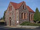
| Werbellin, Autobahnkirche
|
52°53′26″N 13°42′13″E / 52.890639°N 13.703694°E / 52.890639; 13.703694
|
Autobahnkirche Werbellin (5 F)
|

|
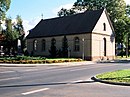
| Werneuchen, Stadtpfarrkirche St. Michael
|
52°37′55″N 13°43′55″E / 52.631916°N 13.731806°E / 52.631916; 13.731806
|
Stadtkirche St. Michael (Werneuchen) (2 F)
|

|
| Werneuchen, kath. St.Joseph-Kirche
|
52°38′07″N 13°44′14″E / 52.635239°N 13.737139°E / 52.635239; 13.737139
|
Werneuchen - St. Joseph-Kirche (empty)
|

|
| Willmersdorf, Dorfkirche
|
52°39′49″N 13°41′04″E / 52.663544°N 13.684442°E / 52.663544; 13.684442
|
Dorfkirche Willmersdorf (Barnim) (7 F)
|

|
| Zepernick, ev. Pfarrkirche St. Annen
|
52°39′19″N 13°32′34″E / 52.655151°N 13.542752°E / 52.655151; 13.542752
|
St. Annenkirche (Zepernick bei Bernau) (2 F)
|

|
| Zepernick, kath. Kirche „Maria, Hilfe der Christen“
|
52°38′31″N 13°33′24″E / 52.641928°N 13.556693°E / 52.641928; 13.556693
|
|
|
| Zepernick, Friedenskapelle
|
52°39′03″N 13°32′11″E / 52.650957°N 13.536517°E / 52.650957; 13.536517
|
|
|
| Zepernick, Neuapostolische Kirche
|
52°39′38″N 13°31′41″E / 52.660482°N 13.528176°E / 52.660482; 13.528176
|
|
|
| Zerpenschleuse, Dorfkirche
|
52°51′23″N 13°30′33″E / 52.856314°N 13.509261°E / 52.856314; 13.509261
|
Dorfkirche Zerpenschleuse (4 F)
|

|


_09.JPG)


_church_2015_S.jpg)


.JPG)
.JPG)
_2012-11-13_ama_fec.jpg)


_a.JPG)


.JPG)
_2015_SE.jpg)


.JPG)


