Category:Dorfkirche Zerpenschleuse
Jump to navigation
Jump to search
| Object location | | View all coordinates using: OpenStreetMap |
|---|
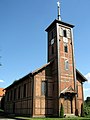
church building in Barnim district, Brandenburg state, Germany  | |||||
| Upload media | |||||
| Instance of | |||||
|---|---|---|---|---|---|
| Location | Zerpenschleuse, Wandlitz, Barnim District, Brandenburg, Germany | ||||
| Street address |
| ||||
| Architect | |||||
| Heritage designation | |||||
| Inception |
| ||||
| Width |
| ||||
| Length |
| ||||
| Area |
| ||||
 | |||||
This is the category of the Brandenburger Baudenkmal (cultural heritage monument) with the ID 09175424 (Wikidata)
|
English: Pictures of the church in Zerpenschleuse, Wandlitz municipality, Barnim district, Brandenburg state, Germany.
Deutsch: Ansichten der Kirche in Zerpenschleuse, Gemeinde Wandlitz , Landkreis Barnim , Land Brandenburg , Deutschland.
Français : Photos de l'église à Zerpenschleuse, commune de Wandlitz, , arrondissement de Barnim , état federé de Brandebourg , Allemagne.
Español: Vistas de la iglesia en Zerpenschleuse, municipio de Wandlitz, distrito de Barnim , estado federado de Brandeburgo , Alemania.
Address: Liebenwalder Straße 56, 16348 Wandlitz - Zerpenschleuse
Pages in category "Dorfkirche Zerpenschleuse"
This category contains only the following page.
Media in category "Dorfkirche Zerpenschleuse"
The following 10 files are in this category, out of 10 total.
-
 Dorfkirche Zerpenschleuse 2022 Fenster.jpg 3,648 × 4,864; 5.17 MB
-
 Dorfkirche Zerpenschleuse 2022 NE.jpg 3,648 × 3,648; 2.44 MB
-
 Dorfkirche Zerpenschleuse 2022 NW.jpg 3,648 × 4,864; 2.44 MB
-
 Dorfkirche Zerpenschleuse 2022 Panorama S.jpg 4,276 × 2,907; 2.03 MB
-
 Dorfkirche Zerpenschleuse 2022 Portal N.jpg 3,648 × 4,864; 5.01 MB
-
 Dorfkirche Zerpenschleuse 2022 Portal W.jpg 3,575 × 4,815; 3.53 MB
-
 Zerpenschleuse Kirche 01.jpg 3,449 × 2,587; 1.7 MB
-
 Zerpenschleuse Kirche 02.jpg 2,601 × 3,464; 1.75 MB
-
 Zerpenschleuse Kirche 03.jpg 2,547 × 3,404; 1.57 MB
-
 Zerpenschleuse Kirche 04.jpg 3,459 × 2,594; 1.79 MB


