User:Dcrjsr/gallery of Eastern Sierra images
Jump to navigation
Jump to search

- Eastern Sierra images by User:Dcrjsr
-
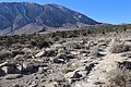
 SW edge of Alabama Hills, Owens Valley
 -
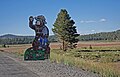
 Big Pine's Big Tree
 -
 Bristlecone pine, White Mountains
 -
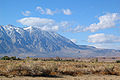
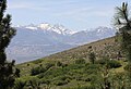
 Deep Springs NV, from White Mountains
 -
 Coyote flats near sunset from Lower Rock Creek
 -
 Row of golden fall aspen, Aspendell
 -
 Pond ringed with golden fall aspen, Aspendell
 -
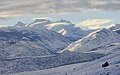
 Mt Humphries from Owens Valley
 -
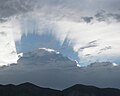 Crown-ray cloud shadow, Owens Valley
 -
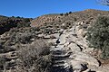
 Old wagon road, looking uphill from Owens Valley
 -
 Old wagon road, looking downhill to Owens Valley
 -
 Old wagon road topping rise, below Swall Mdws
 -
 Worn tracks on wagon road, uphill by canyon
 -
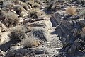 Closeup: tracks worn in rock, on old wagon road
 -
 Level bit on old wagon road up Sherwin Grade
 -
 Wheeler Crest from Owens Valley
 -
 Swall meadows, under Wheeler Crest
 -
 Round Valley deer herd in Swall Meadows
 -
 Old apple tree Swall orchard
 -
 Swall Meadows street map (Open Street Map)
 -
 Owens Valley from Swall corner, winter
 -
 Owens River Gorge, valley, mtns
 -
 Mt Tom from Swall Meadows
 -
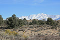 White Mtns, past ridge with pinyons
 -
 Late snow on the White Mountains
 -
 White Mtn canyons up from Owens Valley
 -
 White Mtns (Blanco peak) snow, from west
 -
 Wheeler Crest rocks ,from the east
 -
 Sunrise light, Wheeler Crest rocks & snow
 -
 Wheeler Crest pink snow sunrise
 -
 Lit mist on Wheeler Crest snow slope
 -
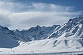
 Swall Bishop Pass view, snow
 -
 Cloudripper ripping cloud, snowy am
 -
 Closeup of clouds over Cloudripper
 -
 Cloudripper & Bishop Pass, from Swall Mdws
 -
 Desert paintbrush on hillside, in May
 -
 Pinyon pine (Pinus monophylla) with snow
 -
 Lower Rock Creek rock in meltout flow
 -
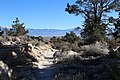
 Sand Canyon Road, bench above Upper Rock Creek
 -
 Old wagon road between Swall & Tom's Place
 -
 Sheep herd, meadow in Little Round Valley
 -
 Crowley Lake pm light, with cows
 -
 Boundary Pk past Crowley Lake, from McGee Rd
 -
 White Mountains sunset, from Pine Creek Trail
 -
 Lake Sabrina sunset
 -
 McGee Creek valley in winter, from US395
 -
 Twin Lakes, falls, & Mammoth Crest
 -
 Mammoth Mountain rainbow
 -
 Minarets silhouette, evening
 -
 Smokey Bear Flat, N of Mammoth
 -
 Mono Pass (N) from east side, winter
 -
 Tioga Lake from the south end
 -
 Beaver-cut aspen, Lundy Canyon
 -
 Lundy canyon: cliffs, falls, beaver dam
 -
 Aspen-lined path, Lundy Canyon
 -
 S Sierra over Mono Lake winter clouds
 -
 Mono Lake down thru clouds from Conway Summit
 -
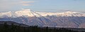
 Snowy peaks NW from Conway Summit vista
 -
 Dunderberg Peak from Big Meadow, Bridgeport
 -
 Sawtooth Range past Twin Lakes, Bridgeport winter
 -
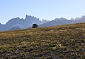
 Sawtooth Range from Big Meadow, summer
 -
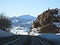 Devil's Gate Pass in winter, N of Bridgeport
 -
 W Walker River between Emigrant & Leavitt Mdws


