Maps of Russian federal subjects before 2005
Jump to navigation
Jump to search
Maps of Russian federal subjects before 1 December 2005, when the new Perm krai came into use.
- Maps are also available as part of the
 Wikimedia Atlas of the World project in the Atlas of Russia.
Main category: Locator maps of federal subjects in Russia, old
Blank
[edit]
Autonomous districts
[edit]-
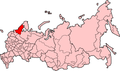
 Khantia-Mansia
 -
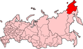 Chukotka


Republics
[edit]-
 Adygea
 -
Altay
-
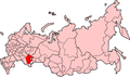 Bashkortostan
 -
 Buryatia
 -
 Chechnya
 -
 Chuvashia
 -
 Dagestan
 -
 Ingushetia Republic
 -
 Kabardino-Balkaria
 -
 Karelia Republic
 -
 Khakassia Republic
 -
 Komi
Komi -
 Mari El
 -
 Mordovia
 -
 North Ossetia-Alania Republic
 -
 Sakha
Sakha -
 Tatarstan
 -
 Tuva
Tuva -
 Udmurtia


Oblasts
[edit]See Области России до 2005 года
Krais
[edit]-
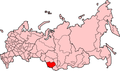 Altai Krai
 -
 Khabarovsk Krai
 -
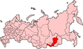
 Krasnodar Krai
 -
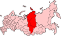 Krasnoyarsky Krai
 -
 Primorsky Krai
 -
 Stavropol Krai


