Maps of Russian federal subjects 2005
Jump to navigation
Jump to search
Maps of Russian federal subjects as of 1 December 2005, when the new Perm krai came into use.
- Maps are also available as part of the
 Wikimedia Atlas of the World project in the Atlas of Russia.
Main category: Locator maps of federal subjects in Russia 2005
Empty
[edit]-
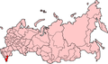
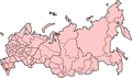
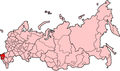
 Empty map of Russian federal subjects

Autonomous districts
[edit]Main category: Locator maps of autonomous districts in Russia 2005
-
 Aga Buryatia
 -
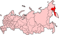
 Chukotka
 -
 Evenkia
 -
 Khantia-Mansia
 -
 Koryakia
 -
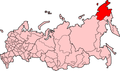
 Nenetsia
 -
 Taymyria
 -
 Ust-Orda Buryatia
 -
 Yamalia


Republics
[edit]-
 Adygea
 -
 Altay
Altay -
 Bashkortostan
 -
 Buryatia
 -
 Chechnya
 -
 Chuvashia
 -
 Dagestan
 -
 Ingushetia Republic
 -
 Kabardino-Balkaria
 -
 Kalmykia
 -
 Karachay-Cherkessia
 -
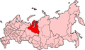
 Karelia Republic
 -
 Khakassia Republic
 -
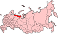
 Komi
Komi -
 Mari El
 -
 Mordovia
 -
 North Ossetia-Alania Republic
 -
 North Ossetia-Alania Republic
 -
 Sakha
Sakha -
 Tatarstan
 -
 Tuva
Tuva -
 Udmurtia


Oblasts
[edit]Krais
[edit]-
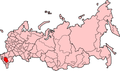
 Altai Krai
 -
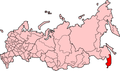
 Khabarovsk Krai
 -
 Krasnodar Krai
 -
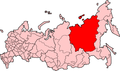
 Krasnoyarsky Krai
 -
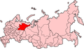
 Perm Krai
 -
 Primorsky Krai
 -
 Stavropol Krai


