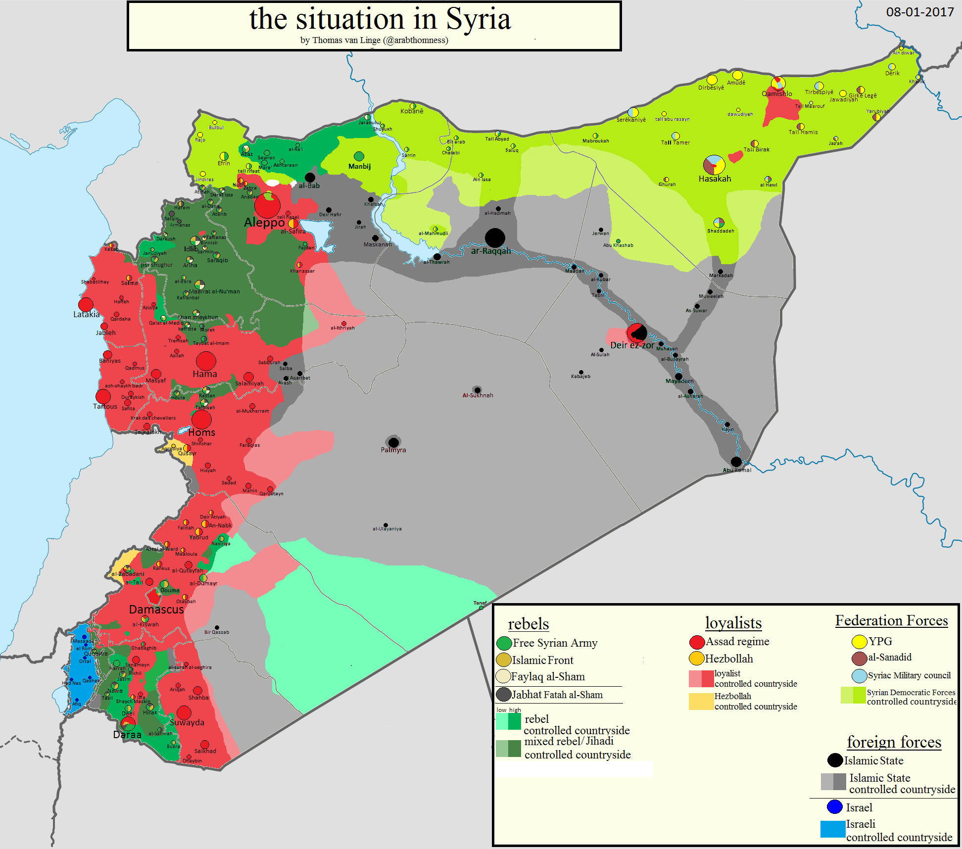
File talk:Syrian, Iraqi, and Lebanese insurgencies.png/Archive 1

Major Highways
Does anyone have (and can include in the map) info about major highways? This would help a lot in understanding the strategic situation (e.g. Sinjar is, I believe, along the strategic highway linking Raqqa, Syria to Mosul, Iraq). Gazilion (talk) 11:31, 28 December 2015 (UTC)
- That could help viewers understand the supply lines and reasons behind tactical advances, but such a change would make the maps affected a lot harder to update, not to mention much more time-consuming. It would be best to leave the roads on the modules on Wikipedia, after all, there are a lot of links to them, so people can view the roadways there instead. BlueHypercane761 (talk) 02:17, 11 January 2016 (UTC)
Highway to Aleppo (4.11.2015)
Syrian gov claims to reopen Aleppo-Khanasser-Ithriya-al-Salmiyeh road, source: http://www.presstv.ir/Detail/2015/11/04/436261/syria-militant-aleppo-road-army- 178.219.136.247 21:33, 4 November 2015 (UTC)
)
Light base color for desert/unpopulated areas?
Maybe an adaptation of the color spectrum with a very light shade of the base color for desert/sparsely populated areas could help understand the control of areas better. The inclusion of towns and villages already helps a lot. As an example the map at http://isis.liveuamap.com/ only shows area under control, meaning areas with population. This would also allow us to understand big gains in area as it often only shows "control" the deserted areas, although only a town is captured an the whole deserted back country is now under control. FireSoulHC (talk) 07:07, 12 August 2015 (UTC)
- When we represent recognised countries' borders we don't show desert/sparsely populated areas in a different colour (unless it's specifically a demographics map), why should we represent Daesh's territory in a different way? Gazilion (talk) 11:27, 28 December 2015 (UTC)
- But this is not a country map - it is a map of the conflict situation! If no-one has control over disputed territory, then colouring it for any faction is misleading. The https://isis.liveuamap.com/ page seems to have more detail, but it looks like this file follows the http://syriancivilwarmap.com/ map more closely. Is there a reason for this? Maybe there could be white areas but smaller than the http://syriancivilwarmap.com/ page just to show where there is no shared border of control/ conflict front. 88.107.178.190 15:30, 22 October 2016 (UTC)
Updates as of Aug 12th 2015
Since I do not want to interfere with the users that know how to update the map here are some recent developments.
ISIS
- capture of Al-Qaryatayn https://en.wikipedia.org/wiki/Al-Qaryatayn (5 August 2015)
YPG and FSA
- capture of Sarrin https://en.wikipedia.org/wiki/Sarrin: Battle_of_Sarrin (26 July 2015) https://en.wikipedia.org/wiki/Battle_of_Sarrin_(June%E2%80%93July_2015)
- capture of Sarrin surroundings (up to Tishrin_Dam? https://en.wikipedia.org/wiki/Tishrin_Dam): Battle_of_Sarrin https://en.wikipedia.org/wiki/Battle_of_Sarrin_(June%E2%80%93July_2015) (up to 4 August 2015)
- capture of Al-Hasakah https://en.wikipedia.org/wiki/Al-Hasakah: Battle_of_Al-Hasakah https://en.wikipedia.org/wiki/Battle_of_Al-Hasakah_(June–August_2015) (up to 1 August 2015)
- capture of surrounding areas of Al-Hasakah: Battle_of_Al-Hasakah Aftermath https://en.wikipedia.org/wiki/Battle_of_Al-Hasakah_(June–August_2015)#Aftermath
Iraq - Anbar province
- heavy clashes and small progress by both sides http://isis.liveuamap.com/
general - Combined Joint Task Force – Operation Inherent Resolve
- no fly-zone between Aleppo and Euphrates river? http://isis.liveuamap.com/
FireSoulHC (talk) 07:07, 12 August 2015 (UTC)
Strange Edit
Hi all, hope I wasn't out of line reverting the last change, which apparently took the rumour that Turkey was to create a buffer zone between Rojava and Afrin (which is now being denied: http://news.yahoo.com/turkish-pm-denies-plans-imminent-intervention-syria-100807741.html) and took it as current reality on the ground, also for some reason depicting this area as Kurdish-controlled, which is simply incorrect.
- The buffer zone is in planning http://www.bbc.com/news/world-europe-33681215 FireSoulHC (talk) 07:07, 12 August 2015 (UTC)
Contents of Map
Please add names of big and/or important places especially if there is a big red or black dot — even on the thumb version. Thanks! Asia-Checking (talk) 12:33, 23 June 2015 (UTC)
Style of Map
Please, change colors in Lebanon - they are ugly and map looks bad because of that.
- There are a limited number of colors that can be used for Lebanon. However, I have changed the color 2 or 3 times now, and hopefully, it looks much better. BlueHypercane761 (talk) 21:48, 25 June 2015 (UTC)
Scale
Please insert a 100 miles bar or 100 km. -- Korkwand (talk) 19:38, 5 July 2015 (UTC)
Vector version
This map is really important, widely used and seems to be updated frequently. Would it be possible to produce a vector version (svg instead of png)? That should give better image quality, scalability, and smaller file size. --DufterKunde (talk) 09:00, 8 July 2015 (UTC)
Colors
Are someone able to re-introduce the colors for Lebanon and Hezbollah as of July 25? I would do it, but I don't know how. --Mikrobølgeovn (talk) 18:34, 28 July 2015 (UTC)
Colors of towns are standardized (ISIL: black, ISF: red). While editing the map, please make sure that you do not add any new colors to the map. I reverted the recently made changes but only because of the color issue. (talk) 20:36, 17. October 2016 (CEST) — Preceding unsigned comment was added by 2003:65:E917:E743:D46E:73E7:655A:AB82 (talk) 18:37, 17 October 2016 (UTC)
Qaryatain
ISIS have conquered Qaryatain and so the map needs an update.
Outdated maps
I see the Aleppo and Lebanon maps were outdated (the Lebanon map had old colors, some territorial changes of ISIL and Nusra, and the Aleppo map have Military Research Center contested and small territorial changes). Please update these maps, because they were outdated. --SMB99thx (talk) 03:10, 20 August 2015 (UTC)
- Oh, the Damascus map were outdated too (truce area in northwest of the map and three villages near that area were in FSA control now) and the truce icons need an update now (purple dot only rather than purple border with red and green halves). --SMB99thx (talk) 03:34, 20 August 2015 (UTC)
- I've updated the entire map based on the module. Banak (talk) 20:36, 20 August 2015 (UTC)
Key Question: What are the red and black dots?
What do the red and black dots indicate? I assume they are towns, but what is the significance of the red? Thanks --Yoderj (talk) 04:12, 23 August 2015 (UTC)
- I see it now -- the color of the dots is simply who controls the city, just like the background color. Thanks --Yoderj (talk) 04:17, 23 August 2015 (UTC)
Lebanon Map
Can I suggest using a salmon red for the Lebanese government, #e85656, and an orange for Hezbollah, #e57100?
Disputed territory color
Very informative map, thanks to all contributors. I would like to suggest one edit – changing the color of the last category (disputed territory), because on the map it risks being confused with two others:
With the labels they're clearly distinct, but when seen on the map without text, an area of Kurdish control could be mistaken for a brown disputed area – it threw me a little at first. Maybe disputed territory could be, for instance, a dark gray or a dark green, or something else?
Best wishes, Demokra (talk) 01:04, 11 September 2015 (UTC)
Most recent revision
I feel we should revert the most recent change to the map; while it's true there's minimal or no IS activity in Lebanon, that's no reason to blank it out on the map - after all, the map is meant to show the territories of all of the insurgent groups in the area (hence the "And Lebanese Insurgencies" in the title), as opposed to just the ones in Syria and Iraq.
Any thoughts?
206.223.166.51 15:54, 18 September 2015 (UTC)
Revisions by Banak
Banak, why don't you just provide sources here? Your revisions have been persistently contested. Rob984 (talk) 15:21, 3 October 2015 (UTC)
- Rob984I wasn't intending on being active yesterday, which is the only day I've noticed any problems Normally someone asks sources, I say see the modules and there's no problem. If you look at my (newly updated) userpage and several comments I've made, it's on the Iraqi, Syrian and Lebanese maps. As I say on my userpage I don't expect to be contacted on commons and ask that important questions are mentioned on my English wikipedia page.
- This entire situation is ridiculous, especially if you consider the version of the map that is being reverted to has no stated source, and the number of times I have said to bring problem's up at the module, and the sudden interest in sources.
- My revert once again said to see those modules history and talkpage, as you will see if you look at the upload log. I have pointed this out many times on many pages.
- My action yesterday was this: uploas a new map, reverting once referring to where the sources are in response to a revert saying that there were no sources, and posting on the guy who repeatedly reverted's userpage to get them to stop reverting themself to no effect. I did not intend to have a long discussion yesterday, and was happy to leave the map unupdated for a day. Alas that didn't happen. Banak (talk) 17:21, 3 October 2015 (UTC)
How is this created?
How is this map created please? What software is used, and where is the data from? I think this should be documented so that anyone can edit it. After all, Wikipedia is supposed to be editable by anyone. --Rebroad (talk) 14:42, 8 October 2015 (UTC)
Rebroad, though this isn't Wikipedia, and it's actually Wikimedia Commons. Most files here aren't actually meant to be edited, updated and don't have to be from a Neutral Point of View etc. This map is incredibly unusual as it is actually based off Wikipedia and frequently undated, in particular en:Template:Syrian,_Iraqi,_and_Lebanese_insurgencies_detailed_map. This runs code from combining en:Module:Syrian_Civil_War_detailed_map, en:Module:Iraqi_insurgency_detailed_map and en:Module:Lebanese Insurgency detailed map using Lua. The talk pages of those modules, and the history of the modules discuss details. Banak (talk) 17:13, 8 October 2015 (UTC)
Thanks! --Rebroad (talk) 15:23, 13 October 2015 (UTC)
Sinjar
The Peshmerga has captured the city of sinjar, this map should be updated to reflect it [1] — Preceding unsigned comment was added by 174.26.180.206 (talk) 14:51, 14 November 2015 (UTC)
Turkmens and Ahrar es-Sham
Ahrar on this map , and the Turkmen should be shown in the. Mehk63 (talk) 17:56, 4 March 2016 (UTC)
Palmyra
Didn't the Syrian army just take Palmyra? Maybe the map hasn't been updated yet. Regards, --Leoboudv (talk) 09:12, 27 March 2016 (UTC)
- In this case I think this site keeps the best detailed and updated info. Re the taking of key positions around Palmyra (incl. airport, west, south, north and probably east-bound road) plus encirclement of central Palmyra. I've found no video report of SAA in central Palmyra, but maybe that's on its way.
- BTW, the allied advance in eastern parts of Nineveh province in Iraq isn't well reported. Wonder what's happening.--Paracel63 (talk) 17:32, 27 March 2016 (UTC)
- OK, Thank you for the information, --Leoboudv (talk) 18:39, 27 March 2016 (UTC)
Image Note Reversion
Someone added a note to the image itself a couple of days ago with a long claim of purported ISIL military gains, but I don't see any sources, nor are the gains reflected on the map. Also, the content seems dubious - if ISIL really "Broke the Siege of Fallujah" or took the DeZ airport, you'd think that would have been all over the news. Finally, I don't think it's usual practice for notes to be placed on the map (as opposed to the map itself being updated).
After deliberation, I've reverted the edit. For the sake of full disclosure, I'm leaving this note here in case the user who put it in, or any other user, wants to debate the matter. --206.223.166.51 16:26, 5 April 2016 (UTC)
Outdated Map
The frequency of updates to the map seems to have come to a stop. I don't know if this means that BlueHypercane761 is taking a break or decided to stop in general. Regardless an updated map is needed. I found that http://isis.liveuamap.com/ is a great source for finding current territorial changes. Robotx2300 (talk) 19:17, 17 April 2016 (UTC)
- Yes i totally agree with you! I would like to do that but i don't have enough information for updates! I hope BlueHypercane761 or another user will do an update soon! --77.116.94.124 22:19, 19 April 2016 (UTC)
- Great! BlueHypercane761 is back on Wikipedia! Thank you BlueHypercane761! :)
- --178.112.219.218 17:30, 20 April 2016 (UTC)
- Update please! :) --178.114.87.227 11:44, 8 May 2016 (UTC)
- Please someone should update those f***** map! Otherwise clear it! It's a fucking crap to see always just the old map! — Preceding unsigned comment was added by 77.116.56.11 (talk) 00:17, 24 May 2016 (UTC)
- Update please! :) --178.114.87.227 11:44, 8 May 2016 (UTC)
- Does anyone know what tools and sources were being used for this? We shouldn't have to rely on one or two users to keep this updated. Aremisasling (talk) 12:46, 28 July 2016 (UTC)
- That's right, i would also like to know cause sometime i would like to chance the map cause of actual events and don't know exactly how to do! — Preceding unsigned comment was added by 94.185.82.138 (talk) 17:16, 30 July 2016 (UTC)
- We were using en:Template:Syrian, Iraqi, and Lebanese insurgencies detailed map with a 50% transparency layer of colouring in the foreground, but we have deviated from this a bit, and there was a bit of an argument over discrepancies between the image and the module, and where the burden of proof in relation to the differences lay. If we were still basing it on the template, I'd say just change (in accordance with the general wikipedia rules and discretionary sanctions) the relevant module. Use a reliable source and discuss on relevant talkpages etc. You can find links to them on my userpage. Banak (talk) 23:23, 6 August 2016 (UTC)
- Correction: some of the current colours used cannot be done this way. The blue and orange (for lebanon) must have been coloured in on same layer, or with 100% transparency. This would explain the greater difficulty reading place names elsewhere if this technique was used. Banak (talk) 23:43, 6 August 2016 (UTC)
- Thanks for the Information! --94.185.82.138 18:34, 10 August 2016 (UTC)
- Correction: some of the current colours used cannot be done this way. The blue and orange (for lebanon) must have been coloured in on same layer, or with 100% transparency. This would explain the greater difficulty reading place names elsewhere if this technique was used. Banak (talk) 23:43, 6 August 2016 (UTC)
- We were using en:Template:Syrian, Iraqi, and Lebanese insurgencies detailed map with a 50% transparency layer of colouring in the foreground, but we have deviated from this a bit, and there was a bit of an argument over discrepancies between the image and the module, and where the burden of proof in relation to the differences lay. If we were still basing it on the template, I'd say just change (in accordance with the general wikipedia rules and discretionary sanctions) the relevant module. Use a reliable source and discuss on relevant talkpages etc. You can find links to them on my userpage. Banak (talk) 23:23, 6 August 2016 (UTC)
- That's right, i would also like to know cause sometime i would like to chance the map cause of actual events and don't know exactly how to do! — Preceding unsigned comment was added by 94.185.82.138 (talk) 17:16, 30 July 2016 (UTC)
Size of Manbij symbol is too big
The population of Raqqah is 220,268 (2012) and Manbij is 74,575 (2009). So, why is the Mabij city symbol bigger? --MarsRover (talk) 00:23, 23 August 2016 (UTC)
Turkey
I have noticed that Turkish forces (attested in the news) have been added to the map. But no-one has updated the Key. Whilst the update is occurring I wonder if it might be useful to add the colours used for towns under control by each faction as well. 80.43.160.7 15:23, 31 August 2016 (UTC)
Somebody has killed the the turkish forces, that isn't really helpful! Please correct this mistake! --ErhardSiller (talk) 11:28, 4 September 2016 (UTC)
- They've put them under the rebels colours. Banak (talk) 16:45, 4 September 2016 (UTC)
- Yes I see, but i don't think, that is a good solution --ErhardSiller (talk) 16:05, 6 September 2016 (UTC)
- I'm thinking there should be two maps:
- * One with aligned groups as one (JAN + rebels + Turks / Kurds / ISIS / gov)
- * One with aligned groups separate (JAN, rebels, Turks, SDF, PKK, ISIS, various Shia and Sunni militas).
- Thoughts? Magog the Ogre (talk) (contribs) 03:12, 7 September 2016 (UTC)
- To my knowledge turkey is using it's tanks, planes and special forces to back rebel troops. On JaN, I used to hear it wasn't clear exactly what they control, but now I hear that the Army of Conquest (JaF) and other similar Islamists might be more meaningfully given a colour. There have been a few discusions on this on the english wikipedia's map module for syria, but the older ones are very much forgotten, largely due to older editors having left or been banned or blocked. A recentish discussion on colour. As for other shia and sunni militias, I don't know if breaking up pro-SAA groups will be easy, non-SDF SDF-allied groups don't control a massive amount of land (though they do actually have the very small amount of cyan in Al-hasakah which isn't easy to spot). I'm not aware of the extent of any other non-rebel militias.
- The other issue is map updating. At the moment, we have three fairly different maps that involve syria in heavy use that I know of. This one, Syria only which I'm probably soon going to be updating per the module because it's pretty out of date, and Syria and Iraq which is per the module. I don't know how likely to be updated a new map would be.
- So all in all, in my opinion it sounds a bit too complicated for too little benefit, but maybe someone else disagrees and will do this. Banak (talk) 09:01, 7 September 2016 (UTC)
- Yes I see, but i don't think, that is a good solution --ErhardSiller (talk) 16:05, 6 September 2016 (UTC)
If turkey is going to be coloured, maybe the border appearance at Qamishli should be sorted. I know it is because there is an inserted graphic there, but it currently looks as if there is no turkish-syrian border for that region (particularly now that the colour difference highlights it). 88.107.178.190 23:48, 26 October 2016 (UTC)
- But it's interesting that why Lebanese needs to be colored, it didn't affected this war a lot, even can say little, besides, Turkey will play a more and more important role in this war, which try to defend the independence of Kurdish. I think clean the color on Lebanese and color Turkey might be better. 23:48, 19 Dec. 2016 (UTC+8)
What are these grids?
On the map I'm seeing these four by four grids consisting of what look like cross/pluss signs all in the same color as the controlling faction where they are found. They appear in each of the following Syrian and Iraqi Governorates (amount and relative location in parenthesis): Narrawa (x1; South-Southeast of Al-Ba'aj), Saladin (x1; East-Northeast of Tikrit in IS-held territory), Rif Dimashq (x2; in the Douma district in FSA-held territory), Homs (x2; one in IS territory near Al-Suknah, one in FSA held territory due-West of the Al-Tanf/Al-Walid border crossing), Hama (x2; IS and Syrian government held territory in the vicinity of Al-Ithriyah), and As-Suwayda (x1; Salkad district). Additionally there are three in the Hezbollah and ISIS territory around Arsal, and a single row of these marks in FSA held territory just east of the Homs Governorate's border with the Rif Dimashq Governorate. What are these, and more importantly what are their significance? My apologies if the locations are a bit too concise, but I thought that might help. — Preceding unsigned comment was added by 216.69.46.25 (talk) 20:35, 31 October 2016 (UTC)
- They represent local support in sparse areas. Some locals groups support ISIL, some support other groups. It helps label the map without marking towns that don't actually exist. 80.43.163.18 15:41, 4 November 2016 (UTC)
Sources (and errors)
The only sources i've seen listed are the syriancivilwarmap and isisliveuamap. What do you guys (Dr Fist and Salem Leo particularly) think of: https://www.google.com/maps/d/viewer?mid=1OSttyvbGKqntDjF8Q0vfHCHUZo4&hl=en_US&ll=36.181948278921475%2C43.43390373413081&z=9
>It shows more factions, such as Israel Defence Forces in Golan Heights region, and local forces North and East of Mosul.
>It also seems rather up-to-date, using the Mosul situation as an indicator.
>Having a third source/opinions helps the map balance out any errors. 80.43.163.18 15:50, 4 November 2016 (UTC)
)
And as a result of inspecting the google map, it looks like the Damascus label on the wikipage map is labelling the wrong thing. The city map to the west os 'Damascus' is actually Damascus, right? so why is it labelling [possibly] Bir Qassab?? 80.43.163.18 15:56, 4 November 2016 (UTC)
)
Mosul
The western flanks looks quite different than on isis.liveuamap.com and syriancivilwarmap.com and https://twitter.com/brett_mcgurk/status/797102036563148800, there the Iraqi government and allied forces are much further away from Mosul and are heading in the direction of Tal Afar, while on the map here it looks like they were very close to the Mosul airport, I assume that is wrong. I can't edit the map and also wouldn't dare to fiddle with it, so I can only urge someone to review this issue please.--79.194.247.165 01:25, 12 November 2016 (UTC)
- by the way, this new Brett McGurk tweet also gives some more source material for the Hawija pocket, just in case the usual editors start an argument about it ;).--79.194.247.165 01:30, 12 November 2016 (UTC)
Citing isis.liveuamap.com for changes, and the lack of explanation for changes in general
isis.liveuamap.com is almost entirely based off recent posts on Twitter. A lot of changes in territory have been missed out and forgotten about, leaving many areas highly inaccurate. Citing this source is meaningless, since it is based almost entirely off posts on Twitter and thus cannot be considered a reliable source. It would be better to actually cite the Twitter posts (better still, news articles). Also please explain what changes you have made, then atleast other contributors can easily verify the change through a Google News search. Do not just state "Update per isis.liveuamap.com", Salem Leo (I know others have done so as well). Rob984 (talk) 18:32, 13 November 2016 (UTC)
isis.liveuamap.com in fact seems to be partly outdated and inaccurate. There are ISIL enclaves marked in several parts of Iraq that no other online map knows about, Also, the political situation in the Southeastern Syrian border region is outdated by 5 months now. I wouldn't recommend to use it as a primary reference anymore. A similar case is http://syriancivilwarmap.com/syrian-civil-war-live-map-1/. The map displays relatively reliable information about the ongoing offensives in the northern regions of Syria and Iraq, but the information about the political situation in the south is relatively useless. Syriancivilwarmap.com seems to be pretty reliable, although I wouldn't agree with the frontline near Al-Tanf border crossing, Syria (see the following discussion point). The "Tutomap" Twitter channel, additionally, provides relatively reliable information about detailed territorial changes in certain regions. --Dr. Fist (talk) 23:21, 26 November 2016 (CEST)
Syrian/Iraqi border situation
The southern part of the Syrian/Iraqi border area has been edited back and forth a thousand times recent times although there hadn't been any fighting for months in the past months. This is because several maps about the ongoing war are contradictory. syriancivilwarmap.com displays that ISIL's fighters control most of the border area up to the outskirts of Al Tanf/Al Walid border crossing in South Syria/West Iraq. According to liveuamap.com, the New Syrian Army controls the whole border area and resides near Al Bukamal in Eastern Syria. How come? Well, some editors don't seem to be familiar with the geographic situation of this area. Other than the fertile Aleppo province with its hundreds of neighboring villages, Northeast Homs and Southeast Deir-ez-Zor provinces consist of nothing than empty desert. There are no villages, no military posts and no industrial zones. Feel free to check that on satellite images on google maps. The desert area between Al Tanf border crossing and Al Bukamal is 250km/150miles long. The "New Syrian Army", stationed at Al Tanf border crossing, crossed this desert once during their Al-Bukamal offensive in late June 2016. The offensive was repelled by ISIL after two days. The New Syrian Army was pushed back to Al Tanf. This had been the last military confrontation in this area and that explains why the maps display different frontlines. There haven't been any news from this area because the huge desert is a territory, which isn't in fact controlled by either one of the sides. Each conflict party's fighters would be heavily dependent on constant supply of food and water across the desert if they wanted to reside near the posts held by the opponent. If you have a look at the maps of the conflict in Syria on agathocledesyracuse.com, you can see that most of the border regions are not marked as held by any of the conflict parties. The situation on the Iraqi side is similar. There are cities, such as Akashat and Rutbah, which are held by the ISF and Karabilah, which is held by ISIL - but you can not even say if the posts between Karabilah and Rutbah, are even held by ISIL's fighters because the places are former airfields which have been abandoned years ago. Since it is problematic to display the actual political of the border region, I tried to make a compromise, and therefore I marked the frontline as situated half-way between Al-Bukamal and Al-Tanf border crossing. I think that this is a good guess, and probably a better one than those of the referenced maps. However, I would suggest to leave the marks in this area as they are now (Upload of 19:44, November, 26th 2016) unless no-one can provide a reliable media report as a reference. If anyone has a better suggestion, feel free to express it and let's discuss about it. --Dr. Fist (talk) 23:00, 26 November 2016 (CEST)
Color of liberated towns and villages around Mosul
All the towns and villages are colored red, but aren't many of them controlled by Kurds? Shouldn't many of them be colored half yellow, just like the all those towns and villages north of Raqqah and around Manbij are half green? — Preceding unsigned comment added by Nnnu (talk • contribs)
Aleppo urban area
I just implemented an edit to Aleppo area by marking the borders of the Aleppo urban area and removing the features of the "zoom-in". My aim was granting a better overlook of the military situation in this area as clashes are ongoing and can hardly be visualized. I implemented the city borders as they show up if you seek for Aleppo on google. I would like to ask everyone if this visualization is helpful. If it proves to be acceptable, other areas such as Damascus, Qamishli, Hassakah and Deir-ez-Zor could be visualized accordingly. --Dr. Fist (talk) 18:02, 5 December 2016 (CET)
- I didn't like the zoom in boxes, but i think it would be better to show urban areas, rather then city borders. City borders are somewhat misleading. Rob984 (talk) 18:08, 8 December 2016 (UTC)
- I'm not fully convinced of the implementation of city borders either. The problem is the situation in urban Aleppo is almost not displayable - it is held by three parties (YPG, SAA, FSA) and it is contested between two of them. We could wait a while and see how far the ongoing Aleppo offensive of the SAA will go. Once it comes to an end, we will see if the city will be controlled by two or three parties. Accordingly, we could replace the city borders with a big, two- or three-colored dot. --Dr. Fist (talk) 21:30, 8 December 2016 (CET)
- Yeah, that's much better. Thanks. Rob984 (talk) 12:56, 9 December 2016 (UTC)
Is this map accurate?
Other maps show areas still under controll by ISIS for example east from Ramadi [2]. -- Behaltbar (talk) 14:20, 7 December 2016 (UTC)
- That map is wrong, ISIS doesn't hold those territories any longer. Rob984 (talk) 18:04, 8 December 2016 (UTC)
Editing warring by User:Salem Leo around Iraqi border crossing and Peshmerga held areas
User:Salem Leo, please stop making unverified changes to these areas. It's disruptive. If you don't, I will report you for edit warring. Rob984 (talk) 17:51, 8 December 2016 (UTC)
New Visualization
The new Visualization of the urban areas looks really good, now it's definitely more readable! Thanks! :)
Situation in Syrian desert
User:Dr. Fist has suggested that ISIS does not control territory within the Syrian desert. However I propose that the desert be divided between ISIS and the FSA. This might be a neutral view, since some third party maps other than ISIS Liveuamap show this division, including SyrianCivilWarMap.com and Tutomap. --Salem Leo (talk) 22:48, 10 December 2016 (UTC)
- Yes, but we know the rebels control Highway 2, and you are pushing the border between the rebels and ISIS right up to the highway. How is that divided? Right now it is divided through the desert, adjoining where we know ISIS's front line is in Iraq. This makes more sense then following the Iraqi-Syrian border as well, since ISIS doesn't respect international borders. Rob984 (talk) 14:32, 11 December 2016 (UTC)
If you measure where the mark in the Syrian desert is set, you will find out that it can be found pretty much in the middle between the Al Tanf highway (controlled by FSA rebels) and the next ISIL post north-eastwards. The desert is therefore already divided between FSA and ISIL. This map most likely visualizes the situation in a better manner than most of the referenced maps, Salem Leo. --Dr. Fist (talk) 21:09, 11 December 2016 (UTC)
User:Rob984 - Got your message. However, I would like to note that ISIS/Daesh now controls a large chunk of that highway and has taken over a majority of the desert, according to here. I would like to hear your input on this. Thanks. --Salem Leo (talk) 00:13, 22 December 2016 (UTC)
- I agree the situation in southern Syria around that area is not accurate, but we need more sources. That map doesn't cite its sources and it contradicts other maps. In Iraq, ISIS pushed up towards Rutba at the same time the Mosul offensive began, but obviously when they failed to take the town, they didn't stay put on the outskirts. Maps tend to show the offensives, but not the withdraws. Nobody really controls the desert, except during offensives. Rob984 (talk) 01:08, 22 December 2016 (UTC)
- User:Rob984 - I wouldn't really rule out the map completely, since they're actually been the first to report on recent such as the situation in the Tal Atbah and Hawija area. Although what you said about the withdraws, I'm curious you if think we should divide the desert equally or is does it already divided. Thanks. --Salem Leo (talk) 19:00, 23 December 2016 (UTC)
- They don't even explain the reason for the change though. I assume because of the fact that the New Syrian Army has been disbanded. But the rebels still hold the border crossing and I cant find any reports of ISIS attacking those rebels, other then suicide bombings. See https://pbs.twimg.com/media/C0TvM2vVQAAvceb.jpg which doesn't make any assumptions. Rob984 (talk) 03:14, 24 December 2016 (UTC)
Current status of Akashat.
User:Dr. Fist Just curious, what is the status of Akashat? Tutomap and isis.liveuamap.com show it and the area around it under ISIS/Daesh control, while Syrian civil war map shows it under Iraqi control. --Salem Leo (talk) 21:58, 12 December 2016 (UTC)
- https://twitter.com/haditha_tribe/status/791707821012377600?lang=de last news on twitter was it recap by Iraq, no denied pic proof, no reason to disbelieve, no attack on Rutbar since they cleared the area, sometimes reports about ISIS positions in these dessert area, so maybe adding some ISIS presence --87.164.13.187 14:49, 5 January 2017 (UTC)
Quick question
User:Rob984, just curious about this source. In his map of Syria, he seems pretty up to date. However, his map of Iraq seems to be making ISIS bigger than it actually is, such as in Northern Mosul, southern Iraq, and the Hawija area. I'd like to see your opinion on this; would this seem like a reliable source? Thank you. --Salem Leo (talk) 21:59, 8 January 2017 (UTC)
Quick comment
There is no Syrian Kurdistan (sic) as the map claims. No-one can name "Syrian Kurdistan" a place which has no special status in a unitarian country such as Syria. Kurdish population in Syria is around 7-8 %, maybe a little more now for the refugee situation, temporarily. Some circles may have their interests to give 20 & of this country to a certain ethnic group (which is actually re-shaping the demography of the region in question) for political or "petrolifical" reasons; but Commons cannot be used for those interests. This is not an intelligence service, only part of an encyclopedia. Please use the names of the armed groups (IMHO terrorists) that control -or claim to control- those territories instead of using this artificial and very unobjective naming. Thanks. --E4024 (talk) 11:39, 8 February 2017 (UTC)
- Thanks for your comment. I've changed "Syrian Kurdistan" to the Syrian Democratic Forces. Commons is not a place to spread your opinions ("IMHO terrorists") either though. Editor abcdef (talk) 21:19, 8 February 2017 (UTC)
Removal of settlement markers
User:Salem Leo why are you removing these markers? Please just recolour them. If you are struggling to, just copy similar size ones from other parts of the map which are the colour you want them. I see you removed a few over the past few edits and I cant be bothered to re-add them, but please don't remove any more. I may just revert changes when you do that. Rob984 (talk) 16:56, 18 February 2017 (UTC)
New colour/force unlabeled
A new blue has appeared in Syria that is unlabeled in the legend. Nickjbor (talk) 16:01, 24 February 2017 (UTC)
- This was added by User:MaksDrebotaKharkov without any explanation. I suggest we revert until one is provided. Magog the Ogre (talk) (contribs) 03:14, 25 February 2017 (UTC)
- I've reverted. Apologies to User:Salem Leo for reverting any intermediate updates since that change, I didn't intend to revert them as well. Rob984 (talk) 14:56, 25 February 2017 (UTC)
Stop coloring in Turkey
A discussion should take place first about this decision, in any case the red color is bleeding into the map replacing green colored rebel held areas. - Knowledgekid87 (talk) 04:01, 2 March 2017 (UTC)
Settlement markers in southern Syria which do not correspond to settlements
User:YAGN LONG, see W:Template:Syrian, Iraqi, and Lebanese insurgencies detailed map, which this map was originally based off. The settlement markers in southern Syria on your recent revisions dont match up at all with the those on the module. I'm guessing someone screwed them up and no one noticed. I fixed them. Please take these into consideration. Rob984 (talk) 13:08, 15 March 2017 (UTC)