File:Zona en que combatió Che Guevara-Bolivia.SVG
Jump to navigation
Jump to search

Size of this PNG preview of this SVG file: 328 × 350 pixels. Other resolutions: 225 × 240 pixels | 450 × 480 pixels | 720 × 768 pixels | 960 × 1,024 pixels | 1,919 × 2,048 pixels.
Original file (SVG file, nominally 328 × 350 pixels, file size: 296 KB)
Captions
Captions
Add a one-line explanation of what this file represents
Summary
[edit]
| Description |
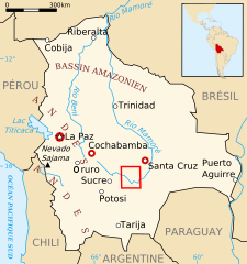
Français : Carte de la Bolivie avec les zones
d'activité de la guérilla dirigée par Che Guevara en 1966-1967 ( en rouge). |
| Date | |
| Source | self-made, samples were provided from commons maps : Image:LocationBolivia.svg, Image:Bolivie carte.gif and Image:Bolivia - Zona en que combatió Che Guevara.png (Pepe Robles work). |
| Author |
This W3C-unspecified vector image was created with Inkscape . |
| Permission (Reusing this file) |
Creative Commons Attribution ShareAlike license (See below). |
| Other versions |
 |
Licensing
[edit]
I, the copyright holder of this work, hereby publish it under the following licenses:

|
Permission is granted to copy, distribute and/or modify this document under the terms of the GNU Free Documentation License, Version 1.2 or any later version published by the Free Software Foundation; with no Invariant Sections, no Front-Cover Texts, and no Back-Cover Texts. A copy of the license is included in the section entitled GNU Free Documentation License. |
This file is licensed under the Creative Commons Attribution-Share Alike 3.0 Unported, 2.5 Generic, 2.0 Generic and 1.0 Generic license.
- You are free:
- to share – to copy, distribute and transmit the work
- to remix – to adapt the work
- Under the following conditions:
- attribution – You must give appropriate credit, provide a link to the license, and indicate if changes were made. You may do so in any reasonable manner, but not in any way that suggests the licensor endorses you or your use.
- share alike – If you remix, transform, or build upon the material, you must distribute your contributions under the same or compatible license as the original.
You may select the license of your choice.
File history
Click on a date/time to view the file as it appeared at that time.
| Date/Time | Thumbnail | Dimensions | User | Comment | |
|---|---|---|---|---|---|
| current | 00:33, 20 January 2019 | | 328 × 350 (296 KB) | Ras67 (talk | contribs) | frame removed, code optimized |
| 03:08, 3 November 2009 |  | 328 × 350 (503 KB) | Lilyu (talk | contribs) | Gruro => Oruro | |
| 18:28, 19 November 2007 |  | 328 × 350 (503 KB) | YassineMrabet (talk | contribs) | Conventions | |
| 11:39, 13 November 2007 |  | 328 × 350 (516 KB) | YassineMrabet (talk | contribs) | Corrections + conventions | |
| 16:57, 8 November 2007 |  | 328 × 350 (510 KB) | YassineMrabet (talk | contribs) | {{Information |Description={{fr|Carte de la w:fr:Bolivie avec les zones d'activité de la guérilla dirigée par Che Guevara en 1966-1967 ( en rouge). }} |Source=self-made, samples were provided from commons maps : Image:LocationBolivia.svg, [[ |
You cannot overwrite this file.
File usage on Commons
There are no pages that use this file.
File usage on other wikis
The following other wikis use this file:
- Usage on bg.wikipedia.org
- Usage on da.wikipedia.org
- Usage on fr.wikipedia.org
- Usage on gl.wikipedia.org
- Usage on no.wikipedia.org