File:Wpdms nasa photo san pablo bay.jpg
Jump to navigation
Jump to search
No higher resolution available.
Wpdms_nasa_photo_san_pablo_bay.jpg (534 × 467 pixels, file size: 91 KB, MIME type: image/jpeg)
Captions
Captions
Add a one-line explanation of what this file represents
Summary
[edit]
| Description |
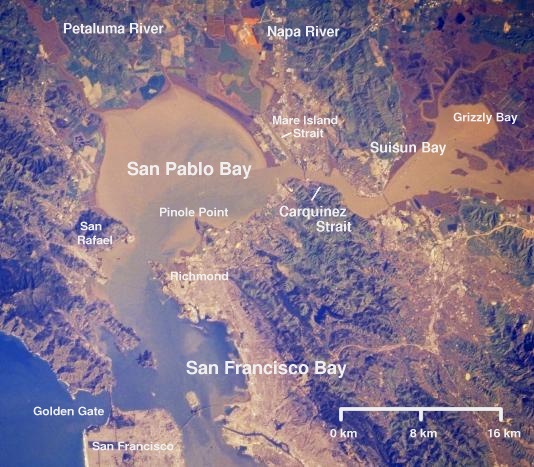
English: Satellite picture of San Pablo Bay, Carquinez Strait, and Suisun Bay - in the Category:San Francisco Bay Area, California.
|
| Date | 3 April 2004 (original upload date) |
| Source | Transferred from en.wikipedia to Commons by מתניה. |
| Author | The original uploader was Decumanus at English Wikipedia. |
Licensing
[edit]
| This file is licensed under the Creative Commons Attribution-Share Alike 3.0 Unported license. Subject to disclaimers. | ||
| ||
| This licensing tag was added to this file as part of the GFDL licensing update. |

|
Permission is granted to copy, distribute and/or modify this document under the terms of the GNU Free Documentation License, Version 1.2 or any later version published by the Free Software Foundation; with no Invariant Sections, no Front-Cover Texts, and no Back-Cover Texts. A copy of the license is included in the section entitled GNU Free Documentation License. Subject to disclaimers. |
Original upload log
[edit]
The original description page was here. All following user names refer to en.wikipedia.
- 2004-04-03 07:31 Decumanus 534×467× (93256 bytes) [[San Pablo Bay]], [[Carquinez Strait]], and [[Suisun Bay]] © 2004 Matthew Trump, adapted from public domain NASA satellite photo {{msg:GFDL}}
File history
Click on a date/time to view the file as it appeared at that time.
| Date/Time | Thumbnail | Dimensions | User | Comment | |
|---|---|---|---|---|---|
| current | 12:25, 24 November 2009 | | 534 × 467 (91 KB) | Matanya (talk | contribs) | {{Information |Description={{en|en:San Pablo Bay, en:Carquinez Strait, and en:Suisun Bay © 2004 Matthew Trump, adapted from public domain NASA satellite photo}} |Source=Transferred from [http://en.wikipedia.org en.wikipedia]; transfer w |
You cannot overwrite this file.
File usage on Commons
There are no pages that use this file.
File usage on other wikis
The following other wikis use this file:
- Usage on bn.wikipedia.org
- Usage on ceb.wikipedia.org
- Usage on en.wikipedia.org
- Usage on es.wikipedia.org
- Usage on fr.wikipedia.org
- Usage on he.wikipedia.org
- Usage on it.wikipedia.org
- Usage on ja.wikipedia.org
- Usage on nl.wikipedia.org
- Usage on pt.wikipedia.org
- Usage on ru.wikipedia.org
- Usage on sh.wikipedia.org
- Usage on www.wikidata.org
Metadata
Categories:
- Bays of California
- Aerial photographs of San Francisco Bay
- Suisun Bay
- Satellite pictures of bays
- Satellite pictures of straits
- Straits of the United States
- Wetlands of California
- Estuaries of the United States
- Satellite pictures of the San Francisco Bay Area
- Nature of the San Francisco Bay Area
- Sacramento–San Joaquin River Delta
- San Pablo Bay
- Annotated satellite pictures of North America