File:Topographical map of Wyoming Co., Pennsylvania - from recent and actual surveys and records LOC 2012592227.tif
Jump to navigation
Jump to search

Size of this JPG preview of this TIF file: 800 × 517 pixels. Other resolutions: 320 × 207 pixels | 640 × 414 pixels | 1,024 × 662 pixels | 1,280 × 827 pixels | 2,560 × 1,654 pixels | 18,921 × 12,225 pixels.
Original file (18,921 × 12,225 pixels, file size: 661.78 MB, MIME type: image/tiff)
Captions
Captions
Add a one-line explanation of what this file represents
Summary
[edit]| Warning | The original file is very high-resolution. It might not load properly or could cause your browser to freeze when opened at full size. |
|---|
| Description |
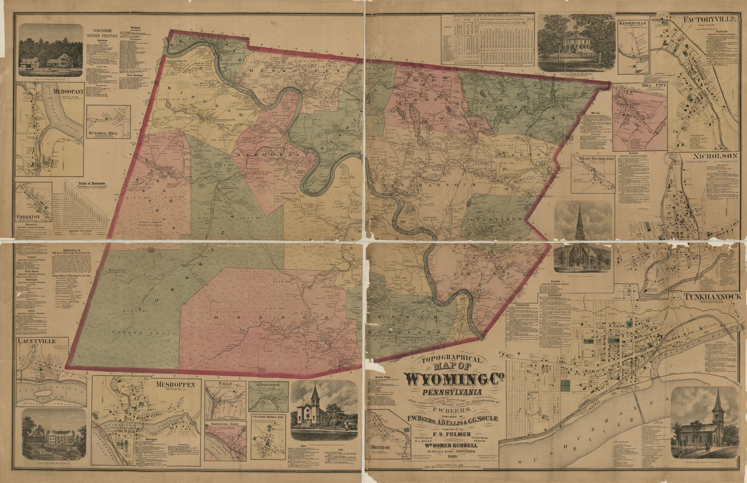
English: General-content county map also showing rural buildings, householders' names, and forested areas; some town insets also show real-property tracts, landowners' names, and building coverage. "Published by F.W. Beers, A.D. Ellis & G.G. Soule assisted by F.S. Fulmer ... [et al.] .. Wm. Homer Hubbell ... New York." Hand col. to emphasize township boundaries and territories. "Entered according to Act of Congress in the year 1869 by Beers, Ellis & Soule ... in the Southern District of New York." LC copy imperfect: Darkened, brittle, quartered to enable folding, missing small sections at fold lines/margins/edges; copy 2 also annotated in black ink and lead pencil. Includes business directories, index to Tunkhannock points of interest, statistical table, and ill. Town and village insets: Tunkhannock -- Nicholson -- Factoryville -- Monroe -- Jenningsville -- Centre Moreland -- Falls -- Skinners Eddy -- Meshoppen -- Laceyville -- Forkston -- Mehoopany -- Russell Hill -- Keiserville -- Mill City -- West Nicholson. LC Land ownership maps, 822 Available also through the Library of Congress Web site as a raster image. 2 copies |
||
| Title | Topographical map of Wyoming Co., Pennsylvania : from recent and actual surveys and records | ||
| Shelf ID | G3823.W9 1869 .B4 G3823.W9 1869 .B4 Copy 2 | ||
| Date | |||
| Source | https://www.loc.gov/item/2012592227/ | ||
| Author | Beers, F. W. (Frederick W.); Fulmer, F. S.; Hubbell, Wm. Homer (William Homer); Mcguigan, James; Worley & Bracher; Beers, F. W. | ||
| Permission (Reusing this file) |
|
||
| Other versions |
|
||
| Location | Wyoming County · Pennsylvania · Tunkhannock · Nicholson · United States · Factoryville (Wyoming County) · Factoryville | ||
| Part of | American Memory · Catalog · County Landownership Maps · Geography And Map Division · Cultural Landscapes | ||
| Subject | Nicholson (Pa.) · Factoryville (Wyoming County) · Wyoming County · Tunkhannock (Pa.) · Pennsylvania · Cities And Towns · Villages · Nicholson · United States · Maps · Tunkhannock · Wyoming County (Pa.) · Real Property · Factoryville (Wyoming County, Pa.) · Landowners |


Licensing
[edit]|
This is a faithful photographic reproduction of a two-dimensional, public domain work of art. The work of art itself is in the public domain for the following reason:
The official position taken by the Wikimedia Foundation is that "faithful reproductions of two-dimensional public domain works of art are public domain".
This photographic reproduction is therefore also considered to be in the public domain in the United States. In other jurisdictions, re-use of this content may be restricted; see Reuse of PD-Art photographs for details. | ||||
File history
Click on a date/time to view the file as it appeared at that time.
| Date/Time | Thumbnail | Dimensions | User | Comment | |
|---|---|---|---|---|---|
| current | 10:13, 23 June 2018 |  | 18,921 × 12,225 (661.78 MB) | Fæ (talk | contribs) | LOC Maps https://www.loc.gov/item/2012592227/ #25348 |
You cannot overwrite this file.
File usage on Commons
The following page uses this file: