File:The battle of Moores Creek Bridge, February 27, 1776. 1964. LOC 73695954.tif
Jump to navigation
Jump to search

Size of this JPG preview of this TIF file: 643 × 599 pixels. Other resolutions: 258 × 240 pixels | 515 × 480 pixels | 824 × 768 pixels | 1,099 × 1,024 pixels | 2,198 × 2,048 pixels | 6,117 × 5,700 pixels.
Original file (6,117 × 5,700 pixels, file size: 99.76 MB, MIME type: image/tiff)
Captions
Captions
Add a one-line explanation of what this file represents
Summary
[edit]| Description |
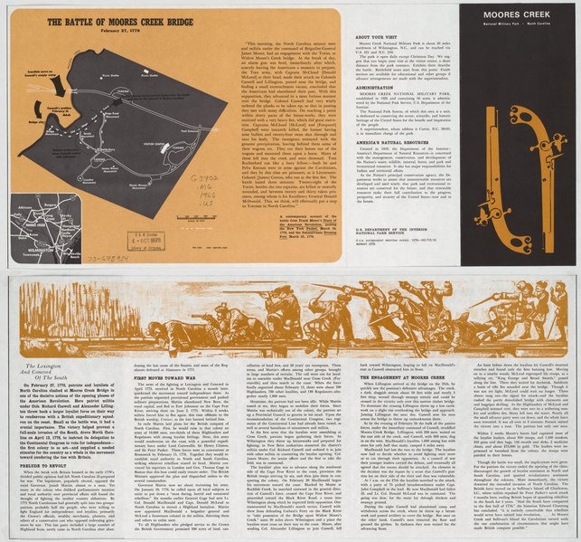
English: Scale ca. 1:3,650. Folded title: Moores Creek National Military Park, North Carolina. "NMP-MC-17002." Includes location map and text. Text on verso. Available also through the Library of Congress Web site as a raster image. AACR2 |
||
| Title | The battle of Moores Creek Bridge, February 27, 1776. 1964. | ||
| Shelf ID | G3902.M6 1966 .U5 | ||
| Date | |||
| Source | https://www.loc.gov/item/73695954/ | ||
| Author | United States. National Park Service | ||
| Permission (Reusing this file) |
|
||
| Other versions |
|
||
| Location | United States · Moores Creek National Military Battlefield · Moores Creek National Battlefield. · Moores Creek National Battlefield · North Carolina | ||
| Part of | American Memory · General Maps · Catalog · Geography And Map Division | ||
| Subject | Moores Creek National Military Battlefield (N.C.) · Moores Creek National Battlefield · Moores Creek National Battlefield (N.C.) · North Carolina · United States · Maps |


Licensing
[edit]| This image or media file contains material based on a work of a National Park Service employee, created as part of that person's official duties. As a work of the U.S. federal government, such work is in the public domain in the United States. See the NPS website and NPS copyright policy for more information. |
File history
Click on a date/time to view the file as it appeared at that time.
| Date/Time | Thumbnail | Dimensions | User | Comment | |
|---|---|---|---|---|---|
| current | 14:26, 22 September 2018 |  | 6,117 × 5,700 (99.76 MB) | Fæ (talk | contribs) | LOC Maps https://www.loc.gov/item/73695954/ #2761 |
You cannot overwrite this file.
File usage on Commons
The following page uses this file: