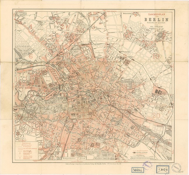
File:Straube Taschenplan von Berlin 1896.jpg

Original file (4,268 × 3,953 pixels, file size: 6.24 MB, MIME type: image/jpeg)
Captions
Captions
Summary
[edit]| Title |
Taschenplan von Berlin |
|||||||||
| DescriptionStraube Taschenplan von Berlin 1896.jpg |
Deutsch: Datiert nach dem Schlüssel unten rechts im Plan: "69.2." |
|||||||||
| Date | ||||||||||
| Source | http://chartae-antiquae.cz/en/maps/32526 | |||||||||
| Creator | ||||||||||
| Geotemporal data | ||||||||||
| Map location | Berlin | |||||||||
| Scale | 1:32,500 | |||||||||
| Heading |
|
|||||||||
| Bounding box |
|
|||||||||
| Georeferencing | Georeference the map in Wikimaps Warper If inappropriate please set warp_status = skip to hide. | |||||||||
| Bibliographic data | ||||||||||
| Language | German | |||||||||
| Publisher |
Geographisches Institut und Landkartenverlag Julius Straube |
|||||||||
| Printed by |
C.L. Keller Berlin |
|||||||||
| Archival data | ||||||||||
| Collection | Národní technické muzeum (National Technical Museum (Prague)) | |||||||||
| Dimensions |
height: 30 cm (11.8 in); width: 31 cm (12.2 in) dimensions QS:P2048,30.0U174728 dimensions QS:P2049,31.0U174728 (height: 28.6 cm (11.2 in); width: 30 cm (11.8 in)dimensions QS:P2048,28.6U174728 dimensions QS:P2049,30.0U174728 ) |
|||||||||
| Notes |
Literatur
|
|||||||||
Licensing
[edit]| Public domainPublic domainfalsefalse |
|
This work is in the public domain in its country of origin and other countries and areas where the copyright term is the author's life plus 70 years or fewer. Note that a few countries have copyright terms longer than 70 years: Mexico has 100 years, Jamaica has 95 years, Colombia has 80 years, and Guatemala and Samoa have 75 years. This image may not be in the public domain in these countries, which moreover do not implement the rule of the shorter term. Honduras has a general copyright term of 75 years, but it does implement the rule of the shorter term. Copyright may extend on works created by French who died for France in World War II (more information), Russians who served in the Eastern Front of World War II (known as the Great Patriotic War in Russia) and posthumously rehabilitated victims of Soviet repressions (more information).
| |
| This file has been identified as being free of known restrictions under copyright law, including all related and neighboring rights. | |
https://creativecommons.org/publicdomain/mark/1.0/PDMCreative Commons Public Domain Mark 1.0falsefalse
File history
Click on a date/time to view the file as it appeared at that time.
| Date/Time | Thumbnail | Dimensions | User | Comment | |
|---|---|---|---|---|---|
| current | 22:16, 29 December 2015 |  | 4,268 × 3,953 (6.24 MB) | Alexrk2 (talk | contribs) | == {{int:description}} == {{Map |title='''Taschenplan von Berlin''' |description={{de|Datiert nach dem Schlüssel unten rechts im Plan: "69.2."}} |legend= |author=de:Julius Straube |date=1896 |source=http://chartae-antiquae.cz/en/maps/32526 |permi... |
You cannot overwrite this file.
File usage on Commons
The following page uses this file:
Metadata
This file contains additional information such as Exif metadata which may have been added by the digital camera, scanner, or software program used to create or digitize it. If the file has been modified from its original state, some details such as the timestamp may not fully reflect those of the original file. The timestamp is only as accurate as the clock in the camera, and it may be completely wrong.
| Width | 4,268 px |
|---|---|
| Height | 3,953 px |
| Bits per component |
|
| Pixel composition | RGB |
| Orientation | Normal |
| Number of components | 3 |
| Horizontal resolution | 72 dpi |
| Vertical resolution | 72 dpi |
| Software used | Adobe Photoshop CS5.1 Windows |
| File change date and time | 17:45, 25 December 2015 |
| Exif version | 2.21 |
| Color space | Uncalibrated |
| Date and time of digitizing | 23:35, 23 December 2015 |
| Date metadata was last modified | 18:45, 25 December 2015 |
| Unique ID of original document | xmp.did:A4488AE50AABE5118363ADFB71BD81F4 |