File:Sinai-peninsula-map.jpg
Jump to navigation
Jump to search

Size of this preview: 483 × 600 pixels. Other resolutions: 193 × 240 pixels | 387 × 480 pixels | 941 × 1,168 pixels.
Original file (941 × 1,168 pixels, file size: 665 KB, MIME type: image/jpeg)
Captions
Captions
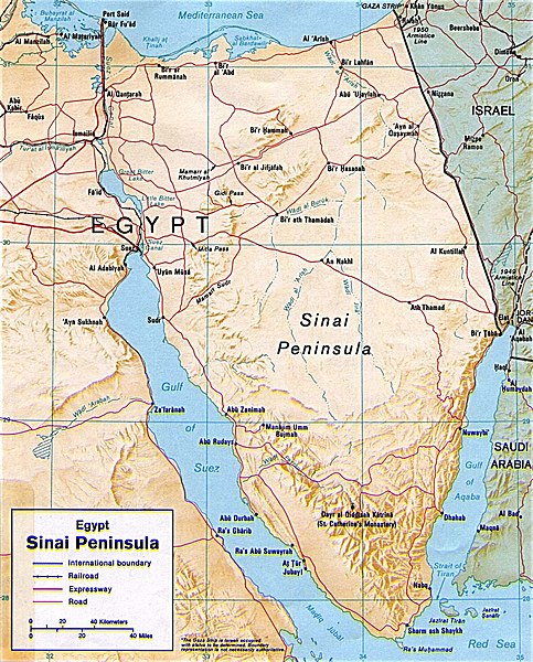
The Sinai peninsula, which was occupied by Israel after the Six day war
فلسطين
Summary
[edit]| Description | Shaded relief map of the Sinai Peninsula, 1992, produced by the U.S. Central Intelligence Agency. |
| Date | |
| Source | University of Texas Libraries, Perry-Castañeda Library Map Collection: Egypt Maps |
| Author | CIA |
| Other versions |
|
| Openstreetmap entry | Link to Openstreetmap |


| Object location | | View this and other nearby images on: OpenStreetMap |
|---|
Licensing
[edit]
| This image is a work of a Central Intelligence Agency employee, taken or made as part of that person's official duties. As a Work of the United States Government, this image or media is in the public domain in the United States.
|

|
File history
Click on a date/time to view the file as it appeared at that time.
| Date/Time | Thumbnail | Dimensions | User | Comment | |
|---|---|---|---|---|---|
| current | 20:45, 12 May 2011 | | 941 × 1,168 (665 KB) | Ras67 (talk | contribs) | cropped |
| 22:58, 4 March 2007 |  | 956 × 1,196 (307 KB) | Joao Xavier (talk | contribs) | Map of the Sinai Peninsula. (U.S. Central Intelligence Agency, https://www.cia.gov/cia/publications/mapspub/index.shtml) originally found on University of Texas library website (http://www.lib.utexas.edu/maps/middle_east_and_asia/sinai.jpg) and claimed as |
You cannot overwrite this file.
File usage on Commons
The following 5 pages use this file:
File usage on other wikis
The following other wikis use this file:
- Usage on af.wikipedia.org
- Usage on als.wikipedia.org
- Usage on ar.wikipedia.org
- Usage on ast.wikipedia.org
- Usage on azb.wikipedia.org
- Usage on az.wikipedia.org
- Usage on az.wiktionary.org
- Usage on ba.wikipedia.org
- Usage on bn.wikipedia.org
- Usage on bs.wikipedia.org
- Usage on ca.wikipedia.org
- Usage on cs.wikipedia.org
- Usage on da.wikipedia.org
- Usage on de.wikipedia.org
- Usage on de.wikinews.org
- Usage on de.wiktionary.org
- Usage on diq.wikipedia.org
- Usage on el.wikipedia.org
- Usage on el.wiktionary.org
- Usage on en.wikipedia.org
- Sinai Peninsula
- Battle of Romani
- 2004 Sinai bombings
- Ras Burqa massacre
- Operation Eagle
- Egyptian Crisis (2011–2014)
- Template:Did you know nominations/Operation Eagle
- Operation Sinai (2012)
- File talk:Sinai-peninsula-map.jpg
- 2014 Taba bus bombing
- Talk:2014 Taba bus bombing
- Operation Martyr's Right
- Israel-Palestine conflict solutions
- Usage on eo.wikipedia.org
- Usage on es.wikipedia.org
View more global usage of this file.