File:Sanborn Fire Insurance Map from South Bend, Saint Joseph County, Indiana. LOC sanborn02502 004-69.tif
Jump to navigation
Jump to search

Size of this JPG preview of this TIF file: 509 × 599 pixels. Other resolutions: 204 × 240 pixels | 407 × 480 pixels | 652 × 768 pixels | 869 × 1,024 pixels | 1,739 × 2,048 pixels | 6,719 × 7,913 pixels.

Original file (6,719 × 7,913 pixels, file size: 152.18 MB, MIME type: image/tiff, 2 pages)
Captions
Captions
Add a one-line explanation of what this file represents
Summary
[edit]| Description |
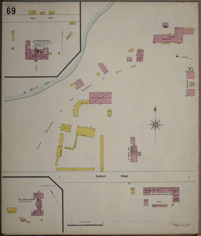
English: 1899. 75 Sheet(s). Bound. |
||
| Title | Sanborn Fire Insurance Map from South Bend, Saint Joseph County, Indiana. | ||
| Shelf ID | https://www.loc.gov/item/sanborn02502_004/ | ||
| Parent | https://www.loc.gov/resource/g4094sm.g4094sm_g025021899/ | ||
| Sheet title | Image 1 of Sanborn Fire Insurance Map from South Bend, Saint Joseph County, Indiana. | ||
| Date | |||
| Source | https://www.loc.gov/item/sanborn02502_004/ | ||
| Author | Unknown author | ||
| Permission (Reusing this file) |
|
||
| Other versions |
|
||
| Location | Indiana · South Bend · Saint Joseph County | ||
| Part of | American Memory · Sanborn Maps · Geography And Maps Division |

Licensing
[edit]|
This is a faithful photographic reproduction of a two-dimensional, public domain work of art. The work of art itself is in the public domain for the following reason:
The official position taken by the Wikimedia Foundation is that "faithful reproductions of two-dimensional public domain works of art are public domain".
This photographic reproduction is therefore also considered to be in the public domain in the United States. In other jurisdictions, re-use of this content may be restricted; see Reuse of PD-Art photographs for details. | ||||
File history
Click on a date/time to view the file as it appeared at that time.
| Date/Time | Thumbnail | Dimensions | User | Comment | |
|---|---|---|---|---|---|
| current | 22:10, 19 July 2022 |  | 6,719 × 7,913, 2 pages (152.18 MB) | Eccekevin (talk | contribs) | Uploaded a work by {{Unknown|1=Author}} from https://www.loc.gov/item/sanborn02502_004/ with UploadWizard |
You cannot overwrite this file.
File usage on Commons
The following 2 pages use this file: