File:PAEONIAN ARDIAEAN (ILLYRIAN) DARDANIAN KINGDOMS EXTENT DURING 230 BC.png
Jump to navigation
Jump to search
Size of this preview: 671 × 600 pixels. Other resolutions: 268 × 240 pixels | 537 × 480 pixels | 859 × 768 pixels | 1,049 × 938 pixels.
Original file (1,049 × 938 pixels, file size: 1.88 MB, MIME type: image/png)
Captions
Captions
Add a one-line explanation of what this file represents
Summary
[edit]_DARDANIAN_KINGDOMS_EXTENT_DURING_230_BC.png&action=edit§ion=1)
| Description |
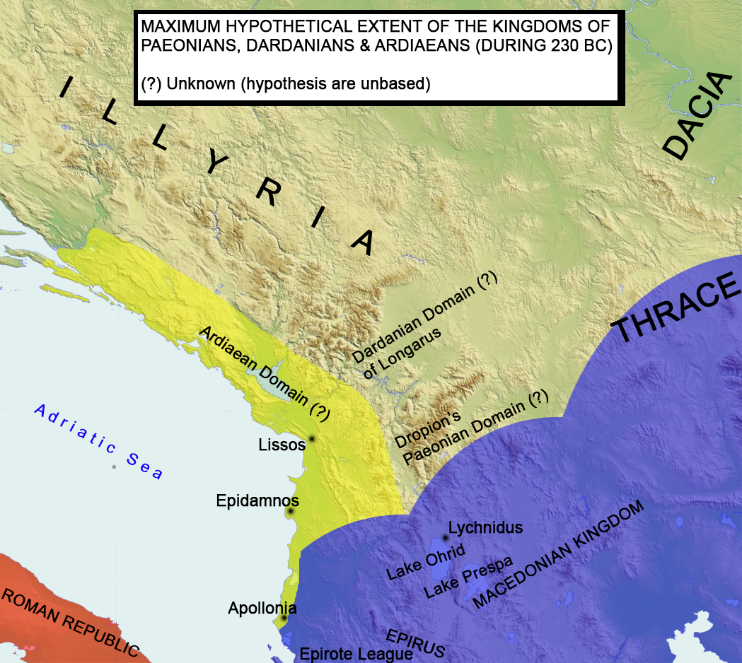
English: Paeonian, Ardiaean (Ilyrian), Dardanian kingdoms extent during 230 BC. Maximum hypothetical extent.
Français : Extension hypothétique du royaume illyrien vers 230 av. J.-C.. |
| Date | |
| Source | Own work |
| Author | MaryroseB54 |
- Epire, Illyrie, Macedoine: melanges offerts au professeur Pierre Cabanes by Daniele Berranger,Pierre Cabanes,Daniele Berranger-Auserve,page 136,"The extent of the kingdom of Agron and Teuta is not known exactly"
- Studies concerning Epirus and Macedonia before Alexander by Nicholas Geoffrey Lempriere Hammond, concludes that Agron's domain was of regional significance only and if he even called himself king of the Illyrians is questioned.That he was an Ardiaean king and he extented his rule into other tribes as well, but thats it.
- A History of Macedonia: 336-167 B.C By Nicholas Geoffrey Lempriere Hammond, Frank William Walbank,1988,ISBN -0198148151
- Epire, Illyrie, Macedoine: melanges offerts au professeur Pierre Cabanes by Daniele Berranger,Pierre Cabanes,Daniele Berranger-Auserve
- The Illyrians by J. J. Wilkes,1992,ISBN 0631198075,
- Epirus, 4000 years of Greek history and civilization by M. B. Hatzopoulos
- Diadokhoi Maps by Mladjov (see here) of http://umich.edu/ University of Michigan
- Blank map,File:Yugoslavia_topographic_base_map.svg
Licensing
[edit]_DARDANIAN_KINGDOMS_EXTENT_DURING_230_BC.png&action=edit§ion=2)
I, the copyright holder of this work, hereby publish it under the following license:
This file is licensed under the Creative Commons Attribution-Share Alike 4.0 International license.
- You are free:
- to share – to copy, distribute and transmit the work
- to remix – to adapt the work
- Under the following conditions:
- attribution – You must give appropriate credit, provide a link to the license, and indicate if changes were made. You may do so in any reasonable manner, but not in any way that suggests the licensor endorses you or your use.
- share alike – If you remix, transform, or build upon the material, you must distribute your contributions under the same or compatible license as the original.
| Annotations | This image is annotated: View the annotations at Commons |
_DARDANIAN_KINGDOMS_EXTENT_DURING_230_BC.png)
File history
Click on a date/time to view the file as it appeared at that time.
| Date/Time | Thumbnail | Dimensions | User | Comment | |
|---|---|---|---|---|---|
| current | 13:14, 13 July 2016 | | 1,049 × 938 (1.88 MB) | MaryroseB54 (talk | contribs) | Epirote League, Epirus |
| 12:05, 13 July 2016 |  | 1,049 × 938 (1.88 MB) | MaryroseB54 (talk | contribs) | User created page with UploadWizard |
You cannot overwrite this file.
File usage on Commons
The following 5 pages use this file:
File usage on other wikis
The following other wikis use this file:
- Usage on bs.wikipedia.org
- Usage on da.wikipedia.org
- Usage on fr.wikipedia.org
- Usage on ja.wikipedia.org
- Usage on pl.wikipedia.org
- Usage on sq.wikipedia.org
- Usage on sv.wikipedia.org
- Usage on uk.wikipedia.org
Metadata
_DARDANIAN_KINGDOMS_EXTENT_DURING_230_BC.png&oldid=698042225)
Categories:
- Maps of the ancient Kingdom of Illyria
- Antigonid dynasty
- Maps of the Hellenistic world
- Maps of the history of the ancient Balkans
- Maps of the history of Albania in ancient times
- Maps of the history of Kosovo in ancient times
- Maps of the history of Montenegro in ancient times
- Maps of the history of Croatia in ancient times
- Maps of the history of Dalmatia
- Maps showing 3rd-century BC history
- 230s BC
- 220s BC
- Agron of Illyria
- Kingdom of Dardania