File:Péninsule ibérique en 1065.png
Jump to navigation
Jump to search

Size of this preview: 800 × 600 pixels. Other resolutions: 320 × 240 pixels | 640 × 480 pixels | 1,024 × 768 pixels | 1,280 × 960 pixels | 2,000 × 1,500 pixels.
Original file (2,000 × 1,500 pixels, file size: 1,014 KB, MIME type: image/png)
Captions
Captions
Add a one-line explanation of what this file represents
Summary
[edit]
| Description |
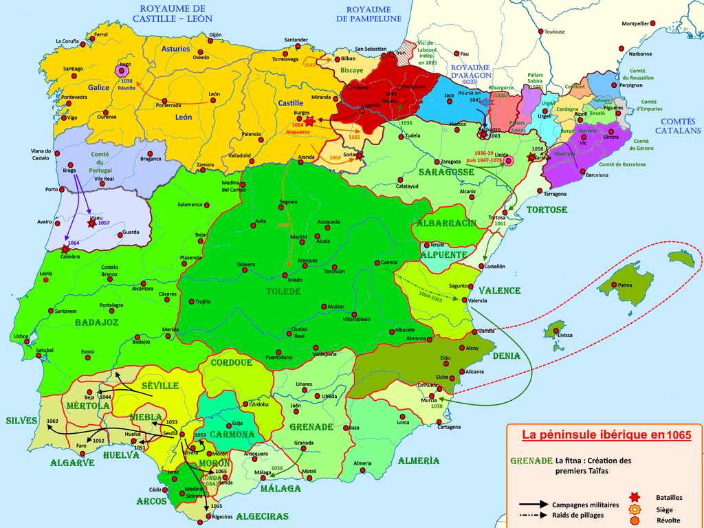
Français : Carte de la péninsule ibérique de 1037 à 1065 illustrant les principaux évènements de la période |
| Date | |
| Source | Own work |
| Author | Elryck |
Licensing
[edit]
I, the copyright holder of this work, hereby publish it under the following license:
This file is licensed under the Creative Commons Attribution-Share Alike 4.0 International license.
- You are free:
- to share – to copy, distribute and transmit the work
- to remix – to adapt the work
- Under the following conditions:
- attribution – You must give appropriate credit, provide a link to the license, and indicate if changes were made. You may do so in any reasonable manner, but not in any way that suggests the licensor endorses you or your use.
- share alike – If you remix, transform, or build upon the material, you must distribute your contributions under the same or compatible license as the original.
File history
Click on a date/time to view the file as it appeared at that time.
| Date/Time | Thumbnail | Dimensions | User | Comment | |
|---|---|---|---|---|---|
| current | 20:39, 17 August 2020 | | 2,000 × 1,500 (1,014 KB) | Elryck (talk | contribs) | Ajout de Pallars Jussa |
| 19:20, 17 August 2020 |  | 2,000 × 1,500 (1,011 KB) | Elryck (talk | contribs) | Nomenclatures | |
| 21:51, 14 August 2020 |  | 2,000 × 1,500 (1 MB) | Elryck (talk | contribs) | Correction des frontières autour de Soria | |
| 12:57, 13 August 2020 |  | 2,000 × 1,500 (1 MB) | Elryck (talk | contribs) | Correction de la légende corrompue lors d'une sauvegarde | |
| 11:57, 13 August 2020 |  | 2,000 × 1,500 (1.01 MB) | Elryck (talk | contribs) | Version 1.0 | |
| 17:12, 12 August 2020 |  | 2,000 × 1,500 (1.01 MB) | Elryck (talk | contribs) | Uploaded own work with UploadWizard |
You cannot overwrite this file.
File usage on Commons
The following page uses this file:
File usage on other wikis
The following other wikis use this file:
- Usage on an.wikipedia.org
- Usage on en.wikipedia.org
- Usage on es.wikipedia.org
- Usage on fr.wikipedia.org
- Royaume d'Aragon
- Ferdinand Ier (roi de Castille et de Leon)
- Première période de taïfas
- Royaume de Castille
- Royaume de Navarre
- Royaume de León
- Comtés catalans
- Histoire d'al-Andalus
- Ramire Ier (roi d'Aragon)
- Taïfa de Séville
- Comté de Portugal
- Sanche IV (roi de Pampelune)
- García IV (roi de Pampelune)
- Hammudites
- Reconquista
- Raimond-Bérenger Ier de Barcelone
- Royaume de Pampelune
- Histoire de l'Aragon
- Isabelle d'Urgell
- Taïfa de Tolède
- Portugal à la Reconquista
- Usage on gl.wikipedia.org
- Usage on it.wikipedia.org
- Usage on pt.wikipedia.org
Metadata
Categories:
- French-language maps showing history of Europe
- Maps of 11th-century Iberian Peninsula
- Reconquista maps of the Iberian Peninsula
- Iberian kingdoms
- Maps of Al-Andalus
- Maps of León
- Maps of Aragon
- Maps of Navarre
- Maps of the County of Barcelona
- Maps of Catalan counties
- Maps of the taifa kingdoms
- Territorial evolution of Spain
- Spain in the 1060s