File:Oestliche Westalpen.svg
Jump to navigation
Jump to search

Size of this PNG preview of this SVG file: 623 × 599 pixels. Other resolutions: 250 × 240 pixels | 499 × 480 pixels | 798 × 768 pixels | 1,064 × 1,024 pixels | 2,129 × 2,048 pixels | 2,341 × 2,252 pixels.
Original file (SVG file, nominally 2,341 × 2,252 pixels, file size: 3.29 MB)
Captions
Captions
Add a one-line explanation of what this file represents
| Description |
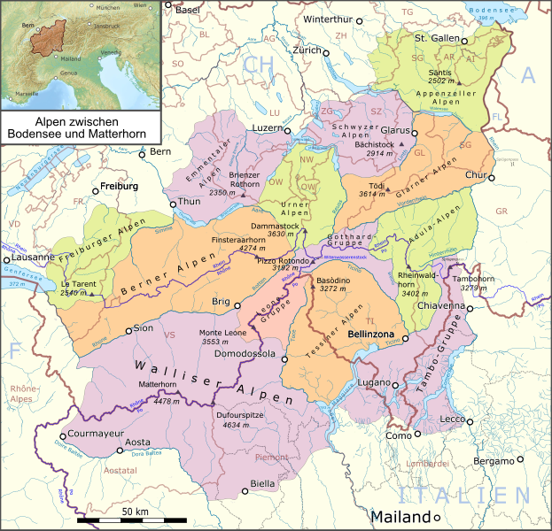
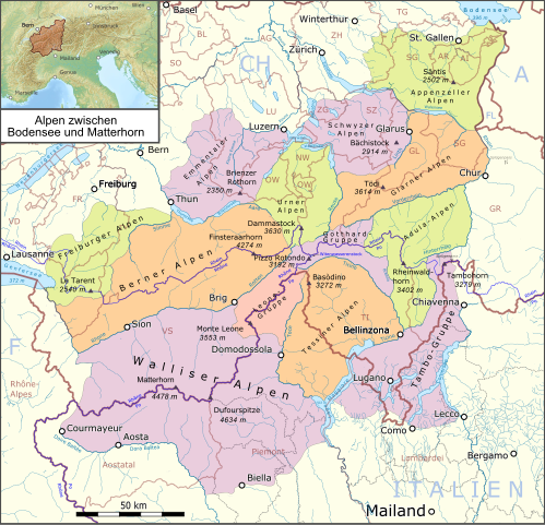
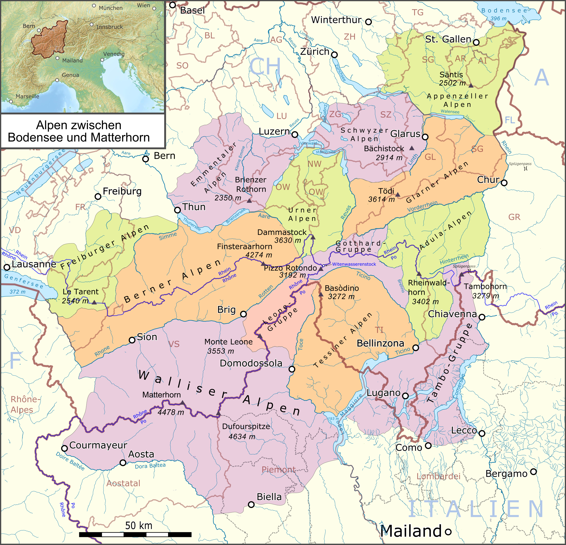
Deutsch: Lagekarte der östlichen Westalpen |
|||||||||
| Date | ||||||||||
| Source |
Own work Map was created using:
|
|||||||||
| Creator | ||||||||||
| Permission (Reusing this file) |
Map data (c) OpenStreetMap (and) contributors, CC-BY-SA | |||||||||
| Geotemporal data | ||||||||||
| Bounding box |
|
|||||||||
This file is licensed under the Creative Commons Attribution-Share Alike 2.0 Generic license.
- You are free:
- to share – to copy, distribute and transmit the work
- to remix – to adapt the work
- Under the following conditions:
- attribution – You must give appropriate credit, provide a link to the license, and indicate if changes were made. You may do so in any reasonable manner, but not in any way that suggests the licensor endorses you or your use.
- share alike – If you remix, transform, or build upon the material, you must distribute your contributions under the same or compatible license as the original.
File history
Click on a date/time to view the file as it appeared at that time.
| Date/Time | Thumbnail | Dimensions | User | Comment | |
|---|---|---|---|---|---|
| current | 23:10, 12 January 2019 | | 2,341 × 2,252 (3.29 MB) | Pechristener (talk | contribs) | neues Farbschema |
| 10:40, 12 January 2019 |  | 2,341 × 2,252 (3.29 MB) | Pechristener (talk | contribs) | Titel geändert, Matterhorn hinzu | |
| 06:12, 3 June 2017 |  | 2,341 × 2,252 (3.27 MB) | Pechristener (talk | contribs) | korr location map, Mailand & Bergamo added, svg improved | |
| 16:34, 30 August 2015 |  | 2,341 × 2,252 (2.18 MB) | Pechristener (talk | contribs) | Wasserscheiden Rhein—Rhone und Rhone—Po hinzu | |
| 21:20, 11 March 2015 |  | 2,341 × 2,252 (2.08 MB) | Pechristener (talk | contribs) | Grenzen im Bodensee entfernt | |
| 21:47, 9 March 2015 |  | 2,341 × 2,252 (2.08 MB) | Pechristener (talk | contribs) | einige Verbesserungen gem KW | |
| 19:33, 3 March 2015 |  | 2,341 × 2,252 (2.07 MB) | Pechristener (talk | contribs) | - Bezeichnung FL bie Fürstentum Lichtenstein eingefügt - Basòdino statt Monte Basòdino | |
| 07:30, 28 February 2015 |  | 2,341 × 2,252 (2.07 MB) | Pechristener (talk | contribs) | Location map and map scale ruler added / highest moutain of Firbourg Alps corr / blank areas between border lines removed / border lines of Appenzeller Alpen fixed | |
| 23:43, 22 February 2015 |  | 2,341 × 2,252 (1.6 MB) | Pechristener (talk | contribs) | Beschriftung repariert (svg-Problem) | |
| 23:18, 22 February 2015 |  | 2,341 × 2,252 (1.59 MB) | Pechristener (talk | contribs) | {{Information |Description={{de|1=Lagekarte der östlichen Westalpen}} |Source ={{own}} Map was created using: *[http://www.openstreetmap.org/ Open Street Map] |Author = *Pechristener |D... |
You cannot overwrite this file.
File usage on Commons
The following 5 pages use this file:
File usage on other wikis
The following other wikis use this file:
- Usage on als.wikipedia.org
- Usage on de.wikipedia.org
- Berner Alpen
- Walliser Alpen
- Westalpen
- Glarner Alpen
- Appenzeller Alpen
- Tessiner Alpen
- Urner Alpen
- Emmentaler Alpen
- Adula-Alpen
- Waadtländer und Freiburger Voralpen (SOIUSA)
- Benutzer Diskussion:Pechristener/Archiv/1
- Schwyzer Alpen
- Benutzer:FkMohr/Gebirge/Westalpen
- Diskussion:Tessiner Alpen
- Tambogruppe
- Gotthard-Gruppe
- Leone-Gruppe
- Vorlage:Positionskarte Europa Oestliche Westalpen
- Benutzer:FkMohr/Baustelle/Test
- Wikipedia:Kartenwerkstatt/Archiv/Zurückgewiesene und zurückgestellte Aufträge 2016
- Liste der Gebirgsgruppen in den Westalpen
- Vorlage:Navigationsleiste Östliche Westalpen
- Usage on eo.wikipedia.org
- Usage on hu.wikipedia.org
- Usage on rm.wikipedia.org
- Usage on sl.wikipedia.org