File:Ocean currents 1943.png
Jump to navigation
Jump to search
Size of this preview: 800 × 426 pixels. Other resolutions: 320 × 170 pixels | 640 × 341 pixels | 1,024 × 546 pixels | 1,280 × 682 pixels | 2,639 × 1,406 pixels.
Original file (2,639 × 1,406 pixels, file size: 4.89 MB, MIME type: image/png)
Captions
Captions
Add a one-line explanation of what this file represents

Summary
[edit]
| Description |
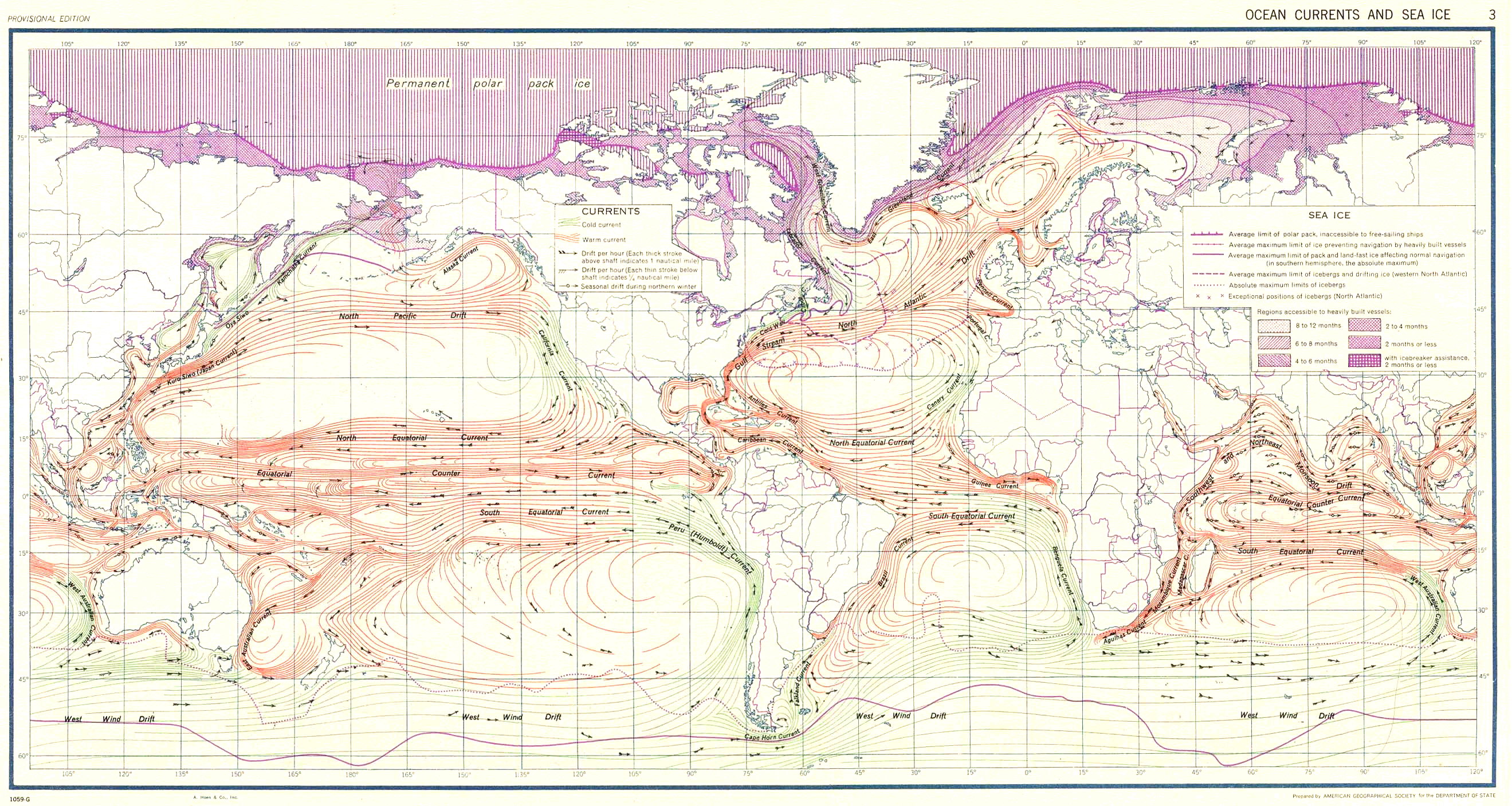
English: Modification of http://www.lib.utexas.edu/maps/world_maps/ocean_currents_1943.jpg by en:User:Dreg743 to show only the ocean currents.
Suomi: Maailman pintamerivirrat |
| Date | |
| Source | Modified version of Ocean Currents and Sea Ice from Atlas of World Maps. United States Army Service Forces, Army Specialized Training Division. Army Service Forces Manual M-101. 1943 from Perry-Castañeda LibraryMap CollectionWorld Maps |
| Author |
Original: United States Army Service Forces Derivative work: en:User:Dreg743 |
| Permission (Reusing this file) |
Public domain |
Licensing
[edit]
This file is a work of a U.S. Army soldier or employee, taken or made as part of that person's official duties. As a work of the U.S. federal government, it is in the public domain in the United States.
|
 |
This file is licensed under the Creative Commons Attribution-Share Alike 2.5 Generic license.
- You are free:
- to share – to copy, distribute and transmit the work
- to remix – to adapt the work
- Under the following conditions:
- attribution – You must give appropriate credit, provide a link to the license, and indicate if changes were made. You may do so in any reasonable manner, but not in any way that suggests the licensor endorses you or your use.
- share alike – If you remix, transform, or build upon the material, you must distribute your contributions under the same or compatible license as the original.
File history
Click on a date/time to view the file as it appeared at that time.
| Date/Time | Thumbnail | Dimensions | User | Comment | |
|---|---|---|---|---|---|
| current | 01:30, 6 April 2008 | | 2,639 × 1,406 (4.89 MB) | Jrockley (talk | contribs) | better version |
| 19:08, 11 March 2007 |  | 2,639 × 1,406 (1.47 MB) | Hautala (talk | contribs) | {{PD-PCL|ocean_currents_1943.jpg|world_maps/}} {{cc-by-sa-2.5}} * {{fi|Maailman pintamerivirrat}} * {{en|Ocean currents of the world}} Modification of [http://www.lib.utexas.edu/maps/world_maps/ocean_currents_1943.jpg] by en:User:Dreg743 to show on |
You cannot overwrite this file.
File usage on Commons
The following page uses this file:
File usage on other wikis
The following other wikis use this file:
- Usage on ceb.wikipedia.org
- Usage on en.wikipedia.org
- Usage on fi.wikipedia.org
- Usage on it.wikipedia.org