File:Nouvelle-Calédonie répartition culture 2012.svg
Jump to navigation
Jump to search

Size of this PNG preview of this SVG file: 708 × 591 pixels. Other resolutions: 288 × 240 pixels | 575 × 480 pixels | 920 × 768 pixels | 1,227 × 1,024 pixels | 2,454 × 2,048 pixels.
Original file (SVG file, nominally 708 × 591 pixels, file size: 181 KB)
Captions
Captions
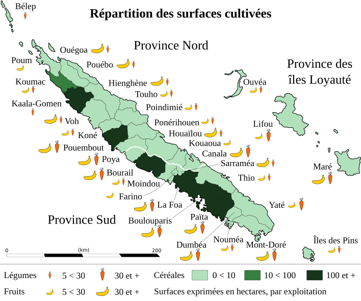
Distribution of cultivated areas in New Caledonia in 2012
Summary
[edit]| Description |
Français : Répartition des surfaces affectées aux cultures par commune de Nouvelle-Calédonie en 2012. |
||
| Date | |||
| Source |
English: * Background map: Comunas y provincias de Nueva Caledonia.svg by Dvtrano
Français : * Fond de carte : Comunas y provincias de Nueva Caledonia.svg par Dvtrano
|
||
| Author | |||
| Attribution (required by the license) | © Sémhur / Wikimedia Commons / | ||
| SVG development |
|

| Object location | | View this and other nearby images on: OpenStreetMap |
|---|
Licensing
[edit]
I, the copyright holder of this work, hereby publish it under the following licenses:
| Copyleft: This work of art is free; you can redistribute it and/or modify it according to terms of the Free Art License. You will find a specimen of this license on the Copyleft Attitude site as well as on other sites. |
This file is licensed under the Creative Commons Attribution-Share Alike Attribution-Share Alike 4.0 International, 3.0 Unported, 2.5 Generic, 2.0 Generic and 1.0 Generic license.
- You are free:
- to share – to copy, distribute and transmit the work
- to remix – to adapt the work
- Under the following conditions:
- attribution – You must give appropriate credit, provide a link to the license, and indicate if changes were made. You may do so in any reasonable manner, but not in any way that suggests the licensor endorses you or your use.
- share alike – If you remix, transform, or build upon the material, you must distribute your contributions under the same or compatible license as the original.
You may select the license of your choice.
File history
Click on a date/time to view the file as it appeared at that time.
| Date/Time | Thumbnail | Dimensions | User | Comment | |
|---|---|---|---|---|---|
| current | 16:35, 29 December 2022 | | 708 × 591 (181 KB) | Sémhur (talk | contribs) | == {{int:filedesc}} == {{Information |Description= {{en|1= Share of {{w|Agricultural land|land used for agriculture|en}} per commune in {{w|New Caledonia|New Caledonia|en}} in 2012.}} {{fr|1= Répartition des {{w|Surface agricole utilisée|surfaces affectées aux cultures|fr}} par commune de {{w|Nouvelle-Calédonie|Nouvelle-Calédonie|fr}} en 2012.}} |Source= {{en|1= * Background map: {{f|Comunas y provincias de Nueva Caledonia.svg}} by {{u|Dvtrano}} * Data:[https://davar.gouv.nc/sites/default/fil... |
You cannot overwrite this file.
File usage on Commons
There are no pages that use this file.
File usage on other wikis
The following other wikis use this file:
- Usage on fr.wikipedia.org