File:New-York - by David H. Burr; engraved and printed by S. Stiles and Co., N. York. NYPL434740.tiff
Jump to navigation
Jump to search

Size of this JPG preview of this TIF file: 670 × 599 pixels. Other resolutions: 268 × 240 pixels | 537 × 480 pixels | 859 × 768 pixels | 1,145 × 1,024 pixels | 2,290 × 2,048 pixels | 5,133 × 4,590 pixels.
Original file (5,133 × 4,590 pixels, file size: 67.41 MB, MIME type: image/tiff)
Captions
Captions
Add a one-line explanation of what this file represents
Summary
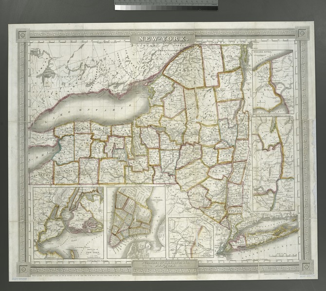
[edit]| Description | New-York / by David H. Burr ; engraved and printed by S. Stiles and Co., N. York.; Maps of New York City and State / Whole | |||||||||||||||||||||||
| Notes | "Entered according to act of Congress in the year 1833 by J.H. Colton and Co. in the Clerks Office of the District Court of the Southern District of New York." ''Note 2.'') From the author's Atlas of the state of New York. ''Note 3.'') Insets: Environs of New York -- City of New York -- Environs of Utica -- From Albany to Lake Champlain and L. George -- Niagara River. ''Note 4.'') National Endowment for the Humanities Grant for Access to Early Maps of the Middle Atlantic Seaboard. ''Note 5.'') Prime meridians: Greenwich and Washington. ''Note 6.'') Shows wards and county boundaries. | |||||||||||||||||||||||
| Item physical description | 1 map : hand col. ; 43 x 53 cm. | |||||||||||||||||||||||
| Catalogue call number | Map Div. 01-1866 | |||||||||||||||||||||||
| Standard reference | NYPL. Dictionary catalog of the Map Division, VII, p. 159; Phillips. Maps of America, p. 511 | |||||||||||||||||||||||
| Date | ||||||||||||||||||||||||
| Source |
http://digitalgallery.nypl.org/nypldigital/dgkeysearchdetail.cfm?imageID=434740
|
|||||||||||||||||||||||
| Author | David H., 1803-1875 -- Cartographer Burr | |||||||||||||||||||||||
| Permission (Reusing this file) |
From The Lionel Pincus and Princess Firyal Map Division. http://maps.nypl.org
|
|||||||||||||||||||||||
| Location | Stephen A. Schwarzman Building / The Lionel Pincus and Princess Firyal Map Division | |||||||||||||||||||||||
| Digital item published | 2-3-2004; updated 3-25-2011 | |||||||||||||||||||||||
| Digital ID | 434740 | |||||||||||||||||||||||

The making of this file was supported by Wikimedia UK.
To see other files made with the support of Wikimedia UK, please see the category Supported by Wikimedia UK.
|
File history
Click on a date/time to view the file as it appeared at that time.
| Date/Time | Thumbnail | Dimensions | User | Comment | |
|---|---|---|---|---|---|
| current | 10:33, 2 May 2014 |  | 5,133 × 4,590 (67.41 MB) | Fæ (talk | contribs) | GWToolset:: Creating mediafile for Fæ. Tranche 3 11591-16518 @ 2 May, 06:47 BST |
You cannot overwrite this file.
File usage on Commons
There are no pages that use this file.