File:Mercer Co., N.J. - N4007.5-W7428.5-18.5 x 29 - 1981 LOC 85695372.jpg
Jump to navigation
Jump to search

Size of this preview: 631 × 599 pixels. Other resolutions: 253 × 240 pixels | 506 × 480 pixels | 809 × 768 pixels | 1,078 × 1,024 pixels | 2,157 × 2,048 pixels | 5,268 × 5,002 pixels.
Original file (5,268 × 5,002 pixels, file size: 3.07 MB, MIME type: image/jpeg)
Captions
Captions
Add a one-line explanation of what this file represents
Summary
[edit]| Description |
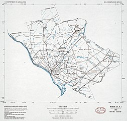
English: "May 1985." UTM grid. Includes notes. "4-R-39120." Available also through the Library of Congress Web site as a raster image. |
||
| Title | Mercer Co., N.J. : N4007.5-W7428.5/18.5 x 29 : 1981 | ||
| Shelf ID | G3813.M4 1981 .U5 | ||
| Date | |||
| Source | https://www.loc.gov/item/85695372/ | ||
| Author | United States. Soil Conservation Service; Geological Survey (U.S.) | ||
| Permission (Reusing this file) |
|
||
| Other versions |
|
||
| Location | New Jersey · United States · Mercer County | ||
| Part of | American Memory · General Maps · Catalog · Geography And Map Division | ||
| Subject | United States · Mercer County (N.J.) · New Jersey · Mercer County · Maps |


Licensing
[edit]
| This work is from the Library of Congress. According to the library, there are no known copyright restrictions on the use of this work. |  |
File history
Click on a date/time to view the file as it appeared at that time.
| Date/Time | Thumbnail | Dimensions | User | Comment | |
|---|---|---|---|---|---|
| current | 05:50, 20 May 2018 | | 5,268 × 5,002 (3.07 MB) | Fæ (talk | contribs) | LOC Maps https://www.loc.gov/item/85695372/ #12088 |
You cannot overwrite this file.
File usage on Commons
The following page uses this file: