File:Mariaeburgum 0414.028.005 Front.tif
Jump to navigation
Jump to search

Size of this JPG preview of this TIF file: 800 × 581 pixels. Other resolutions: 320 × 232 pixels | 640 × 464 pixels | 1,024 × 743 pixels | 1,280 × 929 pixels | 2,560 × 1,858 pixels | 10,100 × 7,329 pixels.
Original file (10,100 × 7,329 pixels, file size: 141.47 MB, MIME type: image/tiff)
Captions
Captions
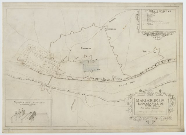
Map of the Malbork Castle
Summary
[edit]| Description |
English: Hand drawn map of the Malbork Castle and its immediate surroundings
Svenska: Handritad karta över borgen i Malbork och dess närmaste omgivning |
|||||||||||||||||||||||||||||
| Date | ||||||||||||||||||||||||||||||
| Source |
https://sok.riksarkivet.se/arkiv/UZ0lMHu0oqYpzmRvp3wna1
|
|||||||||||||||||||||||||||||
| Creator |
Friedrich Getkant |
|||||||||||||||||||||||||||||
| Geotemporal data | ||||||||||||||||||||||||||||||
| Bounding box |
|
|||||||||||||||||||||||||||||
| Georeferencing | ||||||||||||||||||||||||||||||


Licensing
[edit]|
This work is in the public domain in its country of origin and other countries and areas where the copyright term is the author's life plus 70 years or fewer. | |
| This file has been identified as being free of known restrictions under copyright law, including all related and neighboring rights. | |
This work is in the public domain in the United States because it meets three requirements:
For background information, see the explanations on Non-U.S. copyrights.
Note: This tag should not be used for sound recordings. |
File history
Click on a date/time to view the file as it appeared at that time.
| Date/Time | Thumbnail | Dimensions | User | Comment | |
|---|---|---|---|---|---|
| current | 11:57, 9 November 2021 |  | 10,100 × 7,329 (141.47 MB) | Nils Weinander (Riksarkivet Sverige) (talk | contribs) | c:User:Rillke/bigChunkedUpload.js: Cleared incorrect EXIF data |
| 11:39, 28 October 2021 |  | 10,100 × 7,329 (211.8 MB) | Nils Weinander (Riksarkivet Sverige) (talk | contribs) | Uploaded a work by Friedrich Getkant from https://sok.riksarkivet.se/arkiv/UZ0lMHu0oqYpzmRvp3wna1 with UploadWizard |
You cannot overwrite this file.
File usage on Commons
The following page uses this file:
File usage on other wikis
The following other wikis use this file:
- Usage on outreach.wikimedia.org
- Usage on sv.wikipedia.org
- Usage on www.wikidata.org