File:Map of Texas and Part of New Mexico 1857 (1887) UTA.jpg
Jump to navigation
Jump to search
Size of this preview: 800 × 502 pixels. Other resolutions: 320 × 201 pixels | 640 × 402 pixels | 1,024 × 643 pixels | 1,280 × 804 pixels | 2,560 × 1,608 pixels | 4,188 × 2,630 pixels.
Original file (4,188 × 2,630 pixels, file size: 1.54 MB, MIME type: image/jpeg)
Captions
Captions
Add a one-line explanation of what this file represents
Summary
[edit]_UTA.jpg&action=edit§ion=1)
| Title |
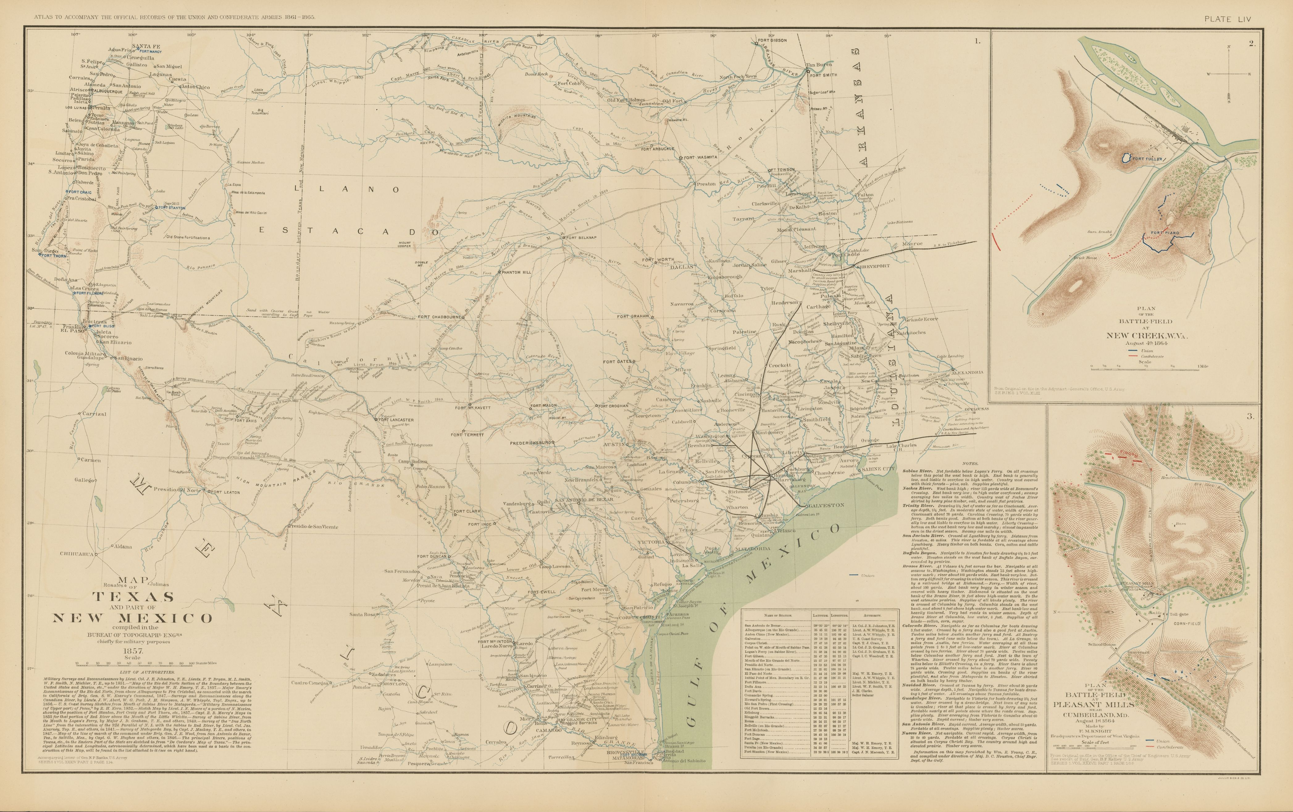
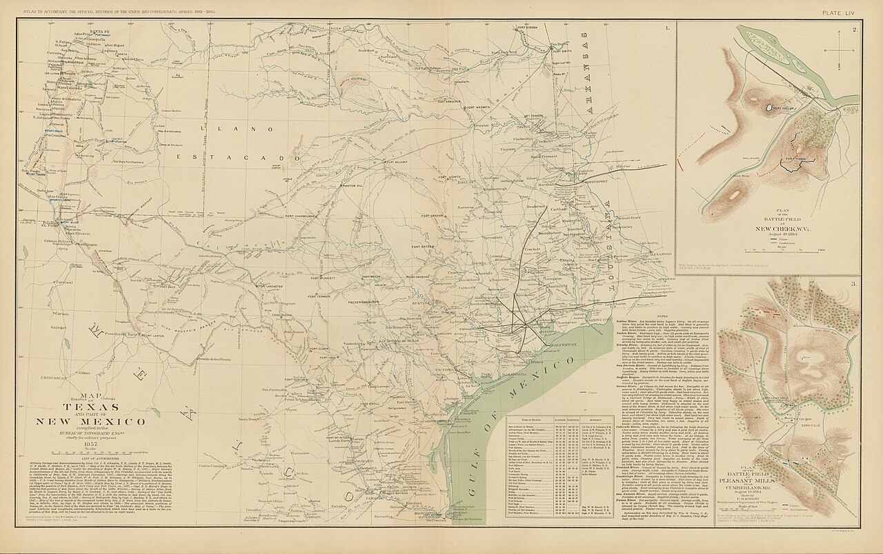
English: Map of Texas and Part of New Mexico, 1857, compiled in the Bureau of Topographical Engineers, chiefly for Military Purposes |
||||||||||||||||||||||||||
| Description |
English: Although not published until 1891-1895, this map of Texas and New Mexico was based upon information compiled by the U.S. Army Corps of Topographical Engineers by 1857. From 1862 in manuscript form, Union General N. P. Banks, commander of the Union Department of the Gulf, utilized it for planning and military operations. Not surprisingly, there is a wealth of militarily important information here: forts and military camp locations, river crossings, and navigation notes, local crops, and water. Exploration, survey routes, and travel problems are identified along with two inset battleplans. |
||||||||||||||||||||||||||
| Date | |||||||||||||||||||||||||||
| Source | UTA Libraries Cartographic Connections: map / text | ||||||||||||||||||||||||||
| Creator |
Unknown author |
||||||||||||||||||||||||||
| Credit line |
English: The University of Texas at Arlington Libraries Special Collections |
||||||||||||||||||||||||||
| Geotemporal data | |||||||||||||||||||||||||||
| Map location |
Texas New Mexico |
||||||||||||||||||||||||||
| Georeferencing | If inappropriate please set warp_status = skip to hide. | ||||||||||||||||||||||||||
| Bibliographic data | |||||||||||||||||||||||||||
| Page(s) | 148-149 | ||||||||||||||||||||||||||
| Place of publication | Washington, D.C. | ||||||||||||||||||||||||||
| Publisher |
Julius Bien & Co. |
||||||||||||||||||||||||||
| Archival data | |||||||||||||||||||||||||||
| Collection |
|
||||||||||||||||||||||||||
| Dimensions | height: 42 cm (16.5 in); width: 57 cm (22.4 in) | ||||||||||||||||||||||||||
| Medium | chromolithograph | ||||||||||||||||||||||||||
| artwork-references | Martin and Martin Maps of Texas, p. 152 | ||||||||||||||||||||||||||
Licensing
[edit]_UTA.jpg&action=edit§ion=2)

|
This file was provided to Wikimedia Commons by the University of Texas at Arlington Libraries as part of a cooperation project. The University of Texas at Arlington Libraries is part of the University of Texas at Arlington, a public research university located in Arlington, Texas.
|
This work was published before January 1, 1929 and it is anonymous or pseudonymous due to unknown authorship. It is in the public domain in the United States as well as countries and areas where the copyright terms of anonymous or pseudonymous works are 95 years or fewer since publication.
|
File history
Click on a date/time to view the file as it appeared at that time.
| Date/Time | Thumbnail | Dimensions | User | Comment | |
|---|---|---|---|---|---|
| current | 14:36, 22 April 2022 | | 4,188 × 2,630 (1.54 MB) | Michael Barera (talk | contribs) | == {{int:filedesc}} == {{Map |title = {{en|'''''Map of Texas and Part of New Mexico, 1857, compiled in the Bureau of Topographical Engineers, chiefly for Military Purposes'''''}} |description = {{en|Although not published until 1891-1895, this map of Texas and New Mexico was based upon information compiled by the U.S. Army Corps of Topographical Engineers by 1857. From 1862 in manuscript form, Union General N. P. Banks, commander of the Union Department of the Gulf, utiliz... |
You cannot overwrite this file.
File usage on Commons
The following page uses this file:
_UTA.jpg&oldid=798784190)