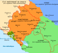
File:Map of Montenegro World War Two-fr.svg
From Wikimedia Commons, the free media repository
Jump to navigation
Jump to search

Size of this PNG preview of this SVG file: 648 × 600 pixels. Other resolutions: 259 × 240 pixels | 519 × 480 pixels | 830 × 768 pixels | 1,107 × 1,024 pixels | 2,214 × 2,048 pixels | 1,791 × 1,657 pixels.
Original file (SVG file, nominally 1,791 × 1,657 pixels, file size: 70 KB)
File information
Structured data
Captions
Captions
Add a one-line explanation of what this file represents
Summary
[edit]| DescriptionMap of Montenegro World War Two-fr.svg |
Français : Carte du Monténégro pendant la Seconde Guerre mondiale, avec la présence des frontières de l'entre deux-guerres.
|
| Date | |
| Source | File:MontenegroDuranteLaSegundaGuerraMundial.svg Pakko |
| Author |
|
| Other versions |
|
This map was improved or created by the Wikigraphists of the Graphic Lab (fr). You can propose images to clean up, improve, create or translate as well. |
Licensing
[edit]I, the copyright holder of this work, hereby publish it under the following licenses:
| This file is licensed under the Creative Commons Attribution-Share Alike 3.0 Unported license. | ||
| ||
| This licensing tag was added to this file as part of the GFDL licensing update.http://creativecommons.org/licenses/by-sa/3.0/CC BY-SA 3.0Creative Commons Attribution-Share Alike 3.0truetrue |

|
Permission is granted to copy, distribute and/or modify this document under the terms of the GNU Free Documentation License, Version 1.2 or any later version published by the Free Software Foundation; with no Invariant Sections, no Front-Cover Texts, and no Back-Cover Texts. A copy of the license is included in the section entitled GNU Free Documentation License.http://www.gnu.org/copyleft/fdl.htmlGFDLGNU Free Documentation Licensetruetrue |
You may select the license of your choice.
File history
Click on a date/time to view the file as it appeared at that time.
| Date/Time | Thumbnail | Dimensions | User | Comment | |
|---|---|---|---|---|---|
| current | 13:55, 17 June 2022 |  | 1,791 × 1,657 (70 KB) | Augusta 89 (talk | contribs) | Suppression d'une frontière |
| 13:50, 12 June 2022 |  | 1,791 × 1,657 (70 KB) | Augusta 89 (talk | contribs) | Correction du territoire des Bouches du Kotor | |
| 13:19, 29 September 2019 |  | 1,791 × 1,657 (69 KB) | Augusta 89 (talk | contribs) | Correction de la frontière de Kotor | |
| 10:04, 20 July 2015 |  | 1,791 × 1,657 (75 KB) | Augusta 89 (talk | contribs) | User created page with UploadWizard |
You cannot overwrite this file.
File usage on Commons
The following 7 pages use this file:
- User:Geagea/Israel/2015 July 20
- User:J budissin/Uploads/BiH/2019 September 21-30
- User:Magog the Ogre/Maps of conflicts/2015 July
- User:Magog the Ogre/Maps of conflicts/2019 September
- User:Magog the Ogre/Maps of conflicts/2022 June
- User:Magog the Ogre/Multilingual legend/2022 June 11-20
- File:MontenegroDuranteLaSegundaGuerraMundial.svg
File usage on other wikis
The following other wikis use this file:
- Usage on ca.wikipedia.org
- Usage on fr.wikipedia.org
Metadata
This file contains additional information such as Exif metadata which may have been added by the digital camera, scanner, or software program used to create or digitize it. If the file has been modified from its original state, some details such as the timestamp may not fully reflect those of the original file. The timestamp is only as accurate as the clock in the camera, and it may be completely wrong.
| Width | 1791.2122 |
|---|---|
| Height | 1657.2126 |
