File:Map - Special Collections University of Amsterdam - OTM- HB-KZL 31-02-46.tif
Jump to navigation
Jump to search

Size of this JPG preview of this TIF file: 692 × 600 pixels. Other resolutions: 277 × 240 pixels | 554 × 480 pixels | 886 × 768 pixels | 1,182 × 1,024 pixels | 2,363 × 2,048 pixels | 7,653 × 6,633 pixels.
Original file (7,653 × 6,633 pixels, file size: 145.23 MB, MIME type: image/tiff)
Captions
Captions
Add a one-line explanation of what this file represents
Summary
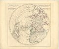
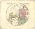
[edit]| L’hemisphere septentrional pour voir plus distinctement les terres arctiques / par Guillaume Delisle de lAcademie Rle. des Sciences ; rectifier selon la carte de monsieur Jean Kyrilow ... = verbetert na de kaart van den heer Johannes Kyrilow ...
( |
|||||||||||||||||||||||||||
|---|---|---|---|---|---|---|---|---|---|---|---|---|---|---|---|---|---|---|---|---|---|---|---|---|---|---|---|
| Author |
|
||||||||||||||||||||||||||
| Title |
L’hemisphere septentrional pour voir plus distinctement les terres arctiques / par Guillaume Delisle de lAcademie Rle. des Sciences ; rectifier selon la carte de monsieur Jean Kyrilow ... = verbetert na de kaart van den heer Johannes Kyrilow ... |
||||||||||||||||||||||||||
| Date | circa 1745 | ||||||||||||||||||||||||||
| Medium | Copperplate print | ||||||||||||||||||||||||||
| Dimensions | height: 45.5 cm (17.9 in); width: 51 cm (20 in) | ||||||||||||||||||||||||||
| Collection |
|
||||||||||||||||||||||||||
| Accession number |
OTM: HB-KZL 31-02-46 |
||||||||||||||||||||||||||
| Place of creation | Amsterdam, published and printed by Johannes Covens (1720-1772) and Cornelis Mortier (1720-1772) | ||||||||||||||||||||||||||
| Notes | This object is part of the collection of the Koninklijk Nederlands Aardrijkskundig Genootschap (KNAG) | ||||||||||||||||||||||||||
| Source/Photographer |
|
||||||||||||||||||||||||||
| Permission (Reusing this file) |
|
||||||||||||||||||||||||||
| Other versions |
|
||||||||||||||||||||||||||


File history
Click on a date/time to view the file as it appeared at that time.
| Date/Time | Thumbnail | Dimensions | User | Comment | |
|---|---|---|---|---|---|
| current | 11:08, 20 March 2018 |  | 7,653 × 6,633 (145.23 MB) | DeJong2332 (talk | contribs) | pattypan 18.02 |
You cannot overwrite this file.
File usage on Commons
The following 6 pages use this file:
- File:Map - Special Collections University of Amsterdam - OTM- HB-KZL 31-02-43.tif
- File:Map - Special Collections University of Amsterdam - OTM- HB-KZL 31-02-44.tif
- File:Map - Special Collections University of Amsterdam - OTM- HB-KZL 31-02-45.tif
- File:Map - Special Collections University of Amsterdam - OTM- HB-KZL 31-02-46.tif
- File:Map - Special Collections University of Amsterdam - OTM- HB-KZL 31-02-47.tif
- File:Map - Special Collections University of Amsterdam - OTM- HB-KZL 31-02-48.tif
File usage on other wikis
The following other wikis use this file:
- Usage on lt.wikipedia.org