File:Map-Deutsch-Afrika.png

Original file (2,294 × 1,456 pixels, file size: 2.06 MB, MIME type: image/png)
Captions
Captions
| Description |
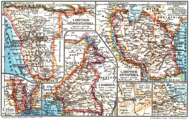
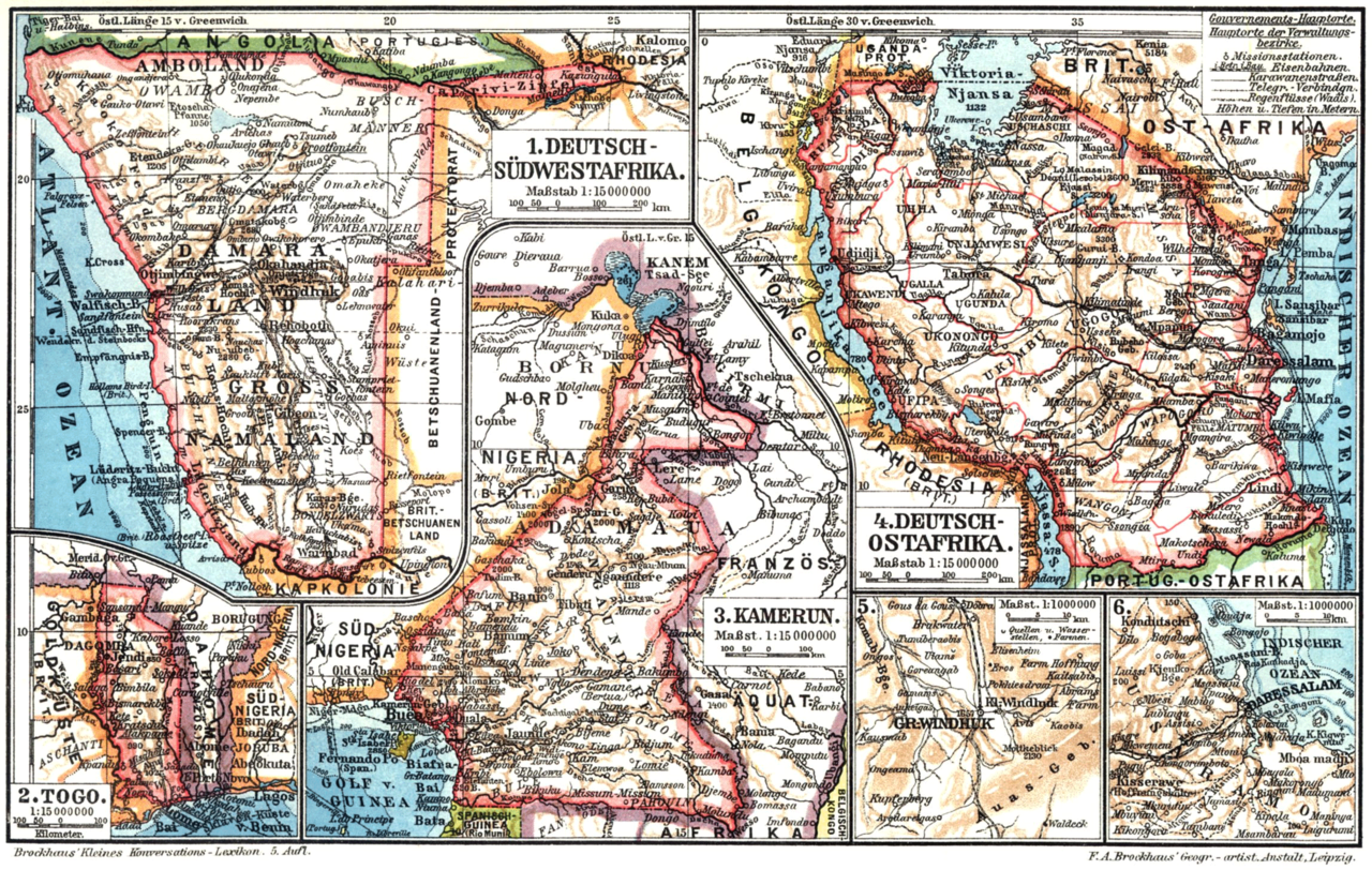
Deutsch: 1. Deutsch-Südwestafrika. 2. Togo. 3. Kamerun. 4. Deutsch-Ostafrika. |
| Date | before 1911 |
| Source | Brockhaus Kleines Konversations-Lexikon (5. Auflage 1911) zeno.org |
| Author | F. A. Brockhaus' Geogr.- artist.Anstalt, Leipzig/F. A. Brockhaus |
| Permission (Reusing this file) |
Deutsch: Dieses Werk ist nach unserer Meinung frei von Rechten Dritter. Vor einer weiteren Verwertung ist unbedingt zu überprüfen, ob diese Auffassung haltbar ist, da Zenodot jegliche Haftung ablehnt und ausdrücklich nicht von möglichen Ansprüchen Dritter freistellt. Für den Fall einer Bestätigung unserer Auffassung gilt:
Dieser Inhalt darf als Einzelwerk oder Werkbestandteil - auch zu kommerziellen und gewerblichen Zwecken - kopiert, verbreitet, öffentlich wiedergegeben und Dritten zugänglich gemacht werden. Wir bitten darum, auf die Herkunft des Inhaltes wie folgt hinzuweisen: Quelle: http://www.zeno.org - Zenodot Verlagsgesellschaft mbH Copyright-Vermerke, Marken oder andere Rechtsvorbehalte Dritter dürfen nicht entfernt werden.English: According to our opinion, this work is free of third party rights. Before any further utilisation, it is imperative to examine whether this assessment can be maintained, as Zenodot refuses any liability and does expressly not indemnify from potential claims by third parties. In case of a confirmation of our assessment, the following shall apply:
These contents may be copied, disseminated, publicly reproduced and be made available to third parties, as an individual work or as part of a work - also for business or commercial purposes. We ask you to refer to the origin of such contents as follows: Source: http://www.zeno.org - Zenodot Verlagsgesellschaft mbH Copyright notes, trademarks or other reservations of rights by third parties may not be deleted. |
|
This work is in the public domain in its country of origin and other countries and areas where the copyright term is the author's life plus 70 years or fewer.
| |
| This file has been identified as being free of known restrictions under copyright law, including all related and neighboring rights. | |
File history
Click on a date/time to view the file as it appeared at that time.
| Date/Time | Thumbnail | Dimensions | User | Comment | |
|---|---|---|---|---|---|
| current | 22:00, 2 December 2007 | | 2,294 × 1,456 (2.06 MB) | LSDSL (talk | contribs) | http://www.zeno.org/Brockhaus-1911.images/I/bkklde31.jpg |
| 22:37, 1 December 2007 |  | 1,166 × 738 (663 KB) | LSDSL (talk | contribs) | {{Information |Description={{de|1. Deutsch-Südwestafrika. 2. Togo. 3. Kamerun. 4. Deutsch-Ostafrika.}} |Source=Brockhaus 1906 |Date=<1906 |Author=F. A. Brockhaus |Permission= |other_versions= }} Category:Maps showing the history of German colonies |
You cannot overwrite this file.
File usage on Commons
There are no pages that use this file.