File:Louresvallesmola.jpg
Jump to navigation
Jump to search

Size of this preview: 800 × 450 pixels. Other resolutions: 320 × 180 pixels | 640 × 360 pixels | 1,024 × 576 pixels | 1,280 × 720 pixels | 1,920 × 1,080 pixels.
Original file (1,920 × 1,080 pixels, file size: 767 KB, MIME type: image/jpeg)
Captions
Captions
Add a one-line explanation of what this file represents


Summary
[edit]
| Description |
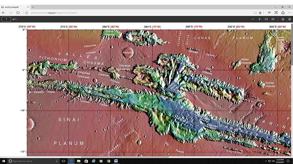
English: MOLA map showing location of Loures Valles and surrounding features. Features are labeled. |
| Date | |
| Source | http://planetarynames.wr.usgs.gov/images/mc18_mola.pdf |
| Author | Jim Secosky modified NASA image. NASA/USGS |
Licensing
[edit]
| This file is in the public domain in the United States because it was solely created by NASA. NASA copyright policy states that "NASA material is not protected by copyright unless noted". (See Template:PD-USGov, NASA copyright policy page or JPL Image Use Policy.) | ||
 |
Warnings:
|
File history
Click on a date/time to view the file as it appeared at that time.
| Date/Time | Thumbnail | Dimensions | User | Comment | |
|---|---|---|---|---|---|
| current | 18:52, 23 May 2017 | | 1,920 × 1,080 (767 KB) | Jimmarsmars (talk | contribs) | {{Information |Description ={{en|1=MOLA map showing location of Loures Valles and surrounding features. Features are labeled.}} |Source =http://planetarynames.wr.usgs.gov/images/mc18_mola.pdf |Author =Jim Secosky modified NASA image... |
You cannot overwrite this file.
File usage on Commons
There are no pages that use this file.
File usage on other wikis
The following other wikis use this file:
- Usage on ca.wikipedia.org
- Usage on en.wikipedia.org
- Usage on zh.wikipedia.org
Categories:
- Valleys and canyons on Mars
- Mars topography
- Maps of Coprates quadrangle
- Maps of Valles Marineris
- Louros Valles
- Melas Chasma
- Candor Chasma
- Ophir Chasma
- Coprates Chasma
- Ius Chasma
- Hydrae Chasma
- Baetis Chasma
- Ceti Chasma
- Juventae Chasma
- Echus Chasma
- Dittaino Valles
- Valles Marineris
- Juventae Dorsa
- Ganges Catena
- Calydon Fossa
- Tithoniae Fossae
- Tithoniae Catenae
- Coprates quadrangle
- Candor Labes
- Ceti Labes
- Coprates Labes
- Ius Labes
- Melas Labes
- Ophir Labes
- Nia Tholus
- Perrotin (Martian crater)
- Baetis Chaos