File:Location map of the Pays de la Loire region, France.svg
Jump to navigation
Jump to search

Size of this PNG preview of this SVG file: 619 × 599 pixels. Other resolutions: 248 × 240 pixels | 496 × 480 pixels | 793 × 768 pixels | 1,058 × 1,024 pixels | 2,115 × 2,048 pixels | 1,546 × 1,497 pixels.
Original file (SVG file, nominally 1,546 × 1,497 pixels, file size: 906 KB)
Captions
Captions
Add a one-line explanation of what this file represents
Summary
[edit]
| Description |
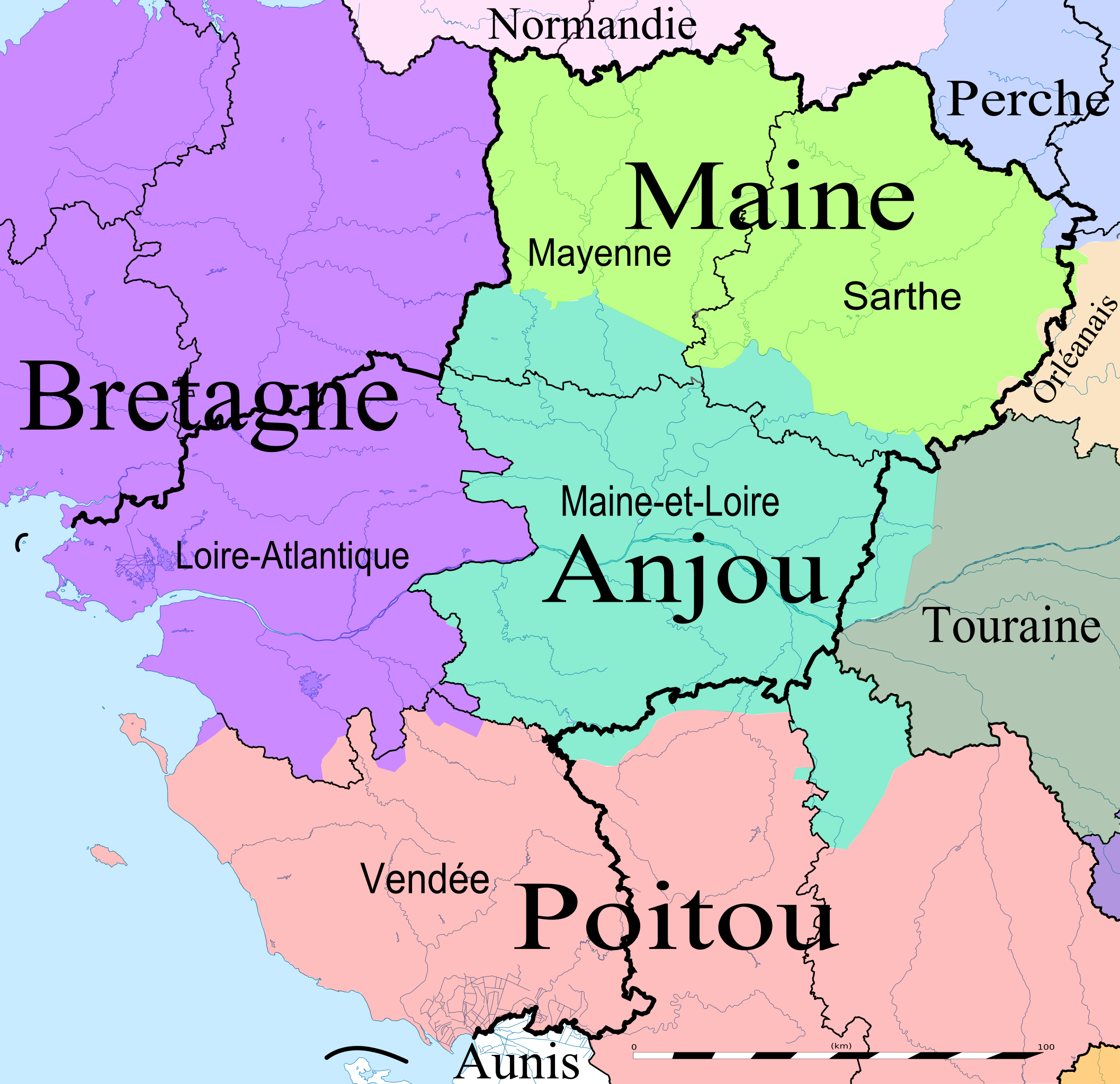
Brezhoneg: Kartenn rannvro velestradurel Broioù-al-Liger hag ar proviñsoù kozh a ya d'hec'h ober. English: Map of the Pays de la Loire region, France, with the former provinces. Français : Carte des Pays de la Loire avec les anciennes provinces. |
| Date | |
| Source | Eric Gaba (Sting - fr:Sting) (Media:Pays de la Loire region location map.svg) |
| Author | Oie blanche |
Licensing
[edit]
I, the copyright holder of this work, hereby publish it under the following license:
This file is licensed under the Creative Commons Attribution-Share Alike 3.0 Unported license.
- You are free:
- to share – to copy, distribute and transmit the work
- to remix – to adapt the work
- Under the following conditions:
- attribution – You must give appropriate credit, provide a link to the license, and indicate if changes were made. You may do so in any reasonable manner, but not in any way that suggests the licensor endorses you or your use.
- share alike – If you remix, transform, or build upon the material, you must distribute your contributions under the same or compatible license as the original.
File history
Click on a date/time to view the file as it appeared at that time.
| Date/Time | Thumbnail | Dimensions | User | Comment | |
|---|---|---|---|---|---|
| current | 11:34, 3 May 2013 | | 1,546 × 1,497 (906 KB) | Oie blanche (talk | contribs) | Reverted to version as of 21:51, 2 May 2013 |
| 21:52, 2 May 2013 |  | 1,546 × 1,497 (906 KB) | Oie blanche (talk | contribs) | Minor edits. | |
| 21:51, 2 May 2013 |  | 1,546 × 1,497 (906 KB) | Oie blanche (talk | contribs) | Minor edits | |
| 08:25, 11 April 2013 |  | 1,546 × 1,497 (899 KB) | Oie blanche (talk | contribs) | + Surrounding provinces. | |
| 07:47, 11 April 2013 |  | 1,546 × 1,497 (841 KB) | Oie blanche (talk | contribs) | User created page with UploadWizard |
You cannot overwrite this file.
File usage on Commons
There are no pages that use this file.
File usage on other wikis
The following other wikis use this file:
- Usage on br.wikipedia.org
- Usage on en.wikipedia.org
- Usage on es.wikipedia.org
- Usage on fr.wikipedia.org
- Usage on fr.wiktionary.org
- Usage on he.wikipedia.org
- Usage on it.wikipedia.org
- Usage on la.wikipedia.org
- Usage on pt.wikipedia.org