File:Livland 1260.png
Jump to navigation
Jump to search

Size of this preview: 553 × 599 pixels. Other resolutions: 222 × 240 pixels | 443 × 480 pixels | 709 × 768 pixels | 945 × 1,024 pixels | 1,909 × 2,068 pixels.
Original file (1,909 × 2,068 pixels, file size: 576 KB, MIME type: image/png)
Captions
Captions
Add a one-line explanation of what this file represents
Summary
[edit]| Description |
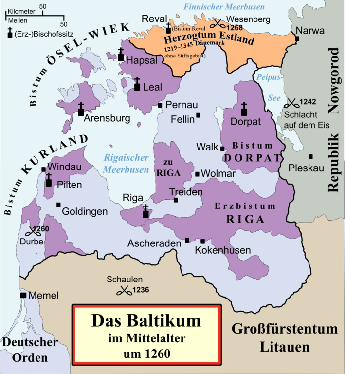
Deutsch: Politische Karte von Livland im Mittelalter, etwa 1260.
Besitz des Schwertbrüderordens bzw. Deutschen Ordens (in Preußen) Geistlicher Besitz English: Political map of the Medieval Livonia, circa 1260, along with surrounding areas:
Possessions of the Sword Brothers (in Livonia) and the Teutonic Order (in Prussia) Ecclesiastical possessions |
||||||||
| Date | |||||||||
| Source |
Own work, using
|
||||||||
| Author | Originally created by MapMaster, commissioned by Attilios, translated by NordNordWest, modified by Furfur | ||||||||
| Permission (Reusing this file) |
I, the copyright holder of this work, hereby publish it under the following license:
|
||||||||
| Other versions |
|
||||||||
| PNG development |

File history
Click on a date/time to view the file as it appeared at that time.
| Date/Time | Thumbnail | Dimensions | User | Comment | |
|---|---|---|---|---|---|
| current | 00:25, 11 July 2024 | | 1,909 × 2,068 (576 KB) | Ulamm (talk | contribs) | {{Information |description= {{de|Politische Karte von Livland im Mittelalter, etwa 1260. {{legtab|#D7DFF3|Besitz des Schwertbrüderordens bzw. Deutschen Ordens (in Preußen) |#BF8DC6|Geistlicher Besitz}} }} {{en|Political map of the Medieval Livonia, circa 1260, along with surrounding areas: {{legtab|#D7DFF3|Possessions of the Sword Brothers (in Livonia) and the Teutonic Order (in Prussia) |#BF8DC6|Ecclesiastical possessions}}}} |source={{Own}}, using * {{cite book|first=Stephen|last=Turnbull|p... |
You cannot overwrite this file.
File usage on Commons
The following page uses this file:
File usage on other wikis
The following other wikis use this file:
- Usage on af.wikipedia.org
- Usage on de.wikipedia.org
- 1242
- 1260
- Lettland
- Estland
- Baltikum
- Liven
- Livland
- Deutsch-Balten
- Schwertbrüderorden
- Schlacht auf dem Peipussee
- Liste der Erzbischöfe von Riga
- Bistum Kurland
- Bistum Ösel-Wiek
- Schlacht an der Durbe
- Schlacht von Schaulen (1236)
- Livländische Konföderation
- Litauerkriege des Deutschen Ordens
- Landmeister in Livland
- Schlacht bei Wesenberg (1268)
- Schlacht von Aizkraukle
- Liste der Backsteinbauwerke der Gotik in Estland und Lettland
- Usage on en.wikipedia.org
- Usage on eo.wikipedia.org
- Usage on et.wikipedia.org
- Usage on frr.wikipedia.org
- Usage on fr.wikipedia.org
- Usage on kk.wikipedia.org
- Usage on lv.wikipedia.org
- Usage on ro.wikipedia.org
- Usage on sl.wikipedia.org