Category:Maps of the Livonian Confederation
Jump to navigation
Jump to search
Media in category "Maps of the Livonian Confederation"
The following 40 files are in this category, out of 40 total.
-
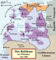
 Livonia in 1534 (English).png 475 × 486; 65 KB
-
 Vana-Liivimaa-es.svg 864 × 900; 2.55 MB
-
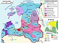
 Baltic states in the first half of the 16th century - es.svg 1,256 × 1,745; 893 KB
-
 Baltic states in the first half of the 16th century - ru.svg 1,256 × 1,745; 948 KB
-
 Baltics-1525.png 2,281 × 2,153; 114 KB
-
 Carte croisades baltes.png 802 × 603; 78 KB
-
 Confederation of Livonia 1260-fr.svg 955 × 1,034; 1.36 MB
-
 Confederazione Livone.svg 955 × 1,034; 621 KB
-
 Inflanty 1260.svg 895 × 969; 984 KB
-
 Järva foogtkond.PNG 823 × 299; 25 KB
-
 Kura pk.PNG 479 × 490; 39 KB
-
 Lihulafoogtkond.PNG 291 × 323; 10 KB
-
 Lijfland 1260-es.svg 955 × 1,459; 1.43 MB
-
 Lijfland 1260.svg 955 × 1,459; 985 KB
-
 Livland 1260.png 1,909 × 2,068; 576 KB
-
 Livland 1260.svg 955 × 1,034; 790 KB
-
 Livland gross.jpg 945 × 685; 146 KB
-
 Maasifoogtkond.PNG 618 × 553; 26 KB
-
 Medieval Livonia 1260 hu.svg 1,273 × 1,379; 1.07 MB
-
 Medieval Livonia 1260.svg 955 × 1,034; 734 KB
-
 Narva foogtkond.PNG 823 × 299; 24 KB
-
 Ordualad 1346–1558.PNG 479 × 490; 41 KB
-
 Orduskeem.PNG 475 × 486; 95 KB
-
 Partition of the Livonian Order - es.svg 930 × 1,245; 335 KB
-
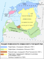 Partition of the Livonian Order - ru.svg 930 × 1,245; 390 KB
-
 Pskov Republic 1444.jpg 983 × 790; 138 KB
-
 Pärnu kkond.PNG 664 × 480; 29 KB
-
 Rakvere fk.PNG 823 × 299; 25 KB
-
 Riia ppk.PNG 479 × 490; 41 KB
-
 S-L pk Liivis.PNG 479 × 490; 38 KB
-
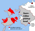
 Saare-Laane pk.PNG 808 × 624; 35 KB
-
 Tallinna kk.PNG 823 × 299; 25 KB
-
 Tallinna pk Liivis.PNG 479 × 490; 39 KB
-
 Tartu pk Liivis.PNG 479 × 490; 40 KB
-
 Tartu pk.PNG 490 × 626; 18 KB
-
 Toolse foogtkond.PNG 823 × 299; 24 KB
-
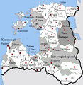
 Vana-Liivimaa (Eesti keeles).PNG 475 × 486; 69 KB
-
 Vasknarva foogtkond.PNG 823 × 299; 25 KB
-
 Viljandi komtuurkond 15 16.PNG 664 × 480; 35 KB
-
 Ливонская Конфедерация 1260.png 600 × 650; 192 KB
.png)


.PNG)

