File:Hamme teufelsmoor.png
Jump to navigation
Jump to search
Size of this preview: 526 × 600 pixels. Other resolutions: 210 × 240 pixels | 421 × 480 pixels | 776 × 885 pixels.
Original file (776 × 885 pixels, file size: 103 KB, MIME type: image/png)
Captions
Captions
Add a one-line explanation of what this file represents
| Description |
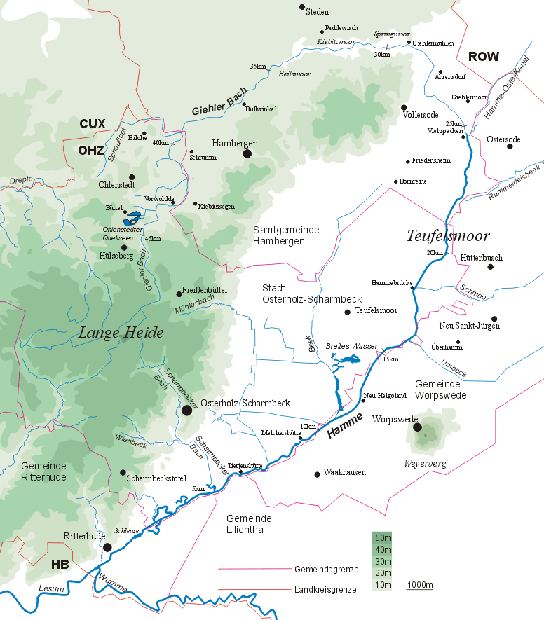
Deutsch: Flusslauf der Hamme - Höhenprofil der südlichen Wesermünder Geest im Gebiet der Langen Heide mit Quellen der Geestrandbäche. Flusslauf des Giehler Bachs bis ins Teufelsmoor und Zuflüsse der Hamme.
English: Course of the River Hamme and relief map of the southern Wesermünde Geest in the "Lange Heide" region with sources of the streams. Course of the Giehler Bach to the Teufelsmoor and tributaries of the Hamme, Lower Saxony, Germany. |
| Date | 30 May 2005 (original upload date) |
| Source |
Transferred from de.wikipedia to Commons. Selbst erstellt von CWitte ℵ1 |
| Author | CWitte at German Wikipedia |
Licensing
[edit]
CWitte at the German-language Wikipedia, the copyright holder of this work, hereby publishes it under the following license:

|
Permission is granted to copy, distribute and/or modify this document under the terms of the GNU Free Documentation License, Version 1.2 or any later version published by the Free Software Foundation; with no Invariant Sections, no Front-Cover Texts, and no Back-Cover Texts. A copy of the license is included in the section entitled GNU Free Documentation License. |
| This file is licensed under the Creative Commons Attribution-Share Alike 3.0 Unported license. | ||
| Attribution: CWitte | ||
| ||
| This licensing tag was added to this file as part of the GFDL licensing update. |
Original upload log
[edit]
The original description page was here. All following user names refer to de.wikipedia.
- 2005-05-30 14:06 CWitte 776×885× (105952 bytes)
- 2005-05-30 13:56 CWitte 762×883× (104033 bytes)
- 2005-05-30 12:13 CWitte 762×883× (103936 bytes) Flusslauf der '''Hamme''' Höhenprofil der südlichen Wesermünder Geest im Gebiet der Langen Heide mit Quellen der Geestrandbäche. Flusslauf des Giehler Bachs bis ins [[Teufelsmoor]] und Zuflüsse der Hamme.
File history
Click on a date/time to view the file as it appeared at that time.
| Date/Time | Thumbnail | Dimensions | User | Comment | |
|---|---|---|---|---|---|
| current | 07:50, 19 July 2009 | | 776 × 885 (103 KB) | Bermicourt (talk | contribs) | {{Information |Description={{de|'''Flusslauf der Hamme''' 762*883 px Höhenprofil der südlichen Wesermünder Geest im Gebiet der Langen Heide mit Quellen der Geestrandbäche. Flusslauf des Giehler Bachs bis ins de:Teufelsmoor und Zuflüsse der [[: |
You cannot overwrite this file.
File usage on Commons
The following 2 pages use this file:
File usage on other wikis
The following other wikis use this file:
- Usage on arz.wikipedia.org
- Usage on de.wikipedia.org
- Usage on en.wikipedia.org
- Usage on et.wikipedia.org
- Usage on fa.wikipedia.org
- Usage on fr.wikipedia.org
- Usage on nds.wikipedia.org
- Usage on nl.wikipedia.org
- Usage on www.wikidata.org