File:Hamburg.Karte.1813 neddermeyer 300dpi.jpg
Jump to navigation
Jump to search
Size of this preview: 755 × 600 pixels. Other resolutions: 302 × 240 pixels | 604 × 480 pixels | 967 × 768 pixels | 1,280 × 1,017 pixels | 2,560 × 2,034 pixels | 5,808 × 4,614 pixels.
Original file (5,808 × 4,614 pixels, file size: 7.63 MB, MIME type: image/jpeg)
Captions
Captions
Add a one-line explanation of what this file represents
Summary
[edit]
| Description |
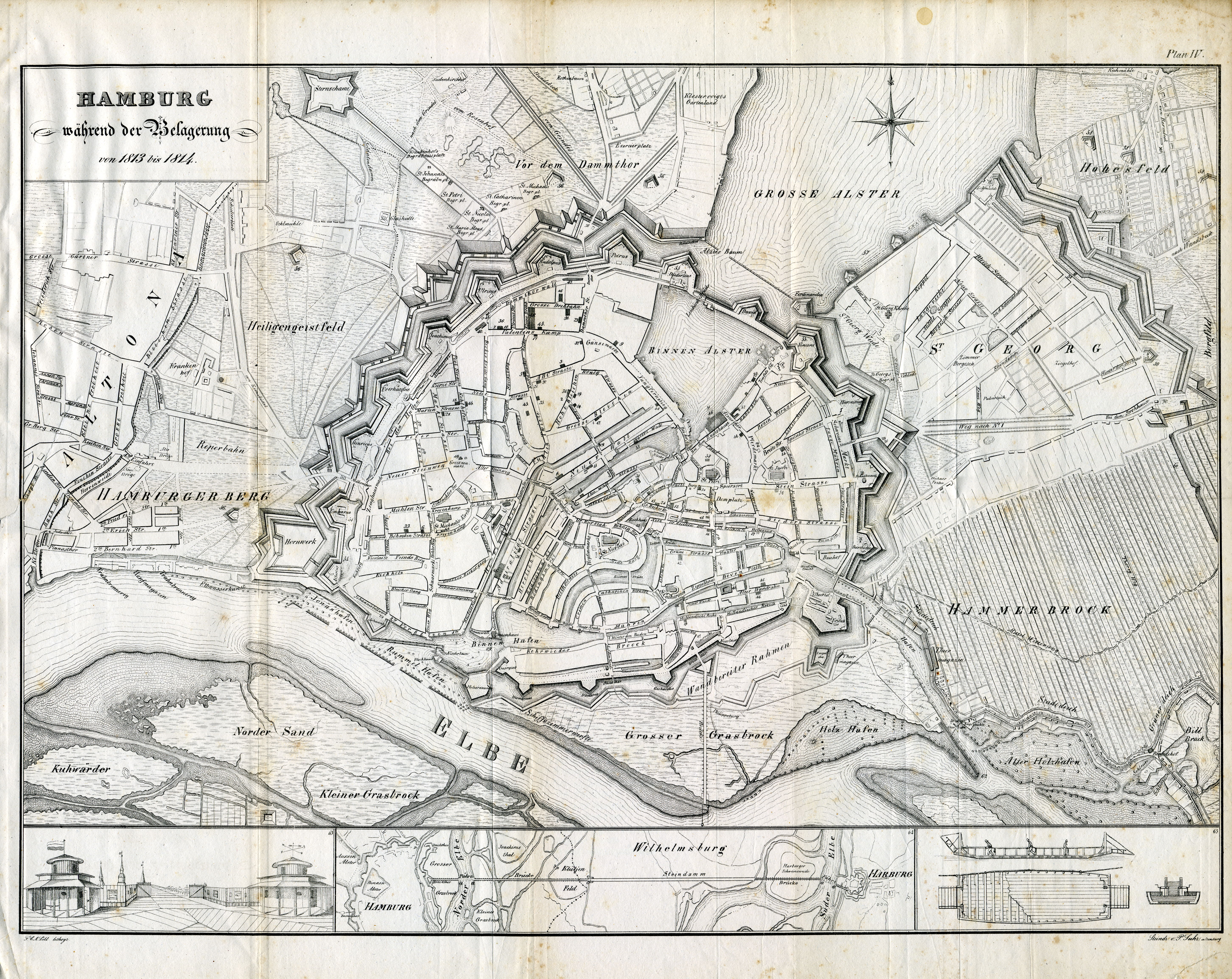
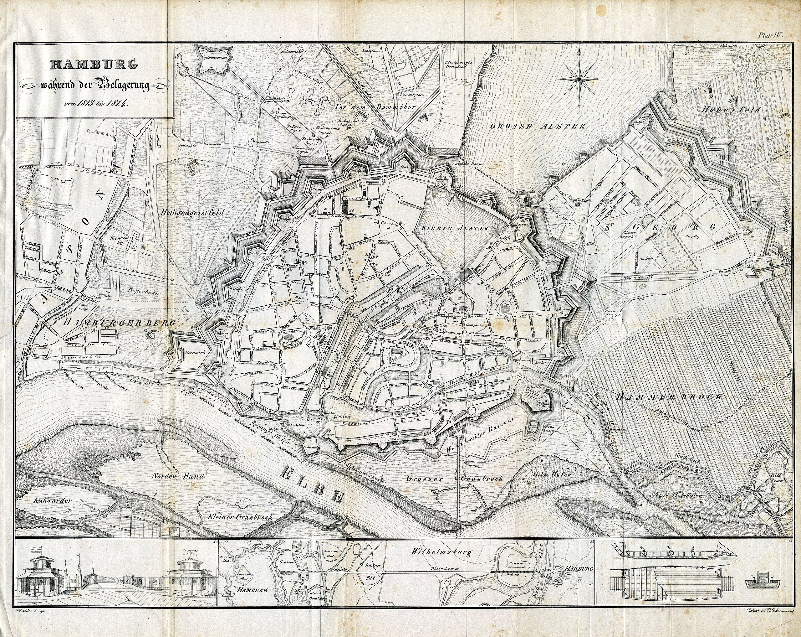
Karte von Hamburg während der französischen Besatzung 1813/1814
|
| Date | |
| Source | http://www.christian-terstegge.de/hamburg/karten_hamburg/ |
| Author | F. H. Neddermeyer: Topographie der Freien und Hanse Stadt Hamburg, Plan IV: "Hamburg während der Belagerung in den Jahren 1813 und 1814", Verlag Hoffmann & Campe, Hamburg 1832. |
Licensing
[edit]
|
This work is in the public domain in its country of origin and other countries and areas where the copyright term is the author's life plus 70 years or fewer. | |
| This file has been identified as being free of known restrictions under copyright law, including all related and neighboring rights. | |
File history
Click on a date/time to view the file as it appeared at that time.
| Date/Time | Thumbnail | Dimensions | User | Comment | |
|---|---|---|---|---|---|
| current | 15:52, 2 January 2011 | | 5,808 × 4,614 (7.63 MB) | Wmeinhart (talk | contribs) | {{Information |Description=Karte von Hamburg während der französischen Besatzung 1813/1814 |Source=http://www.christian-terstegge.de/hamburg/karten_hamburg/ |Date=1814 |Author=Neddermeyer |Permission= |other_versions= }} [[Category:Historical maps of H |
You cannot overwrite this file.
File usage on Commons
The following page uses this file:
File usage on other wikis
The following other wikis use this file:
- Usage on de.wikipedia.org
- Usage on en.wikipedia.org
- Usage on fr.wikipedia.org
- Louis Nicolas Davout
- Wikipédia:Sélection/France au XIXe siècle
- Wikipédia:Sélection/Premier Empire
- Portail:Hambourg
- Wikipédia:Sélection/Hambourg
- Siège de Hambourg
- Wikipédia:Sélection/Années 1810
- Wikipédia:Lumière sur/Mars 2014
- Wikipédia:Lumière sur/Siège de Hambourg
- Projet:Guerres napoléoniennes/Batailles
- Projet:Guerres napoléoniennes/Batailles/2
- Utilisateur:Damned/Brouillon
- Wikipédia:Sélection/France/Bons articles/E à L
- Usage on it.wikipedia.org
- Usage on ru.wikipedia.org
- Usage on sv.wikipedia.org
- Usage on tr.wikipedia.org
- Usage on zh.wikipedia.org
Metadata
Categories:
- Old maps of Hamburg
- Maps of Hamburg-Altona-Altstadt
- Maps of Hamburg-Altstadt
- Maps of Hamburg-HafenCity
- Maps of Hamburg-Hammerbrook
- Maps of Hamburg-Hohenfelde
- Maps of Hamburg-Neustadt
- Maps of Hamburg-Rotherbaum
- Maps of Hamburg-St. Georg
- Maps of Hamburg-St. Pauli
- Maps of Hamburg-Wilhelmsburg
- Maps of Hamburg-Kleiner Grasbrook
- French occupation of Hamburg 1806-1814
- Hoffmann und Campe
- 1832 works in Germany
- Hamburg in the 1810s
- Siege of Hamburg